Walk 2441 - printer friendly version
Lea Valley from Mill Green to Ware Walk
Author - Barry Mackie
Length - 9.5 miles / 15.4 km
Ascent - 330 feet / 100 metres
Grade - easy/mod
Start - OS grid reference TL240097
Lat 51.772247 + Long -0.20424282
Postcode AL9 5PA (approx. location only)
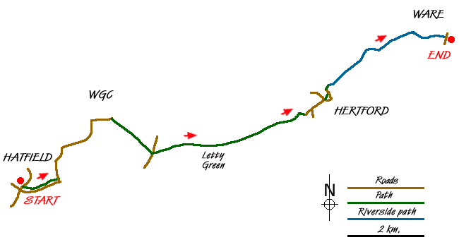
This Hertfordshire walk follows a section of "The Lea Valley Walk", a recognised 50m/80km trail that starts near Luton and continues to Bow, in East London. Through the length of the valley flows the River Lea (or Lee), which at various times during the walk, you'll get to see, cross or walk alongside. Although much of the route is through rural areas, parts of Welwyn Garden City (WGC), Hertford and Ware are crossed. There are regular bus services between WGC and Hertford, and Hertford and Ware, and also a direct rail link between Hertford and Ware.
The waymarker emblem for The Lea Valley Walk is a white swan on a dark green background, and the route is fairly well signposted. For most of this walk, the waymarkers are followed, and where it changes, this is detailed. Our walk starts outside the museum in Bush Hall Lane, Mill Green, near WGC, (Grid ref TL240097), and if you're using the same map as we did (the OS 1:25000), there may be some confusion here. Our map shows the path to run parallel on the other (south) side of the A414 dual carriageway, but the waymarker along the lane directs you along this (the north) side. We followed the waymarker as I think the other route no longer exists, and was probably altered because of the potential dangers of walking so close to this fast and busy road.
With the museum on your left, go east along Bush Hall Lane to the end and join the path that goes parallel, but a safe distance away from the A414. At the minor road, (Grid ref TL249100), turn left away from the dual carriageway and walk north along Gypsy Lane through the middle of the golf course, to the second mini roundabout. Turn right here into Ascots Lane to the next mini roundabout, with the hospital on your right. Turn right again into Howlands and continue to the next main roundabout. Here turn right into Cole Green Lane. At the top of the Lane, just before the junction with the B195 road, turn right into the signposted Cole Green Way (Grid ref TL264118).
This is a well made bridleway which was part of the old railway link between Welwyn and Hertford, and there now follows a pleasant walk through the countryside with only two roads of note; first under the A414, then a while later a minor road. Along the way you pass the old railway station of Cole Green and just off the track to its left is the Cowper Arms PH were you can stop for refreshments (Grid ref TL284111). Approaching the railway viaduct near Hertford, the Cole Green Way path forks to the right, follow this path, and go under the viaduct, to come out on the outskirts of Hertford with the football ground to your left. Here, look behind to your right, to see the useful information board about the Cole Green Way.
At the road turn left into Horns Road, which then becomes West Street, to reach the A414 dual carriageway (Gascoigne Way) (Grid ref. TL324123). The waymarker here directs you to the right, but a much better option is to cross the carriageway using the pedestrian crossing and walk through the grounds of Hertford Castle to the opposite side and come out at the road (Mill Bridge). Turn left and walk to the traffic lights. Turn right here and right again into Hartham Lane to reach the Leisure Centre on Hartham Common. Here there are toilet facilities and the chance to get some light refreshments. Go past the Leisure Centre (on your left) and take the path by the river to reach Hertford Basin, which will probably have a few canal boats moored up. Cross the two footbridges and the road bridge to the towpath on the other bank.
The remaining section of the walk uses this towpath to our finish at Ware, but is packed with things to see, of which the first is Hertford Lock. From here, continue along the towpath with Lea Island and the river on your left and Kings Mead Nature Reserve to your right to where the river (now called the Lee Navigation) is joined by the River Beane. Just downstream is a Victorian brick building called "New Gauge". This monitors the flow of water, approx 23 million gallons a day, drawn from the Lee into the start of the "New River" (an aqueduct that supplies drinking water to London). Further along the towpath, go under the A10 flyover and soon reach the (second) footbridge to take you over the river to Ware Lock. Come back over the footbridge and continue towards Ware, passing the 18th century gazebos (summerhouses) on the far bank. The white road bridge over the river (Grid ref. TL359141, Amwell End) is where the walk finishes. In the immediate vicinity are shops and pubs, and the rail station is just down the road.
Messaging & Social Media
Message Walking Britain and follow the latest news.

Mountain Weather
Stay safe on the mountains with detailed weather forecasts - for iOS devices or for Android devices.