Walk 2636 - printer friendly version
North Moor crossing from Okehampton to Bellever Walk
Author - Jake Robertson
Length - 14.5 miles / 23.6 km
Ascent - 2400 feet / 727 metres
Grade - mod/hard
Start - OS grid reference SX593945
Lat 50.733027 + Long -3.9951087
Postcode EX20 1EJ (approx. location only)
This is perhaps the easiest and shortest way to cross Dartmoor's North Moor, one of the finest and most alluring wildernesses in England. It is an enjoyable and rewarding walk, ideal for boosting confidence, and as it is all on paths and tracks the mist does not pose too much of a navigational problem.
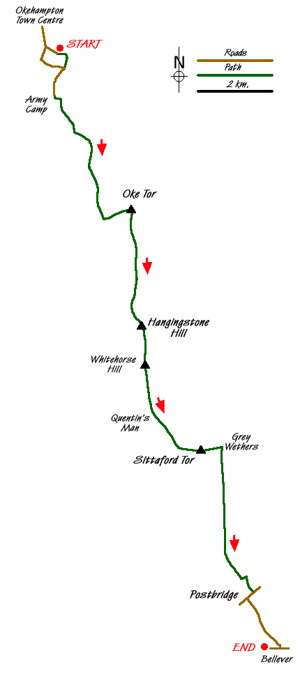
START - Okehampton Youth Hostel (Grid ref. SX 593945) which has a National Park car park. Leave the youth hostel and go left up the road, on the end of which a track and path brings you to a footbridge over the A30. Once over climb right diagonally through a field to the military road near Okehampton Camp. Walk along the road past the cattle grid near the camp. A little past this take a track on the left past Moorgate Cottage (Grid ref. SX 593932). This leads to a few confusing junctions of criss-crossing tracks but going straight on to a t-junction on a minor top (Grid ref. SX 598925), turning right down to another t-junction and turning left makes simple work of it.
From here keep to the main tarmac track over a ford then along a nice straight section, slipping into the upper East Okement valley to cross another ford. Just over turn left and cross the bottom of the valley then climb up on a path to Oke Tor (Grid ref. SX 613901). Turn right on a ridge path/track which leads for a swift and easy few miles to the remote 1979ft summit of Hangingstone Hill (Grid ref. SX 617862), with its military hut on top. About 3 miles from the nearest road, this is the heart of the Dartmoor wilderness, a barren and lonely spot with wide ranging views over the moor and northern and eastern Devon.
Go south onto the slightly lower top of Whitehorse Hill where there is a good view over southern Dartmoor, with Bellever forest visible down the valley of the East Dart. Descend down the ridge to the little cairn of Quentin's Man and thence into the Teign Valley. Ford two streams, which may be tricky after rain, and climb up by a wall to the 1766ft top of Sittaford Tor.
Drop down by a wall to the east to a lovely little hollow with the restored Grey Wethers stone circle, impressive and lonely with the conifers of Fernworthy Forest looming above. From the circle, a good path runs south into the East Dart valley high above the river, bringing one quite conveniently to Postbridge. Go right up the road, past the oft photographed bridge and the petrol station (they do a good pasty there and the owners are very friendly) to the National Park car park.
Go right down a signposted road for an easy mile to Bellever, the youth hostel being on the right. It is a delightful little cluster of building in the heart of a wild forest and a welcome sight after a long day in the wilderness, made all the better if you are staying in the hostel.
NOTE - for a longer and harder walk, ascend High Willhays from Okehampton then head southeast to Cranmere Pool then south over Cut Hill, Devils Tor and Beardown Tors to Two Bridges. This is a much more serious outing demanding excellent navigation and an appetite for boggy moors.
Messaging & Social Media
Message Walking Britain and follow the latest news.

Mountain Weather
Stay safe on the mountains with detailed weather forecasts - for iOS devices or for Android devices.