Walk 2662 - printer friendly version
Beacon Hill and Warnford Walk
Author - Lou Johnson
Length - 6.0 miles / 9.8 km
Ascent - 600 feet / 182 metres
Grade - easy/mod
Start - OS grid reference SU617212
Lat 50.986905 + Long -1.1223416
Postcode SO32 3NR (approx. location only)
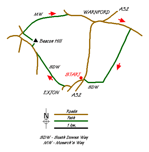
The village of Exton lies in the attractive Meon Valley just off the A32 main road. The start is a small parking area (grid ref. SU617212) which is reached by turning off the A32 and taking the northernmost of the two lanes off the main road into the village. Immediately after turning off the A32 the small parking area is evident on your left. Note that in fine weather and busy periods that this may get full quite quickly.
After parking, walk into the village with the River Meon on your left. The lane bears sharp right. If you want to have some food or refreshments there is a pub down the lane to your left, but for the walk you need to continue along the lane passing the parish church which will be on your right. The road gradually bends left. After approximately 200 metres look out for a South Downs Way sign on the right (grid ref. SU611210). Follow this sign and enter open farmland. Ahead lies the first objective, namely Beacon Hill.
The onward route is clear. You cross an access track and begin to climb more steeply with an improving view behind you. Reaching a lane, turn right. It is worth looking left as you have an excellent panorama that includes the Solent and the Isle of Wight beyond. After a short way along the lane a signed path on the right (grid ref. SU601223) should be followed to the trig point on Beacon Hill. The view is particularly fine over the Meon Valley.
From the trig point take the clear track that heads north-west to a car park and road junction (gird ref. SU598227). Turn right here and walk through pleasant woodland. You are now on the Monarch's Way. Follow the well signed path as you descend gradually towards Warnford. In places the landowner has perhaps provided rather too much signage but this is better than none! Reaching a road, turn right into Warnford. As you reach the main road note the watercress ponds on your left.
At the A32 turn left, walk past the pub to reach a road junction (grid ref. SU624231). Turn right up this lane climbing a little in the process. After just over half a mile you reach a bridge over the old railway (grid ref. SU633228). Take the path on the left hand side of the road and descend to the old trackbed. Turn back on yourself and walk under the road. You now have a straightforward walk on a well graded path. This railway was called the Watercress Line and a section to the north of here is now preserved with steam trains in operation.
Crossing the lane to Peake farm (grid ref. SU628218) is about the half way point to where we will leave the old railway. This is good walking and you can keep a good pace along this section. At grid ref. SU624211 you leave the old railway and follow the signed South Downs Way back to the start. This last section does not encourage you to step out as there are some tree roots and other minor obstructions to negotiate. Reaching the main road, take care and cross to the parking area opposite.
Messaging & Social Media
Message Walking Britain and follow the latest news.

Mountain Weather
Stay safe on the mountains with detailed weather forecasts - for iOS devices or for Android devices.