Walk 2813 - printer friendly version
Long Itchington to Ufton and Return Walk
Author - Raymond Whittall
Length - 8.0 miles / 13 km
Ascent - 250 feet / 76 metres
Grade - easy/mod
Start - OS grid reference SP414652
Lat 52.283389 + Long -1.3945422
Postcode CV47 9QH (approx. location only)
The thing about walking to me is that I don't plan it. I just stroll out of the door with no particular destination in mind. Here in Long Itchington, South Warwickshire, we are spoilt for choice. Competing to entice the aspiring walker are a network of public footpaths, the Grand Union Canal and the long disused LNWR (London and North Western Railway) cutting that ran from Weedon to Leamington Spa. The other day, I used a combination of the above, to surprising effect. (One of the benefits, for me, of not planning, is where one can end up!)
The thing about walking to me is that I don't plan it. I just stroll out of the door with no particular destination in mind. Here in Long Itchington, South Warwickshire, we are spoilt for choice. Competing to entice the aspiring walker are a network of public footpaths, the Grand Union Canal and the long disused LNWR (London and North Western Railway) cutting that ran from Weedon to Leamington Spa. The other day, I used a combination of the above, to surprising effect. (One of the benefits, for me, of not planning, is where one can end up!)
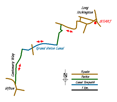
I continued on, down the lane for about another half a mile, then struck off left, onto the deeply rutted, but dry, bridle path. I know that this path climbs quite steeply for about two hundred yards, then levels out, by a hay-barn, and descends to within a dozen yards of the Grand Union canal at Bascote Lock. As I climbed, I noticed the crop-planted fields, flanking the path on either side, were now sprouting green shoots. Then I stopped. A Yellowhammer had alighted on top of the low hedge to my right. A sighting of this lovely bird is a lot rarer these days and I am always delighted to see one.
Once on the canal towpath, I turned right, towards Leamington Spa. Nowadays, there is no incumbent occupying the Bascote lock-keeper's cottage and it has become a very attractive family home. There are four locks, close together on this stretch (numbers 14 - 17 of 160 in total on the Grand Union). There was a fair bit of activity. Three narrow boats were negotiating the system as I walked by. I noticed it was mainly ladies who set about winding handles and heaving on gates while the men steered the impossibly long craft. Not being a boating person, I'm not sure what to make of that.
Apart from the boats, there were several pairs of mallards gliding serenely on the water. Breeding would have been on their mind at this time of year, so they may not have felt as serene as they appeared. More unusually, I noticed two pairs of Canada Geese reconnoitring the opposite bank, probably in search of a suitable nesting site. After a further mile or so, I passed another fine lock keepers cottage at Welsh Road Lock (number 18 - only 142 to go!).Then I came to a bridge (number 31), with a set of newly installed, wooden steps at the side. They looked inviting, so I climbed them. Over the bridge ran a track which a Warwickshire County Council sign ambitiously described as a 'county unclassified road'. It even had a name - 'Centenary Way'.
Subsequent investigation on the internet reveals that Centenary Way consists of a series of connected paths and roads that run all the way from the Tame Valley on the Staffordshire border, through George Eliot country, around Nuneaton, to Coventry, Kenilworth and Leamington Spa. It finishes up, having passed through the Burton Dassett Hills, on Ilmington Downs, south of Stratford upon Avon. A total distance of about 98 miles.
The section I walked was in poor condition - deeply rutted and probably virtually impassable in the wet. Today it was very pleasant, winding through farmland. I came across an old, decrepit, but very attractive barn with an interesting, diamond shaped, brick pattern on the end wall. Further inspection revealed that the design was repeated, twice on each of the side walls and again on the other end wall. Each of the diamonds consisted of thirty six bricks laid with their ends facing outwards, creating ventilation holes. I understand these features are known as 'Biertons'. No doubt there's a barn expert out there, who will know whether or not this is correct .Then, a church appeared, on top of the hill ahead of me - a clear sign of habitation. I continued on, curious to find out where I was. My path climbed the hill towards the church, and I could hear the hum of traffic getting closer. A building came into view on my right. There was a car park outside and some activity. I approached and a sign read 'The Wedding Barn'. I had definitely reached civilisation!
I was about to find out where I was. I could now see the traffic passing by just ahead and reached the road, just below a sign proclaiming my mystery destination - 'Ufton'. To my left, on the brow of the hill, lay the church and The White Hart pub. I knew where I was and, if I'd had any cash on me, I would have celebrated with a pint!
Messaging & Social Media
Message Walking Britain and follow the latest news.

Mountain Weather
Stay safe on the mountains with detailed weather forecasts - for iOS devices or for Android devices.