Walk 2841 - printer friendly version
Seat Sandal via Grisedale Tarn from Grasmere Walk
Author - Lou Johnson
Length - 5.0 miles / 8.1 km
Ascent - 2100 feet / 636 metres
Grade - moderate
Start - OS grid reference NY336091
Lat 54.472899 + Long -3.0261194
Postcode LA22 9RU (approx. location only)
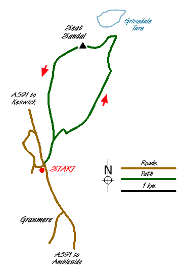
Seat Sandal is a neglected Lakeland fell as far as walkers are concerned. A solitary summit, it occupies a wonderful position providing views to many of Lakeland's great hills and mountains and forms the basis of this lake District circular walk. The route is straightforward apart from a short but steep ascent during the final approach to the summit of Seat Sandal. Paths are generally easy to follow although the descent off the summit needs care in poor visibility.
The start is one mile north along A591 from Grasmere at Mill Bridge (Grid ref. NY336091). Parking is available in two lay-bys and a few other places although there are restrictions at certain times of the year. At busy times of the year an early start is essential. As an alternative there is the frequent bus service between Windermere, Ambleside and Keswick passing the start. After parking locate the bridleway (signed Patterdale) on the east side of the main road almost opposite the lane leading down towards Low Mill Bridge.
The bridleway climbs gently with Tongue Gill below on your right. Ahead the slopes of Seat Sandal rise quite steeply. Cross the footbridge (Grid ref. NY339098) and bear right to cross the second footbridge. Go slightly left past a concrete reservoir to reach the path on the south side of Tongue Gill. At first the path heads upstream at a gentle angle and progress towards Grisedale Hause is quite fast. Passing a waterfall the path crosses to the other side of the Gill and the ascent gets steeper. Keeping ahead past a large depression on your right, the path climbs to Grisedale Hause from where you get your first sight of Grisedale Tarn.
This is a superb place to rest as you are surrounded by high fells with Fairfield, St Sunday Crag and Dollywagon Pike the most dominant. At the hause turn left and follow the wall to the foot of the climb onto Seat Sandal. There is a rather unpleasant, loose path that climbs steeply to the right of the wall. The loose section is short-lived and soon the conditions underfoot improve as you gain height. There are paths either side of the wall with the left-hand one providing the preferred route. The path becomes less steep as the summit area is reached with a cairn marking the highest spot. From here the best views are towards the Helvellyn range, Fairfield and St Sunday Crag.
The onward path is less distinct and care is needed in places to ensure you are heading in the right direction. The first key to the descent is a further cairn located roughly due west of the summit. From here the views north to Skiddaw and Blencathra and west to the Scafells and Great Gable are at their best. From this second cairn the path heads roughly southwest over grass. It is a superb way down with virtually no erosion and grass underfoot all the way down to the valley. Reaching a wooden gate in a wall, continue straight ahead and keeping the same line continue through a second wooden gate. Shortly afterwards, the path leads you down to a cast iron gate, which provides access to the bridleway used at the start of the walk. Turn right and you will be back at the main road in a few minutes.
Messaging & Social Media
Message Walking Britain and follow the latest news.

Mountain Weather
Stay safe on the mountains with detailed weather forecasts - for iOS devices or for Android devices.