Walk 3540 - printer friendly version
The Derwent Edge from Cutthroat Bridge Walk
Author - Mike Bexley
Length - 10.0 miles / 16.3 km
Ascent - 1970 feet / 597 metres
Grade - moderate
Start - OS grid reference SK217874
Lat 53.383006 + Long -1.6752311
Postcode S6 6GL (approx. location only)
For interest, views and variety I think this is the best area in the Peak District National Park. Starting with an easy path to a stunning view its then a pleasant stroll along Derwent Edge prior to descending down to Ladybower Reservoir. You will then have a very steep path up to the top again before descending back to the start with plenty to talk about! Don't forget your camera.
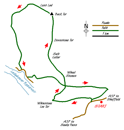
The Peak District walk starts at the large lay-by on the A57 Sheffield to Snake Pass road just above Cutthroat Bridge (Grid ref SK217874). After parking walk down the narrow path alongside the busy road to Cutthroat Bridge. Cross the road with care and go through the gate opposite. A body was found with its neck cut under this bridge, so with that sobering thought proceed up the path with the brook at first on your right. The path is a very gradual climb. At nesting time the grouse will attack you on this path. I have never known it elsewhere and it must be in their genes. On reaching the top bear to the left to the fantastic 360 degree view point - Whinstone Lee Tor (Grid ref SK198874).
To continue, walk ahead and up the path winding through the rocks. The path, and there is only one, proceeds north along wide Derwent Edge passing many unique rock formations. The first and the most impressive is the Wheel Stones (Grid ref SK202885) which in certain light looks like a coach & horses. The final and largest rock mass is Back Tor (Grid ref SK198910) with its white trig point. This is the end of the edge walk and remember not to forget to climb to the top for further views.
Now take the left fork from Back Tor down to Lost Lad (Grid ref SK193912) with its cairn and topograph erected in memory of W.H.Baxby of the Sheffield Clarion Ramblers. The story goes that a young shepherd died here with his Sheepdog 'Tip' still alive alongside him. The words 'Lost Lad ' were found scratched on the nearby rocks. This was before the dam was built in the valley so from the valley below it was a lot higher from safety - this is a depressing walk really! Keep on the path descending steeply to Green Stitches, look out for the path on your left, near some pallet type shooting positions.
Proceed left on this path turning left at each Y junction as the path swings round towards the copse of fir trees down on your left. Proceed through the first broken wall to the next wall (Grid ref SK182902). The fir trees should now be near you on your left. Turn right and with the wall close to your left, walk down the bridle way cum path to Briery Side, passing Wellhead Farm on the way. You climb over several lift-up walker friendly stiles before reaching the private road alongside Ladybower Reservoir (Grid ref SK184887).
Turn left, with the reservoir on your right, passing the old gates of a house long since gone and soon after an explanation board detailing the lost village. Keep to the road and just before the five bar gate across the road take the paved path on your left (Grid ref SK187884), which climbs steeply up to the buildings at Grindle Clough. There is a shelter here with a welcome bench seat. The path continues to climb steeply but gets easer the higher you go. On reaching the gate in the wall (Grid ref SK198884) turn right then left.
The climb is a lot easer now and the top is soon reached. Cross over the edge path and take the path opposite walking down through the heather moor, passing grouse butts. Cross over the Highshaw Clough stream and through a five bar gate. On reaching the bottom, prior to where the path turns sharp left, either go over the stone wall stile or through the gate (Grid ref SK220879). Turn right, with the wall now on your right, and continue on the path to climb over a high wall stile. The path continues over to the brook then via stepping stones to the path where you turn left down to Cutthroat Bridge and with care back to the start.
Messaging & Social Media
Message Walking Britain and follow the latest news.

Mountain Weather
Stay safe on the mountains with detailed weather forecasts - for iOS devices or for Android devices.