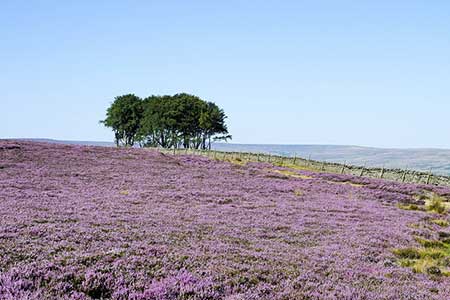
Sunnyside Edge from Wolsingham
Durham Walk
County/Area - Durham
Author - Lou Johnson
Length - 7.5 miles / 12.2 km Ascent - 800 feet / 242 metres
Time - 4 hours 30 minutes Grade - easy/mod
Maps 

| Ordnance Survey Explorer OL31 | Sheet Map | 1:25k | BUY |
| Anquet OS Explorer OL31 | Digital Map | 1:25k | BUY |
Walk Route Description
Click image to see photo description.
This circular walk from Wolsingham in Weardale (County Durham) explores a section of the River Wear before turning south to make a steady ascent onto the moors near the Elephant Trees. The route then turns east along Sunnyside Edge from where you can enjoy views across Weardale. The walk includes a section of the Weardale Way.
The start is the car park adjacent to Wolsingham railway station (grid ref. NZ076369). After parking walk past the station on your left to the road. Turn left, cross the road, and take the first path on the right with adjacent fingerpost. Continue along path with the railway on your left and the river on your right. After just over a kilometre, you reach a caravan site on the far side of the railway on your left. Continue ahead to join a road to Kingfisher Leisure Park. Just before the park, turn right ad follow the riverside path around the site. After the last caravan, leave riverside path and turn left to cross the railway track. Ascend some steps, pass through two gates to reach a lane.
Turn right and follow the lane around to the left. Keep straight ahead at the first junction and take the left fork shortly afterwards to join the Weardale Way (grid ref. NZ039364). Reaching West Biggins Farm, continue through the yard with a large barn on your left. Then keep ahead to pick up a track in front of some trees. After a gate, the track bends sharp right and passes under power cables. Fork left and follow the track as it curves left to run alongside a wall (which will be on your right). Follow the wall up the field to another gate (grid ref. NZ037353).
Entering the next field, the grassy track continues uphill to a further gate before bearing south roughly following a wall on your left to a gate and the main track along Sunnyside Edge (grid ref. NZ042344). The onward route follows the track left. However, a short distance along the track to the right are the Elephant Trees, so named as they appear to be a herd of elephants when viewed from across the dale. Follow the clear track along the edge enjoying an excellent view over Weardale and the moors beyond.
After 1.5 kilometres of easy walking, you reach a stand of trees on the left and the access drive (grid ref. NZ063349) to Harthope Farm on the right. Turn left following the Weardale Way. The descending path initially runs beside the trees but soon continues across fields with the wall on your left. Entering the third field the path follows the wall now on your right. Continue beside the wall to the first gate on your right and turn right. Follow the track to reach Towdy-Potts Farm (grid ref. NZ067361). Pass between the buildings and follow the farm's access drive past Ashes House Farm and out to a road (grid ref. NZ074367). Turn left and follow the road back to Wolsingham station and the car park.
Other walks nearby
| Walk 1948 | Tunstall Reservoir | easy/mod | 7.3 miles |
| Walk 2382 | Smiddy Shaw Reservoir Circular | easy/mod | 6.2 miles |
| Walk 3634 | Catterick Moss & Bollihope Carrs | moderate | 5.6 miles |
| Walk 2089 | College Edge & Cuthbert's Currick from Edmundbyers | easy/mod | 8.0 miles |
| Walk 2393 | Weardale Circular from Westgate | easy/mod | 6.4 miles |
| Walk 2157 | Romaldkirk & Cotherstone | easy | 5.0 miles |
| Walk 2170 | Eggleston & Mickleton from Romaldkirk | easy/mod | 5.8 miles |
| Walk 1005 | Harter Fell & Grassholme | moderate | 8.0 miles |
| Walk 1482 | Crossthwaite Common from Middleton-in-Teesdale | moderate | 9.8 miles |
| Walk 1483 | Eggleston & Romaldkirk from Middleton-in-Teesdale | easy/mod | 9.8 miles |
Recommended Books & eBooks
Walking in County Durham
 Guidebook offering detailed descriptions of 40 day walks, plus 10 traffic-free cycle routes along old railway trackbeds. Together they cover 450 miles and spread all over County Durham to show the region's history and natural wonders. The terrain covered ranges from field paths to open moorlands, from the North Sea to the high Pennines.
More information
Messaging & Social Media
Message Walking Britain and follow the latest news.

Mountain Weather
Stay safe on the mountains with detailed weather forecasts - for iOS devices or for Android devices.