Allendale Town Circular
Northumberland County Walk
County/Area - Northumberland County
Author - Lou Johnson
Length - 6.6 miles / 10.7 km Ascent - 700 feet / 212 metres
Time - 4 hours 0 minutes Grade - easy/mod
Maps 

| Ordnance Survey Explorer OL43 | Sheet Map | 1:25k | BUY |
| Anquet OS Explorer OL43 | Digital Map | 1:25k | BUY |
Walk Route Description
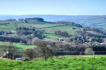
Click image to see photo description.
This circular walk from Allendale Town explores the East Allen Valley and surrounding countryside. The route initially crosses the higher land to the north of the dale passing through the village of Catton along the way. The walk continues west before dropping into the valley to follow the river upstream along a section of Isaac's Tea Trail back to the start.
The start is the centre of Allendale Town where on-street parking is available (grid ref. NY837558). After parking follow the B6303 north (signed to Hexham). Continue for 800 metres following the road around a left-hand bend across the Philip Burn. Take the next road on the right (just before a bus top on the left). Head uphill and after 170 metres take the first footpath on the left through a wooden gate (grid ref. NY842564). Continue up the enclosed path to a field and follow the waymarked path on the left. Initially head half right to a wall corner and the follow the wall keeping it on your right. Continue past a small stand of trees and continue ahead into a field following the left-hand edge. Towards the end of the field turn left and pass to the left of Houstry Farm (grid ref. NY836572). Follow the waymarks and join the farm's access drive to a lane (grid ref. NY834575).
Turn right and after 250 metres turn left at the fingerpost. The path passes to the left of Stone Stile Farm. Continue across fields and cross Catton Burn. 150 metres beyond the burn turn left at a footpath junction. Follow the path across two narrow fields and join an enclosed track to the road in Catton. Turn right along the B6295 and almost immediately left onto a track between houses. Continue west along the enclosed track. After 700 metres you continue across fields below Pasture House maintaining direction to reach a lane (grid ref. NY818578). Continue west following the fingerpost and continue across fields passing below Old Town to reach Colliery Lane.
Turn left and descend into the valley passing the remains of the old railway. Follow the lane down to cross the river and take the first footpath on the left (grid ref. NY808577). After 800 metres you enter woodland and soon after join Isaac's Tea Trail. Continue along this trail to reach the B6295 (grid ref. NY831566). Turn left across the river and take the first path on the right. Follow the riverside path back to Allendale Town.
Other walks nearby
| Walk 1942 | Watson's Pike & Hexhamshire Common | easy/mod | 6.0 miles |
| Walk 1677 | Peel Crags & Winshield Crags from Vindolanda | easy/mod | 7.8 miles |
| Walk 2671 | Hotbank Crags & Housesteads from Vindolanda | easy | 5.3 miles |
| Walk 3331 | Cragend & Crow Crags from Housesteads | easy/mod | 8.4 miles |
| Walk 2815 | Pennypie and Blanchland from Baybridge | easy/mod | 3.8 miles |
| Walk 3315 | Warlaw Pike & Birkside Fell from Blanchland | moderate | 8.0 miles |
| Walk 3722 | Buckshott Fell & Sikehead Mines | easy/mod | 6.5 miles |
| Walk 3404 | Hadrian's Wall - Cawfields to Steel Rigg | easy/mod | 3.5 miles |
| Walk 1198 | Hadrian's Wall & Steel Rigg | moderate | 8.0 miles |
| Walk 2337 | Greenlee Lough and Steel Rigg | easy/mod | 7.5 miles |
Recommended Books & eBooks
Walking in Northumberland
 This guidebook contains detailed route descriptions for 36 day walks in Northumberland including the Cheviot Hills. The terrain varies from wild walks and craggy ascents to gentle riverside strolls. Each route ranges from 4 to 16 miles in length and there is the opportunity to link several walks together to create longer treks.
More information
Hadrian's Wall Path
 Hadrians Wall Path guidebook to walk the 84 mile National Trail. Described in both directions, the main description is west to east between Bowness-on-Solway and Wallsend, Newcastle, with extensions to Maryport and South Shields. With extensive historical information related to this World Heritage site and separate 1:25,000 OS map booklet included.
More information
Messaging & Social Media
Message Walking Britain and follow the latest news.

Mountain Weather
Stay safe on the mountains with detailed weather forecasts - for iOS devices or for Android devices.