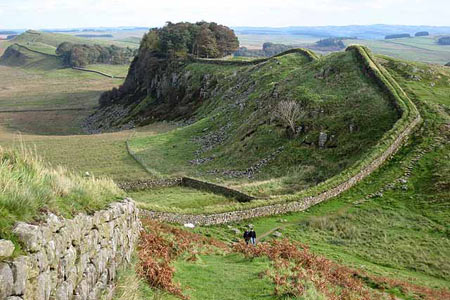
Cragend & Crow Crags from Housesteads
Northumberland Walk
Nat Park - Northumberland
County/Area - Northumberland County
Author - Lou Johnson
Length - 8.4 miles / 13.7 km Ascent - 900 feet / 273 metres
Time - 5 hours 10 minutes Grade - easy/mod
Maps 

| Ordnance Survey Explorer OL43 | Sheet Map | 1:25k | BUY |
| Anquet OS Explorer OL43 | Digital Map | 1:25k | BUY |
| Ordnance Survey Landranger 87 | Sheet Map | 1:50k | BUY |
| Anquet OS Landranger 87 | Digital Map | 1:50k | BUY |
Walk Route Description
Click image to see photo description.
The walk starts from Vercovicium, now known as Housesteads Roman Fort, which was an auxiliary fort on Hadrian's Wall and follows one of the best preserved sections of the wall before looping north to Cragend and across open country to Crow Crags before returning to follow Hadrian's Wall from Sewing Shields back to the start.
There is a car park beside the B6138 (grid ref. NY793683) or you can reach the start using the Hadrian's Wall bus service AD122 which runs from April through to September. From the car park walk north towards Hadrian's Wall and follow the wall west. The path continues along the top of Housesteads and Cruddy's Crags to reach the Pennine Way (grid ref. NY7816860. Turn right (north) onto the Pennine way and follow the well marked trail north to Cragend. The onward path is clearly marked and takes you into Wark Forest at a ladder stile.
After just over 200 metres (grid ref. NY780709) bear right onto the path leading to a cottage at Haughtongreen (grid ref. NY787712). Continue on the path signed to "Lonborough" to exit the forest at grid ref. NY790716). From this point the next objective is Crow Crags and you need to leave the path to Lonborough and follow a less distinct path heading ENE (not marked on OS maps) that leads across Crow Crags to a sheepfold (grid ref. NY798720). The path (indistinct at times) leads to a footbridge, Cross this and continue across what can be quite boggy ground to Stell Green (grid ref. NY807722).
From Stell Green take the track heading south and follow this back to Hadrian's Wall at Sewing Shields. Turn right along the wall and follow the clear path over this well preserved and scenic section back to Housesteads.
Other walks nearby
| Walk 1677 | Peel Crags & Winshield Crags from Vindolanda | easy/mod | 7.8 miles |
| Walk 2671 | Hotbank Crags & Housesteads from Vindolanda | easy | 5.3 miles |
| Walk 1198 | Hadrian's Wall & Steel Rigg | moderate | 8.0 miles |
| Walk 2337 | Greenlee Lough and Steel Rigg | easy/mod | 7.5 miles |
| Walk 3404 | Hadrian's Wall - Cawfields to Steel Rigg | easy/mod | 3.5 miles |
| Walk 2803 | Hadrian's Wall and Haughton Common | hard | 20.0 miles |
| Walk 1786 | Hadrian's Wall & Simonburn circular | easy/mod | 6.8 miles |
| Walk 3343 | Hadrian's Wall, Walltown Crags & Aesica | easy/mod | 5.0 miles |
| Walk 1987 | Allendale Town Circular | easy/mod | 6.6 miles |
| Walk 1477 | Bellingham to Kiln Rigg by Pennine Way Circular | moderate | 14.3 miles |
Recommended Books & eBooks
The Pennine Way
 Guidebook to the Pennine Way National Trail with OS map booklet. The 265 mile route from Edale to Kirk Yetholm takes three weeks to walk and is suitable for fit and experienced long distance walkers. The route crosses the Peak District, Yorkshire Dales and North Pennines National Parks. Includes separate OS 1:25,000 map booklet of the route.
More information
Walking in Northumberland
 This guidebook contains detailed route descriptions for 36 day walks in Northumberland including the Cheviot Hills. The terrain varies from wild walks and craggy ascents to gentle riverside strolls. Each route ranges from 4 to 16 miles in length and there is the opportunity to link several walks together to create longer treks.
More information
Messaging & Social Media
Message Walking Britain and follow the latest news.

Mountain Weather
Stay safe on the mountains with detailed weather forecasts - for iOS devices or for Android devices.