Horsey Gap from Horsey
The Broads Walk
Nat Park - The Broads
County/Area - Norfolk
Author - Lou Johnson
Length - 3.7 miles / 6 km Ascent - 90 feet / 27 metres
Time - 2 hours 0 minutes Grade - easy
Maps 

| Ordnance Survey Explorer OL40 | Sheet Map | 1:25k | BUY |
| Anquet OS Explorer OL40 | Digital Map | 1:25k | BUY |
Walk Route Description
Click image to see photo description.
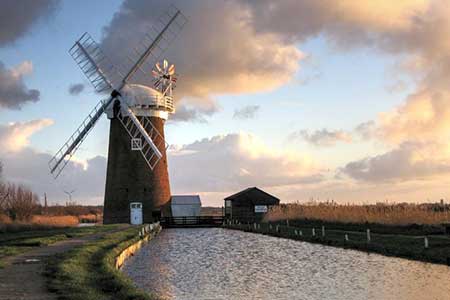
A short Norfolk circular walk from Horsey. The route starts from the restored Horsey Drainage Mill close to Horsey Mere. The walk crosses farmland to reach dunes and a glorious sandy beach. The route then follows a short section of Norfolk Coast Path to Horsey Gap, from where a return across fields takes you through the village and onto the shores of Horsey Mere.
The start is the National Trust pay and display car park adjacent to Horsey Drainage Mill (grid ref. TG457223). After parking return to the entrance and cross the road to a stile opposite. Follow the path beside a small plantation and then follow the waymarks as the path turns left. Continue along a clear track to reach a tarmac lane (grid ref. TG463223). Turn right and continue along the track to reach the dunes and the Norfolk Coast Path. Turn left and either walk along the coast path or along the beach.
After just over a kilometre, you reach Horsey Gap, with its large car park. At this point turn inland and follow the car park access road to reach a junction with a road. Turn right and after 100 metres turn left onto a grassy path running along the left-hand edge of a field. The field path soon joins a tarmac lane. Continue ahead past the church on your right. Follow the lane as it bends left and then at the next junction, bear right to join the main road through the village (grid ref. TG459229). Turn road and follow the footpath on the left-hand side of the road. After 400 metres turn right onto a gravel track and follow this to the shores of Horsey Mere. Continue along the side of the Mere back to the drainage mill and car park.
Other walks nearby
| Walk 3608 | Martham Ferry & River Thurne from West Somerton | easy | 4.0 miles |
| Walk 3609 | Winterton Ness from West Somerton | easy | 5.4 miles |
| Walk 3694 | River Thurne & Hickling Broad from Potter Heigham | easy/mod | 6.4 miles |
| Walk 2129 | River Ant & How Hill from Ludham | easy | 6.7 miles |
| Walk 2839 | St Benet's Abbey & How Hill from Ludham | easy/mod | 8.8 miles |
| Walk 2128 | Stokesby & Muck Fleet from Fleggburgh | easy | 7.1 miles |
| Walk 2320 | Muck Fleet & River Bure from near Oby | easy/mod | 8.7 miles |
| Walk 2239 | River Bure and Tunstall Dike from Acle | easy | 6.1 miles |
| Walk 2240 | The River Bure & Upton from Acle | easy | 5.0 miles |
| Walk 2297 | Honing & East Ruston Circular | easy/mod | 6.4 miles |
Recommended Books & eBooks
No suggestions for this area.Messaging & Social Media
Message Walking Britain and follow the latest news.

Mountain Weather
Stay safe on the mountains with detailed weather forecasts - for iOS devices or for Android devices.