Honing & East Ruston Circular
The Broads Walk
Nat Park - The Broads
County/Area - Norfolk
Author - Lou Johnson
Length - 6.4 miles / 10.4 km Ascent - 150 feet / 45 metres
Time - 3 hours 20 minutes Grade - easy/mod
Maps 

| Ordnance Survey Explorer 252 | Sheet Map | 1:25k | BUY |
| Anquet OS Explorer 252 | Digital Map | 1:25k | BUY |
Walk Route Description
Click image to see photo description.
Starting from the former Honing railway station this Norfolk walk uses a section of the Weavers' Way, visits an isolated church, crosses farmland to East Ruston and then continues along the disused North Wailsham & Dilham Canal. A portion of the walk lies within the boundary of the Broads National Park.
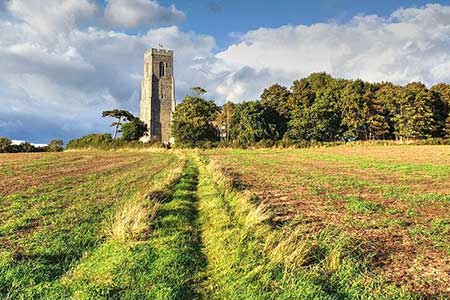
The start is the free Weavers' Way car park adjacent to Honing railway station (grid ref. TG317276). After parking walk to the platform and turn right along the Weavers Way soon passing through gates on Station Road. After 600 metres turn left off the old railway onto Canal Farm Lane (track). Follow the track back to Station Road and turn right. Turn right at the next T-junction and continue to where the road forks. Keep left here, signed to Stalham. Just after a house on the left, turn left through a gap in a hedge (with adjacent waymark post). Follow the path to reach St Peter & St Paul Church (grid ref. TG326280).
Turn right into churchyard and pass to the right of the church to exit at a gate to a road. Cross the road to the footpath opposite which runs with hedge right to a cross track. Turn right and then left onto the continuing path with a hedge to your left. This path soon reaches East Ruston Road. Turn right and continue to the next junction. Turn left signed to Honing Common and then fork left at the next junction. After 70 metres, turn left onto a path with adjacent fingerpost. The path crosses a small bridge at the end of the first field and then maintains direction across two more fields to re-join East Ruston Road (grid ref. TG338279).
Turn right and at the next junction turn right into Honing Road. Continue along the road to a crossroads and turn right into Chapel Road (signed to Stalham). At the end of the houses on the left, the road bends left and shortly after turn right in front of a house to join the Weavers' Way. Turn left and after 300 metres turn right along a path. Cross small bridge to a stile. Cross the stile and turn left and continue with a hedge on your left to a gate. Once through the gate walk half-right along a grassy track to the canal. Bear left along the canal to Tonnage Bridge. Cross the bridge and turn right to join a clear path beside the remains of the disused canal.
Follow the towpath for just under three kilometres passing through sections of woodland along the way. Reaching Dillam Lock, turn right across a footbridge at the end of the old lock and follow the path through trees to regain the Weavers' Way. Turn left and return to the car park which is reached after an easy walk of a kilometre and a half.
Other walks nearby
| Walk 3678 | Brampton & the Bure Valley from Buxton | easy/mod | 6.0 miles |
| Walk 2129 | River Ant & How Hill from Ludham | easy | 6.7 miles |
| Walk 2839 | St Benet's Abbey & How Hill from Ludham | easy/mod | 8.8 miles |
| Walk 3694 | River Thurne & Hickling Broad from Potter Heigham | easy/mod | 6.4 miles |
| Walk 1855 | Horsey Circular | easy | 5.1 miles |
| Walk 1992 | Horsey Gap from Horsey | easy | 3.7 miles |
| Walk 3608 | Martham Ferry & River Thurne from West Somerton | easy | 4.0 miles |
| Walk 3609 | Winterton Ness from West Somerton | easy | 5.4 miles |
| Walk 2151 | Metton & Felbrigg Hall | easy/mod | 6.2 miles |
| Walk 2128 | Stokesby & Muck Fleet from Fleggburgh | easy | 7.1 miles |
Recommended Books & eBooks
No suggestions for this area.Messaging & Social Media
Message Walking Britain and follow the latest news.

Mountain Weather
Stay safe on the mountains with detailed weather forecasts - for iOS devices or for Android devices.