Walk 2095 - printer friendly version
Simonside Hills & Rothbury Walk
Author - Lou Johnson
Length - 7.9 miles / 12.8 km
Ascent - 1400 feet / 424 metres
Grade - moderate
Start - OS grid reference NU057015
Lat 55.3075600 + Long -1.9117550
Postcode NE65 7SH (approx. location only)
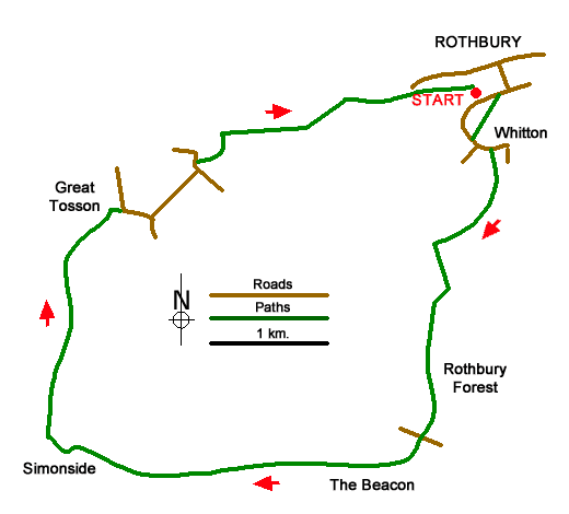
This walk from Rothbury in Northumberland explores the south side of the Coquet Valley. The route climbs steadily onto the ridge of the Simonside Hills and continues west to reach Simonside (430 m). Descending into the Coquet Valley the route continues along the river back to the start. Points on interest include Whitton Pele Tower, the Iron Age hillfort of Lordenshaws, splendid views to the Cheviots and another pele tower in Great Tosson.
The start is Cow Haugh pay and display car park on the south side the River Coquet (grid ref. NU057015. After parking exit the car park and turn left towards the road bridge over the river. Do not cross the bridge but turn sharp right up a lane as indicated by the fingerpost. Where the lane turns sharp left continue ahead on the signed footpath. Climb steadily across fields to a road (grid ref. NU056011). Turn left into Whitton. After 200 metres turn right onto the signed bridleway (Hillhead Road) and continue for just over a kilometre, passing Sharp's Folly, to a junction (grid ref. NU053003).
Turn left and follow the access drive south to Whittondean Farm. Follow the track right after passing the farm soon leaving the track on a path off to the right. The path heads south soon passing Lordenshaws hillfort on your left. Continue ahead up the clear path to a small car park (grid ref. NZ053988). Pass through the car park and cross the road to the paved path opposite. The onward path is easy to follow and is paved in places to protect against further erosion. The path climbs to The Beacon followed by a short descent and an ascent onto Dove Crag. A short descent leads to the final climb to Simonside (grid ref. NZ024987). This section of the walk offers a magnificent view north to The Cheviots.
A steep descent from Simonside leads down to a track with adjacent information board (grid ref. NZ022988). Turn right along the track and after 150 metres bear left onto a path through heather by a marker post. Continue downhill along the path which soon turns right. Continue along the path, go straight across a track, and follow the path into forest. The path continues north and exits the trees (grid ref. NZ024999). The onward path enters a field and runs parallel to the edge of the forest on your right. Follow the path to the end of the forest (by a big tree) and bear half right to a track keeping the farm on your right.
Turn right along the track into Great Tosson. Reaching the road, continue ahead passing the remains of Tosson Tower on your right. Just past a parking area, fork left and follow the lane to a T-junction. Turn left and at the next junction head right along a no-through road. Follow the lane which soon becomes a track and follow it around a right-hand bend. Cross the River Coquet and almost immediately take the footpath on the right across a field. Continue ahead to a track and turn right. Follow the track beside the river back into Rothbury. Reaching a footbridge over the river, turn right to return to the car park or left to explore Rothbury.
Messaging & Social Media
Message Walking Britain and follow the latest news.

Mountain Weather
Stay safe on the mountains with detailed weather forecasts - for iOS devices or for Android devices.