Simonside Hills & Rothbury
Northumberland Walk
Nat Park - Northumberland
County/Area - Northumberland County
Author - Lou Johnson
Length - 7.9 miles / 12.8 km Ascent - 1400 feet / 424 metres
Time - 5 hours 20 minutes Grade - moderate
Maps 

| Ordnance Survey Explorer OL42 | Sheet Map | 1:25k | BUY |
| Anquet OS Explorer OL42 | Digital Map | 1:25k | BUY |
Walk Route Description
Click image to see photo description.
This walk from Rothbury in Northumberland explores the south side of the Coquet Valley. The route climbs steadily onto the ridge of the Simonside Hills and continues west to reach Simonside (430 m). Descending into the Coquet Valley the route continues along the river back to the start. Points on interest include Whitton Pele Tower, the Iron Age hillfort of Lordenshaws, splendid views to the Cheviots and another pele tower in Great Tosson.
The start is Cow Haugh pay and display car park on the south side the River Coquet (grid ref. NU057015. After parking exit the car park and turn left towards the road bridge over the river. Do not cross the bridge but turn sharp right up a lane as indicated by the fingerpost. Where the lane turns sharp left continue ahead on the signed footpath. Climb steadily across fields to a road (grid ref. NU056011). Turn left into Whitton. After 200 metres turn right onto the signed bridleway (Hillhead Road) and continue for just over a kilometre, passing Sharp's Folly, to a junction (grid ref. NU053003).
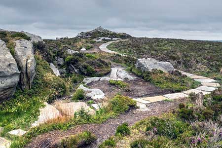
Turn left and follow the access drive south to Whittondean Farm. Follow the track right after passing the farm soon leaving the track on a path off to the right. The path heads south soon passing Lordenshaws hillfort on your left. Continue ahead up the clear path to a small car park (grid ref. NZ053988). Pass through the car park and cross the road to the paved path opposite. The onward path is easy to follow and is paved in places to protect against further erosion. The path climbs to The Beacon followed by a short descent and an ascent onto Dove Crag. A short descent leads to the final climb to Simonside (grid ref. NZ024987). This section of the walk offers a magnificent view north to The Cheviots.
A steep descent from Simonside leads down to a track with adjacent information board (grid ref. NZ022988). Turn right along the track and after 150 metres bear left onto a path through heather by a marker post. Continue downhill along the path which soon turns right. Continue along the path, go straight across a track, and follow the path into forest. The path continues north and exits the trees (grid ref. NZ024999). The onward path enters a field and runs parallel to the edge of the forest on your right. Follow the path to the end of the forest (by a big tree) and bear half right to a track keeping the farm on your right.
Turn right along the track into Great Tosson. Reaching the road, continue ahead passing the remains of Tosson Tower on your right. Just past a parking area, fork left and follow the lane to a T-junction. Turn left and at the next junction head right along a no-through road. Follow the lane which soon becomes a track and follow it around a right-hand bend. Cross the River Coquet and almost immediately take the footpath on the right across a field. Continue ahead to a track and turn right. Follow the track beside the river back into Rothbury. Reaching a footbridge over the river, turn right to return to the car park or left to explore Rothbury.
Other walks nearby
| Walk 2148 | Simonside Circular | easy/mod | 4.7 miles |
| Walk 1202 | The Simonside Hills near Rothbury | easy | 4.5 miles |
| Walk 2163 | Darden Pike & Darden Lough | easy/mod | 4.2 miles |
| Walk 3085 | The Dodd & Wether Cairn | moderate | 9.5 miles |
| Walk 1805 | An introduction to the Breamish Valley | easy | 2.0 miles |
| Walk 1766 | Cushat Law and Bloodybush Edge from Hartside | mod/hard | 12.5 miles |
| Walk 2282 | Bewick Moor | moderate | 9.1 miles |
| Walk 1200 | Windy Gyle | moderate | 7.5 miles |
| Walk 1763 | Mozie Law & Windy Gyle | moderate | 8.2 miles |
| Walk 1764 | The Cheviot from Langleeford | mod/hard | 8.2 miles |
Recommended Books & eBooks
Hadrian's Wall Path
 Hadrians Wall Path guidebook to walk the 84 mile National Trail. Described in both directions, the main description is west to east between Bowness-on-Solway and Wallsend, Newcastle, with extensions to Maryport and South Shields. With extensive historical information related to this World Heritage site and separate 1:25,000 OS map booklet included.
More information
Walking in Northumberland
 This guidebook contains detailed route descriptions for 36 day walks in Northumberland including the Cheviot Hills. The terrain varies from wild walks and craggy ascents to gentle riverside strolls. Each route ranges from 4 to 16 miles in length and there is the opportunity to link several walks together to create longer treks.
More information
Messaging & Social Media
Message Walking Britain and follow the latest news.

Mountain Weather
Stay safe on the mountains with detailed weather forecasts - for iOS devices or for Android devices.