Blagdon Lake
Somerset Walk
County/Area - Somerset
Author - Lou Johnson
Length - 5.7 miles / 9.3 km Ascent - 500 feet / 152 metres
Time - 3 hours 20 minutes Grade - easy/mod
Maps 

| Ordnance Survey Explorer 141 | Sheet Map | 1:25k | BUY |
| Anquet OS Explorer 141 | Digital Map | 1:25k | BUY |
| Ordnance Survey Explorer 154 | Sheet Map | 1:25k | BUY |
| Anquet OS Explorer 154 | Digital Map | 1:25k | BUY |
Walk Route Description
Click image to see photo description.
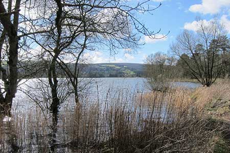
This North Somerset walk provides a rewarding circular walk around Blagdon Lake. The route starts from the village of Blagdon on the A368 southwest of Bristol. The undulating walk follows country lane and paths around the lake amidst the rolling Mendip Hills.
The start is the free car park on Station Road in Blagdon (grid ref. ST501592). After parking exit the car park and turn left and follow the lane signed to Blagdon Lake and Butcombe. Ignore side roads and keep ahead soon getting views of Blagdon Lake. Continue along the dam of the lake and take the first signed footpath on the right through a metal kissing gate. Follow the clear path beside the lake. The onward paths leaves the lakeside after 800 metres. Entering woodland, the waymarked path soon enters fields and continues with a hedge on your left before heading straight across a large field to a wall stile and lane by Bellevue Farm (grid ref. ST518604).
Turn left past a house to a road junction. Turn right and follow the winding lane to a crossroads. Go straight across (signed to Nempnett). At the next junction turn right and continue through Nempnett. At the next junction continue ahead ignoring Awkward Hill on the right. 300 metres beyond the junction turn right onto a path through a metal gate in the hedge (grid ref. ST527600). The path descends across fields and over stiles to a small wooden gate and a lane (grid ref. ST529593).
Turn left and keep to the right at the first junction. Take the first signed footpath on the right and continue close to the reservoir for two kilometres to Holt Farm. After a further 500 metres you reach a path junction (grid ref. ST510591). Bear left uphill to reach Grib Lane. Bear right and continue to the next junction. Turn right and continue to a junction (with a triangle of grass). Turn right up to the church and take the signed path to the left of the entrance and follow this back into Blagdon.
Other walks nearby
| Walk 1662 | Wavering Down & Crook Peak from Winscombe | easy/mod | 6.0 miles |
| Walk 3666 | West Mendip Way & Old Ditch from Rodney Stoke | moderate | 7.0 miles |
| Walk 3332 | Cameley & Hinton Blewett from Litton | easy | 5.6 miles |
| Walk 2172 | Ebbor Gorge & Priddy from Wookey Hole | easy/mod | 6.3 miles |
| Walk 2184 | Ebbor Gorge from Wookey Hole | easy/mod | 3.0 miles |
| Walk 2426 | Wraxall circular from Tyntesfield | easy | 3.2 miles |
| Walk 1346 | Priddy, Ebbor Gorge & Wookey Hole from Wells | moderate | 13.5 miles |
| Walk 2201 | Historic Wells Circular | easy | 1.5 miles |
| Walk 1275 | Wells, North Wootton & Worminster | moderate | 9.5 miles |
| Walk 1518 | Brunel's masterpieces and the Avon Gorge | easy | 4.0 miles |
Recommended Books & eBooks
No suggestions for this area.Messaging & Social Media
Message Walking Britain and follow the latest news.

Mountain Weather
Stay safe on the mountains with detailed weather forecasts - for iOS devices or for Android devices.