Walk 2097 - printer friendly version
Blagdon Lake Walk
Author - Lou Johnson
Length - 5.7 miles / 9.3 km
Ascent - 500 feet / 152 metres
Grade - easy/mod
Start - OS grid reference ST501592
Lat 51.3296950 + Long -2.7175910
Postcode BS40 7TG (approx. location only)
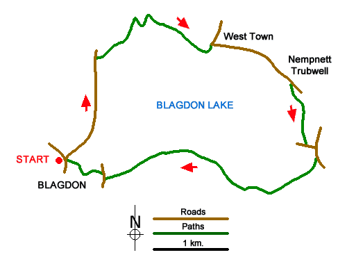
This North Somerset walk provides a rewarding circular walk around Blagdon Lake. The route starts from the village of Blagdon on the A368 southwest of Bristol. The undulating walk follows country lane and paths around the lake amidst the rolling Mendip Hills.
The start is the free car park on Station Road in Blagdon (grid ref. ST501592). After parking exit the car park and turn left and follow the lane signed to Blagdon Lake and Butcombe. Ignore side roads and keep ahead soon getting views of Blagdon Lake. Continue along the dam of the lake and take the first signed footpath on the right through a metal kissing gate. Follow the clear path beside the lake. The onward paths leaves the lakeside after 800 metres. Entering woodland, the waymarked path soon enters fields and continues with a hedge on your left before heading straight across a large field to a wall stile and lane by Bellevue Farm (grid ref. ST518604).
Turn left past a house to a road junction. Turn right and follow the winding lane to a crossroads. Go straight across (signed to Nempnett). At the next junction turn right and continue through Nempnett. At the next junction continue ahead ignoring Awkward Hill on the right. 300 metres beyond the junction turn right onto a path through a metal gate in the hedge (grid ref. ST527600). The path descends across fields and over stiles to a small wooden gate and a lane (grid ref. ST529593).
Turn left and keep to the right at the first junction. Take the first signed footpath on the right and continue close to the reservoir for two kilometres to Holt Farm. After a further 500 metres you reach a path junction (grid ref. ST510591). Bear left uphill to reach Grib Lane. Bear right and continue to the next junction. Turn right and continue to a junction (with a triangle of grass). Turn right up to the church and take the signed path to the left of the entrance and follow this back into Blagdon.
Messaging & Social Media
Message Walking Britain and follow the latest news.

Mountain Weather
Stay safe on the mountains with detailed weather forecasts - for iOS devices or for Android devices.