Walk 2143 - printer friendly version
Whitbarrow & Lord's Seat Walk
Author - Lou Johnson
Length - 5.4 miles / 8.8 km
Ascent - 900 feet / 273 metres
Grade - easy/mod
Start - OS grid reference SD453896
Lat 54.299068 + Long -2.8420064
Postcode LA8 8DB (approx. location only)
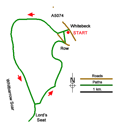
A circular walk in the outlying fells of the Lake District from Whitebeck on the A5074 southeast of Windermere. The route explores Whitbarrow a ridge of limestone that is now a nature reserve due to its varied fauna and flora. The walk offers wonderful walking in a beautiful landscape with a panoramic view from Lord's Seat which includes Morecambe Bay and the Lake District Fells.
The start is the layby opposite the Lyth Valley (grid ref. SD453896) on the A5074. After parking take the signed footpath opposite the restaurant. After 100 metres the path forks. Bear right and continue up to Whitbarrow Lane. Turn right along a track as it loops around Whitbarrow and continue for 1.5 kilometres to where the byway bears right (grid ref. SD436895). Continue ahead following the blue waymark. The path is initially level but beyond Fell Edge the path rises more steeply to cross a stile at the top of the crags.
The next landmark is solitary boulder on the skyline after which the path aims towards a plantation. Cross the stile over a wall and continue with along the wall to reach a stile (grid ref. SD443875). Do not cross the stile and continue to Lord's Seat and it's cairn (grid ref. SD442870). The summit is a perfect place to spend some time enjoying the extensive view to the coast and mountains. To continue, return to the stile and cross to follow a path through trees. After 150 metres turn left (yellow waymark) and continue along the path for 750 metres to pass through a gate (grid ref. SD449811). Continue through Township Plantation, ignoring side paths left and right, to reach a wall. Bear left along the wall and pass through a gate into a pasture (grid ref. SD448888).
Continue along the path (with wall on your right) to reach the village of Row and a road (grid ref. SD451892). Bear right along the road and turn sharp left along the first track on the left. This track leads back to the path used at the beginning of the walk. Bear right and continue back to the A5074 and the start of the walk.
Messaging & Social Media
Message Walking Britain and follow the latest news.

Mountain Weather
Stay safe on the mountains with detailed weather forecasts - for iOS devices or for Android devices.