Whitbarrow & Lord's Seat from Whitebeck
Lake District Walk
Nat Park - Lake District - Lake District Lesser Fells
County/Area - Cumbria
Author - Lou Johnson
Length - 5.4 miles / 8.8 km Ascent - 900 feet / 273 metres
Time - 3 hours 40 minutes Grade - easy/mod
Maps 

| Ordnance Survey Explorer OL7 | Sheet Map | 1:25k | BUY |
| Anquet OS Explorer OL7 | Digital Map | 1:25k | BUY |
Walk Route Description
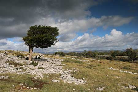
Click image to see photo description.
A circular walk in the outlying fells of the Lake District from Whitebeck on the A5074 southeast of Windermere. The route explores Whitbarrow a ridge of limestone that is now a nature reserve due to its varied fauna and flora. The walk offers wonderful walking in a beautiful landscape with a panoramic view from Lord's Seat which includes Morecambe Bay and the Lake District Fells.
The start is the layby opposite the Lyth Valley (grid ref. SD453896) on the A5074. After parking take the signed footpath opposite the restaurant. After 100 metres the path forks. Bear right and continue up to Whitbarrow Lane. Turn right along a track as it loops around Whitbarrow and continue for 1.5 kilometres to where the byway bears right (grid ref. SD436895). Continue ahead following the blue waymark. The path is initially level but beyond Fell Edge the path rises more steeply to cross a stile at the top of the crags.
The next landmark is solitary boulder on the skyline after which the path aims towards a plantation. Cross the stile over a wall and continue with along the wall to reach a stile (grid ref. SD443875). Do not cross the stile and continue to Lord's Seat and it's cairn (grid ref. SD442870). The summit is a perfect place to spend some time enjoying the extensive view to the coast and mountains. To continue, return to the stile and cross to follow a path through trees. After 150 metres turn left (yellow waymark) and continue along the path for 750 metres to pass through a gate (grid ref. SD449811). Continue through Township Plantation, ignoring side paths left and right, to reach a wall. Bear left along the wall and pass through a gate into a pasture (grid ref. SD448888).
Continue along the path (with wall on your right) to reach the village of Row and a road (grid ref. SD451892). Bear right along the road and turn sharp left along the first track on the left. This track leads back to the path used at the beginning of the walk. Bear right and continue back to the A5074 and the start of the walk.
Other walks nearby
| Walk 3451 | Underbarrow, Lord's Lot and Crossthwaite | easy/mod | 5.6 miles |
| Walk 2721 | Scout Scar Limestone Ridge | easy/mod | 5.0 miles |
| Walk 3452 | Ghyll Head & Strawberry Bank Circular | moderate | 7.6 miles |
| Walk 1148 | Scout Scar from Sizergh | moderate | 11.0 miles |
| Walk 3199 | Whitbarrow Fell from Mill Side | moderate | 7.0 miles |
| Walk 3549 | Whitbarrow Scar from Mill Side | moderate | 6.5 miles |
| Walk 1045 | Levens Bridge to Kendal | easy/mod | 11.5 miles |
| Walk 3234 | Gummers How via Chapel House Wood, South Lake District | easy/mod | 5.5 miles |
| Walk 1417 | Astley's Plantation & Simpson's Ground | easy/mod | 7.5 miles |
| Walk 1555 | Brunt Knott from Staveley | easy/mod | 7.0 miles |
Recommended Books & eBooks
Lake District: High Level and Fell Walks
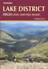 This guidebook describes 30 graded fell walks on the ridges and high peaks of the English Lake District, the UK's most popular national park. Reaching some of England's finest and highest mountain scenery, this guide leads readers to classic horseshoes and traditional ascents as well as lesser-known routes to quieter summits.
More information
Lake District: Low Level and Lake Walks
 This guidebook describes 30 of the best low-level walks in the Lake District. From delightful wooded glades and sparkling tarns, to waterfalls and glacier-carved valleys towered over by craggy mountains. The walks described aim to seek out the best walking that the lower areas of the Lake District have to offer.
More information
Messaging & Social Media
Message Walking Britain and follow the latest news.

Mountain Weather
Stay safe on the mountains with detailed weather forecasts - for iOS devices or for Android devices.