Walk 2163 - printer friendly version
Darden Pike & Darden Lough Walk
Author - Lou Johnson
Length - 4.2 miles / 6.8 km
Ascent - 800 feet / 242 metres
Grade - easy/mod
Start - OS grid reference NY958981
Lat 55.2770220 + Long -2.0676570
Postcode NE65 7AT (approx. location only)
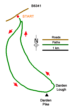
Darden Pike and the nearby Darden Lough provide a rewarding walk in the Northumberland National Park. Darden Pike (374 m.) is a rounded hill located on the south side of the B6341 between Elsdon and Hepple and despite its modest height offers a wide-ranging view. Sitting in a hollow slightly lower is Darden Lough which adds a patch of watery blue to the wild moorland.
The start is a small layby (grid ref. NY958981) on the south side of the B6341 with an adjacent information board and footpath fingerpost (signed Darden Lough). After parking join the path which goes half right and descend briefly through a field to reach a gate with yellow waymark pointing left. Ignore this path and continue ahead for 350 metres to reach a fork (grid ref. NY959977). Veer right here and follow the sign 'Waymarked Circuit via Darden Lough'. The path, wet in places, climbs steadily in an arc to reach Darden Pike (grid ref. NY968955). The summit has a trig column and cairn. and the best view of the walk, which includes nearby Darden Lough.
Top continue descend slight to the shore of Darden Lough. Beyond the Lough the path bear left and follows a grassy track marked by white topped posts. The route descends across Miller's Moss with some patches of wet ground. The route continues downhill to the gate (grid ref. NY959979) from where you return to the layby.
Messaging & Social Media
Message Walking Britain and follow the latest news.

Mountain Weather
Stay safe on the mountains with detailed weather forecasts - for iOS devices or for Android devices.