Darden Pike & Darden Lough
Northumberland Walk
Nat Park - Northumberland
County/Area - Northumberland County
Author - Lou Johnson
Length - 4.2 miles / 6.8 km Ascent - 800 feet / 242 metres
Time - 2 hours 50 minutes Grade - easy/mod
Maps 

| Ordnance Survey Explorer OL42 | Sheet Map | 1:25k | BUY |
| Anquet OS Explorer OL42 | Digital Map | 1:25k | BUY |
Walk Route Description
Click image to see photo description.
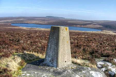
Darden Pike and the nearby Darden Lough provide a rewarding walk in the Northumberland National Park. Darden Pike (374 m.) is a rounded hill located on the south side of the B6341 between Elsdon and Hepple and despite its modest height offers a wide-ranging view. Sitting in a hollow slightly lower is Darden Lough which adds a patch of watery blue to the wild moorland.
The start is a small layby (grid ref. NY958981) on the south side of the B6341 with an adjacent information board and footpath fingerpost (signed Darden Lough). After parking join the path which goes half right and descend briefly through a field to reach a gate with yellow waymark pointing left. Ignore this path and continue ahead for 350 metres to reach a fork (grid ref. NY959977). Veer right here and follow the sign 'Waymarked Circuit via Darden Lough'. The path, wet in places, climbs steadily in an arc to reach Darden Pike (grid ref. NY968955). The summit has a trig column and cairn. and the best view of the walk, which includes nearby Darden Lough.
Top continue descend slight to the shore of Darden Lough. Beyond the Lough the path bear left and follows a grassy track marked by white topped posts. The route descends across Miller's Moss with some patches of wet ground. The route continues downhill to the gate (grid ref. NY959979) from where you return to the layby.
Other walks nearby
| Walk 2148 | Simonside Circular | easy/mod | 4.7 miles |
| Walk 3085 | The Dodd & Wether Cairn | moderate | 9.5 miles |
| Walk 1202 | The Simonside Hills near Rothbury | easy | 4.5 miles |
| Walk 2095 | Simonside Hills & Rothbury | moderate | 7.9 miles |
| Walk 1200 | Windy Gyle | moderate | 7.5 miles |
| Walk 1763 | Mozie Law & Windy Gyle | moderate | 8.2 miles |
| Walk 1766 | Cushat Law and Bloodybush Edge from Hartside | mod/hard | 12.5 miles |
| Walk 2169 | Chew Green & Upper Coquet Valley | easy/mod | 5.8 miles |
| Walk 2251 | Yearning Saddle & Brownhart Law | moderate | 7.8 miles |
| Walk 1805 | An introduction to the Breamish Valley | easy | 2.0 miles |
Recommended Books & eBooks
Walking in Northumberland
 This guidebook contains detailed route descriptions for 36 day walks in Northumberland including the Cheviot Hills. The terrain varies from wild walks and craggy ascents to gentle riverside strolls. Each route ranges from 4 to 16 miles in length and there is the opportunity to link several walks together to create longer treks.
More information
Hadrian's Wall Path
 Hadrians Wall Path guidebook to walk the 84 mile National Trail. Described in both directions, the main description is west to east between Bowness-on-Solway and Wallsend, Newcastle, with extensions to Maryport and South Shields. With extensive historical information related to this World Heritage site and separate 1:25,000 OS map booklet included.
More information
Messaging & Social Media
Message Walking Britain and follow the latest news.

Mountain Weather
Stay safe on the mountains with detailed weather forecasts - for iOS devices or for Android devices.