Sherborne Park & Oborne
Dorset Walk
County/Area - Dorset
Author - Lou Johnson
Length - 6.0 miles / 9.8 km Ascent - 550 feet / 167 metres
Time - 3 hours 30 minutes Grade - easy/mod
Maps 

| Ordnance Survey Explorer 129 | Sheet Map | 1:25k | BUY |
| Anquet OS Explorer 129 | Digital Map | 1:25k | BUY |
Walk Route Description
Click image to see photo description.
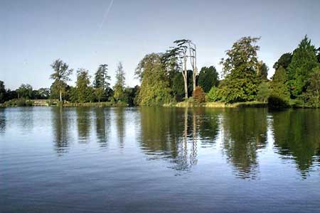
A circular walk from Sherborne (Dorset) exploring Sherborne Park and surrounding countryside. The undulating route follows well-used signed paths. After crossing Sherborne Park the walk turns north to pass through the village of Oborne. Turning south the route returns to Sherborne along a green lane. If time permits, you can also visit Sherborne Castle and Old Sherborne Castle (English Heritage) and explore the attractive town.
The walk starts from Sherborne Railway Station (grid ref. ST640162). There is also car parking nearby. If arriving by train walk to the eastern end of the platforms to the level crossing and turn right along South Street. Continue to a T-junction and cross the road to a metal kissing gate opposite. Once through the gate, turn left on a rising grassy track. Continue past the Slopes Viewpoint to enter farmland. The path continues with a hedge on your left across large field to a junction of tracks (grid ref. ST650150).
Continue ahead to the immediate right of a group of trees. Stay on the track for two kilometres. 150 metres beyond a group of buildings on the left (The Camp) you reach a junction (grid ref. ST667161). Continue straight ahead and after 200 metres turn left onto a path heading north through the Deer Park. Maintain direction roughly northwards for 1300 metres towards Pinford Farm. The path passes to the left of the farm and joins a driveway. Turn left, pass between trees, and turn right and cross a field. The path leads to Pinfold Lane (grid ref. ST662173).
Take the signed path opposite into woodland. The path soon exits the trees to cross a field. Continue along the waymarked route across two more fields, pass under the railway and continue to the A30. Cross with great care and turn right. Take the next road on the left (signed to Oborne). After 500 metres, turn left (by a post box on the right) and continue past St Cuthbert's Church on your right. When the tarmac ends continue ahead to join a green lane (Underdown Lane) enclosed with hedges. Follow the lane as it bends left and continue to the A30.
Cross the A30 to the signed bridleway opposite. Follow this to reach the B3145 (Oborne Road). Bear right and continue to a road junction. Turn left into New Road (signed to the Railway Station). Cross the railway and take the first signed footpath on the right (grid ref. ST645165). Follow the path Purlieu Meadow to reach a road. Turn right to retrace your steps back to Sherborne Railway Station.
Other walks nearby
| Walk 3454 | Corton Denham and Cadbury Castle | easy/mod | 6.7 miles |
| Walk 1328 | Minterne Magna & the Cerne Giant | easy/mod | 6.8 miles |
| Walk 2733 | Plush & Wessex Ridgeway | easy/mod | 4.7 miles |
| Walk 3673 | Rawlsbury Camp, Lower Ansty, Hilton & Bulbarrow | easy/mod | 7.2 miles |
| Walk 1868 | Plush from Piddletrenthide | easy/mod | 6.0 miles |
| Walk 3695 | Hambledon Hill & Hod Hill from Shroton | easy/mod | 6.0 miles |
| Walk 3304 | Pennard Hill from Pylle | moderate | 10.0 miles |
| Walk 3265 | Eggardon Hill from Powerstock | easy/mod | 6.3 miles |
| Walk 3499 | West Compton & North Wootton from Pilton | easy/mod | 7.5 miles |
| Walk 3629 | Eggardon Hill from Loders | moderate | 8.4 miles |
Recommended Books & eBooks
Walking the Jurassic Coast
 This guidebook includes 30 walks on the Jurassic Coast of Devon and Dorset. Covering the coast between Exmouth and Bournemouth, these delightful routes range from 3 to 16 miles (5 to 24km), exploring and explaining the spectacular geology of this World Heritage area with clear, easily understood descriptions, cross-sections and timelines.
More information
Messaging & Social Media
Message Walking Britain and follow the latest news.

Mountain Weather
Stay safe on the mountains with detailed weather forecasts - for iOS devices or for Android devices.