Walk 2189 - printer friendly version
Sherborne Park & Oborne Walk
Author - Lou Johnson
Length - 6.0 miles / 9.8 km
Ascent - 550 feet / 167 metres
Grade - easy/mod
Start - OS grid reference ST640162
Lat 50.9441070 + Long -2.5137859
Postcode DT9 3LR (approx. location only)
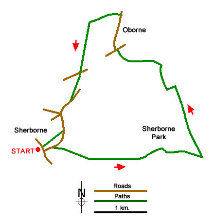
A circular walk from Sherborne (Dorset) exploring Sherborne Park and surrounding countryside. The undulating route follows well-used signed paths. After crossing Sherborne Park the walk turns north to pass through the village of Oborne. Turning south the route returns to Sherborne along a green lane. If time permits, you can also visit Sherborne Castle and Old Sherborne Castle (English Heritage) and explore the attractive town.
The walk starts from Sherborne Railway Station (grid ref. ST640162). There is also car parking nearby. If arriving by train walk to the eastern end of the platforms to the level crossing and turn right along South Street. Continue to a T-junction and cross the road to a metal kissing gate opposite. Once through the gate, turn left on a rising grassy track. Continue past the Slopes Viewpoint to enter farmland. The path continues with a hedge on your left across large field to a junction of tracks (grid ref. ST650150).
Continue ahead to the immediate right of a group of trees. Stay on the track for two kilometres. 150 metres beyond a group of buildings on the left (The Camp) you reach a junction (grid ref. ST667161). Continue straight ahead and after 200 metres turn left onto a path heading north through the Deer Park. Maintain direction roughly northwards for 1300 metres towards Pinford Farm. The path passes to the left of the farm and joins a driveway. Turn left, pass between trees, and turn right and cross a field. The path leads to Pinfold Lane (grid ref. ST662173).
Take the signed path opposite into woodland. The path soon exits the trees to cross a field. Continue along the waymarked route across two more fields, pass under the railway and continue to the A30. Cross with great care and turn right. Take the next road on the left (signed to Oborne). After 500 metres, turn left (by a post box on the right) and continue past St Cuthbert's Church on your right. When the tarmac ends continue ahead to join a green lane (Underdown Lane) enclosed with hedges. Follow the lane as it bends left and continue to the A30.
Cross the A30 to the signed bridleway opposite. Follow this to reach the B3145 (Oborne Road). Bear right and continue to a road junction. Turn left into New Road (signed to the Railway Station). Cross the railway and take the first signed footpath on the right (grid ref. ST645165). Follow the path Purlieu Meadow to reach a road. Turn right to retrace your steps back to Sherborne Railway Station.
Messaging & Social Media
Message Walking Britain and follow the latest news.

Mountain Weather
Stay safe on the mountains with detailed weather forecasts - for iOS devices or for Android devices.