Empingham & Exton
Rutland Walk
County/Area - Rutland
Author - Lou Johnson
Length - 9.0 miles / 14.6 km Ascent - 500 feet / 152 metres
Time - 5 hours 0 minutes Grade - easy/mod
Maps 

| Ordnance Survey Explorer 234 | Sheet Map | 1:25k | BUY |
| Anquet OS Explorer 234 | Digital Map | 1:25k | BUY |
Walk Route Description
Click image to see photo description.
Starting from Empingham this walk includes a section alongside Rutland Water and the villages of Whitwell and Extion. The majority of the route is across pleasant countryside and passes the lakes at Fort Henry. The walk follows sections of the Rutland Round and Viking Way.
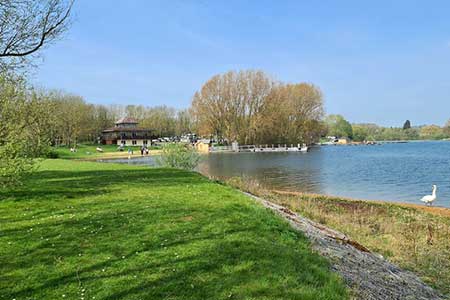
The walk starts from the crossroads in the centre of Empingham on Main Street (grid ref. SK950087). On street parking is available nearby. After parking walk west along Main Street (signed to Oakham/A6060). Reaching the A606, turn left and immediately right into Nook Lane. After 150 metres turn right onto a signed footpath running between houses. The path heads half-left across a field to enter woodland. Exiting the trees, the path then runs beside more woodland to reach the access road to Rutland Water Beach car park.
Walk through the car park and head towards the reservoir passing an information board. Continue along the Rutland Round path to Whitwell Creek. Continue along the good path to the top of the creek. At the next path junction keep right and continue to Bull Brig Lane (grid ref. SK924086). Turn right and follow the lane towards Whitwell Village. Approaching the village, fork right towards the church. Follow the road as it bends right in front of the church and after passing a thatched cottage on the left, bear left down a narrow lane to the A606.
Cross the road and turn right. Just before reaching The Noel pub, turn left onto a signed footpath (signed Viking Way). The path heads north across fields to Exton Road at a junction (grid ref. SK928105). Go straight across to take the road signed to Exton. Follow the road for 700 metres and the turn right into New Field Road. Note there is no street name, but it is signed as a no through road just before an area of grass. Continue to the end of the tarmac, cross a cattle grid, and follow a clear track. Continue ahead at a crossroads to arrive at Fort Henry Lake. Fort Henry is a folly which can be seen on the left.
Just after the lake, turn right to join a footpath heading south with Lower Lake on your right. Continue south soon joining a path with a hedge on your left. Continue to the end of a plantation on your left, bear right across the stream, then go left and follow the path to exit across a stile onto a road. Turn left and take the first signed path on the right across a stile. The path maintains direction across fields to reach a path junction and stile after just over a kilometre (grid ref. SK949094). Cross the stile and bear left. The path continues beside woodland (on your right) to reach a road. Turn left back into the centre Empingham.
Other walks nearby
| Walk 2323 | Hambleton Peninsula circular | easy | 4.9 miles |
| Walk 3628 | Morcott & Harringworth Circular | easy/mod | 7.2 miles |
| Walk 2447 | Braunston-in-Rutland Circular | easy | 5.3 miles |
| Walk 3284 | Bowthorpe Oak from Witham on the Hill | easy/mod | 8.0 miles |
| Walk 2913 | Stockerston, Great Easton & Gretton from Lyddington | moderate | 15.0 miles |
| Walk 2831 | Cranoe, Medbourne & Blaston from Hallaton | moderate | 11.5 miles |
| Walk 2927 | Hallaton, Glooston & Rolleston from Tugby | moderate | 12.5 miles |
| Walk 1443 | Burrough Hill & Somerby from Twyford | moderate | 11.0 miles |
| Walk 1708 | Lowesby and South Croxton | easy/mod | 7.0 miles |
| Walk 3425 | Rolleston from Billesdon | easy | 5.3 miles |
Recommended Books & eBooks
No suggestions for this area.Messaging & Social Media
Message Walking Britain and follow the latest news.

Mountain Weather
Stay safe on the mountains with detailed weather forecasts - for iOS devices or for Android devices.