Draynes Bridge & Siblyback Lake
Cornwall AONB Walk
Region - Cornwall AONB
County/Area - Cornwall
Author - Lou Johnson
Length - 5.0 miles / 8.1 km Ascent - 500 feet / 152 metres
Time - 3 hours 0 minutes Grade - easy/mod
Maps 

| Ordnance Survey Explorer 109 | Sheet Map | 1:25k | BUY |
| Anquet OS Explorer 109 | Digital Map | 1:25k | BUY |
Walk Route Description
Click image to see photo description.
Walk from Draynes Bridge explores the area north to Siblyback Lake. The route passes through villages, and countryside typical of the area. The walk also passes King Doniert's Stone and follows a path beside Siblyback Lake, a reservoir that feeds the River Fowey.
The start is the car park at Draynes Bridge (grid ref. SX228690) where refreshments are available in season. After parking, exit the car park and turn left to cross Draynes Bridge. At the T-junction, turn right and continue to a junction. Turn right and them immediately left. Signed to Lampretton. Continue along the lane through Redgate and take the first lane on the left towards Treworrick Farm. Pass Lower and Upper farms and just before the lane bends right, fork left up a track. After 20 metres turn left onto a green lane. Follow this for 400 metres to a road.
Turn right soon passing King Doniert's Stone on your right where an information board provides details of its history. Continue along the lane to the next junction and turn left (signed no through road). The lane descends gently into a valley. Just before a small bridge with green railings, turn right along a signed footpath (grid ref. SX236694). The path follows a steam and crosses two footbridges to exit into the village of Common Moor. Pass the village Hall on your right and at a T-junction turn left. Follow the lane to the end of the tarmac where you join a track (grid ref. SX240695).
Stay on the track for 300 metres and turn left across a wooden bridge. Entering a field, turn right and follow the path with a wall on your right. Continue along the wall to a ladder stile on the right. Cross the stile and walk half-left aiming for the top corner of the field. Pass through a gap in a wall, bear left and walk between Crylla Farm on your right and a house on your left. Cross a stile and follow path ahead to another stile. Then head downhill to a gate and a lane.
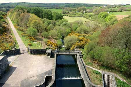
Turn left and after a few metres fork left off the lane to join the path that follows the shoreline of Siblyback Lake. Note if you need refreshments, turn left up the lane to a café. Stay on the clear path to reach the dam. Here a short diversion onto the dam offers an excellent view of the Lake and the Fowey Valley. After enjoying the view, retrace you steps to the end of the dame and turn right down a path that soon joins an access drive. Continue to a lane and turn left back to Draynes Bridge.
If time permits a short additional walk can be added to the route above. Take the footpath opposite the car park and follow path beside the River Fowey to view Golitha Falls and return by the same route.
Other walks nearby
| Walk 3606 | Berry Down from St Neot | easy/mod | 5.6 miles |
| Walk 1883 | Advent Church | easy | 5.2 miles |
| Walk 1808 | Brown Willy, exploring Cornwall's highest Tors | easy/mod | 4.0 miles |
| Walk 3279 | Tors of Bodmin Moor | moderate | 10.0 miles |
| Walk 1031 | Polruan & Lanteglos Church | easy/mod | 4.3 miles |
| Walk 2342 | Gribbin Head & Polkerris from Polruan | moderate | 8.5 miles |
| Walk 1030 | Fowey & Gribbin Head | moderate | 8.0 miles |
| Walk 1029 | Tintagel to Boscastle | moderate | 9.0 miles |
| Walk 3264 | Port Quin & Port Isaac Circular | easy/mod | 5.7 miles |
| Walk 2730 | St Gennys & Castle Point from Crackington Haven | easy/mod | 3.0 miles |
Recommended Books & eBooks
Walking in Cornwall
 This guidebook includes routes to 40 day walks in Cornwall. From short, easy strolls to longer, wilder routes, there is plenty to appeal to both families and experienced walkers. The walks explore the interior and coasts, including walks through picturesque villages, old tin-mining areas and the Lizard and Land's End Peninsulas.
More information
Messaging & Social Media
Message Walking Britain and follow the latest news.

Mountain Weather
Stay safe on the mountains with detailed weather forecasts - for iOS devices or for Android devices.