Brown Willy, exploring Cornwall's highest Tors
Cornwall AONB Walk
Region - Cornwall AONB
County/Area - Cornwall
Author - Lou Johnson
Length - 4.0 miles / 6.5 km Ascent - 1100 feet / 333 metres
Time - 3 hours 10 minutes Grade - easy/mod
Maps 

| Ordnance Survey Explorer 109 | Sheet Map | 1:25k | BUY |
| Anquet OS Explorer 109 | Digital Map | 1:25k | BUY |
| Ordnance Survey Landranger 201 | Sheet Map | 1:50k | BUY |
| Anquet OS Landranger 201 | Digital Map | 1:50k | BUY |
| Ordnance Survey Landranger 202 | Sheet Map | 1:50k | BUY |
| Anquet OS Landranger 202 | Digital Map | 1:50k | BUY |
Walk Route Description
Click image to see photo description.
This relatively easy exploration of Cornwall's highest land can easily be accomplished in a couple of hours and provides a good introduction to the moorland spine to this the most western County of Britain. The easiest approach is from Camelford which lies astride the A39. From this pleasant town head southeast on the minor road to Poldue Downs where ample car parking is available at the end of the road (grid ref. SX138818).
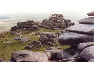
From the car park continue south-east following the clear path that leads to the summit of Rough Tor, which forms the right hand end of the rock strewn ridge ahead. Roughly half way to the summit leave the main path and head west to the rocky crown of Showery Tor - the summit at the left hand end of the ridge. There is a path but if you miss it the terrain provides easy off-path walking.
Cresting the ridge Cornwall's highest summit, Brown Willy, comes into view offering a less exciting prospect than the Tor just climbed. Taking the feint path south and keeping to the western side of the stream, you will reach a more defined path that leads onwards and upwards to Cornwall's highest land. The summit is rather uninspiring but it does offer good views in all directions. The warning notices should be heeded as there are Adders in this area.
Return by the same path you used on the ascent to drop down to the stream. However rather than return by way of Showery Tor head gently upwards to the dramatic rocks that mark the summit of Rough Tor where there is plenty scope for scrambling on the rocks. All that remains is a steady descent northwest back to the car park. If time permits a short detour south along the banks of the stream just prior to the car park will reveal a monument to a nineteenth century murder victim - a rather gruesome end to a very pleasant short Cornish excursion.
Other walks nearby
| Walk 1883 | Advent Church | easy | 5.2 miles |
| Walk 1029 | Tintagel to Boscastle | moderate | 9.0 miles |
| Walk 3606 | Berry Down from St Neot | easy/mod | 5.6 miles |
| Walk 2730 | St Gennys & Castle Point from Crackington Haven | easy/mod | 3.0 miles |
| Walk 2731 | Cambeak & Crackington Haven | easy/mod | 4.3 miles |
| Walk 2247 | Draynes Bridge & Siblyback Lake | easy/mod | 5.0 miles |
| Walk 3264 | Port Quin & Port Isaac Circular | easy/mod | 5.7 miles |
| Walk 1076 | Dizzard Point & Crackington Haven | moderate | 8.0 miles |
| Walk 3755 | Dizzard Point, Millook from Penhalt Cliff | moderate | 6.0 miles |
| Walk 2462 | The Rumps & Pentire Point | easy/mod | 4.0 miles |
Recommended Books & eBooks
Walking in Cornwall
 This guidebook includes routes to 40 day walks in Cornwall. From short, easy strolls to longer, wilder routes, there is plenty to appeal to both families and experienced walkers. The walks explore the interior and coasts, including walks through picturesque villages, old tin-mining areas and the Lizard and Land's End Peninsulas.
More information
Messaging & Social Media
Message Walking Britain and follow the latest news.

Mountain Weather
Stay safe on the mountains with detailed weather forecasts - for iOS devices or for Android devices.