Grassholme Reservoir from Middleton-in-Teesdale
North Pennines Walk
Region - North Pennines
County/Area - Durham
Author - Lou Johnson
Length - 8.2 miles / 13.3 km Ascent - 1100 feet / 333 metres
Time - 5 hours 10 minutes Grade - moderate
Maps 

| Ordnance Survey Explorer OL31 | Sheet Map | 1:25k | BUY |
| Anquet OS Explorer OL31 | Digital Map | 1:25k | BUY |
Walk Route Description
Click image to see photo description.
Grassholme Reservoir is the main objective of this walk from Middleton-in-Teesdale. The route follows a section of the Pennine Way crossing higher ground, above Lunedale on your right, before descending into the valley to reach the shores of the Grassholme Reservoir. A path follows the edge of the reservoir to the dam. From here the walk continues across fields to join the Tees Railway Path to Lonton. From here a path beside the River Tees takes you back to the start.
The starting point is Market Place in Middleton-in-Teesdale (grid ref. NY947254) with several parking options nearby. The walk starts by descending Bridge Steet (signed to Scotch Corner). Cross the bridge over the River Tees and conti8nue uphill and turn first right (signed to Holwick). Within a few metres turn left onto the Pennine Way at the fingerpost. Follow the clear rising track which runs roughly parallel to a wall on your left. Pass through a gate and where the grassy track forks, keep right and continue up to another gate (grid ref. NY941243). Once through the gate bear right and follow a rising grassy path to another gate. Just after this gate you reach the highest point of the walk.
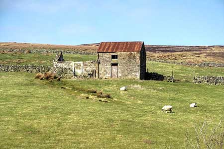
The Pennine Way then crosses a series of small fields, passes a ruined barn on your left (grid ref. NY926233). Just past the barn you join a more obvious track. Follow this for 150 metres to a junction and turn left. After a few metres bear right off the track and walk diagonally across two fields to a small group of trees. Join a track to pass Whythes Hill Farm and continue down to the B6276. Cross the road to the path opposite and continue down fields to Grassholme Farm and a lane (grid ref. NY916216).
Turn left down the lane and continue through a gate to reach Grassholme Reservoir. Cross the bridge, follow the lane steeply up hill and turn left through a metal kissing gate (signed South Shore Path). After just over two kilometres of pleasant walking along the reservoir you reach Teesside Sailing and Watersports Club. Continue ahead through the complex to reach the dam. Once on the dam, turn around and follow the tarmac access road to West Pasture Road (grid ref. NY948225).
Turn left along the road and continue to the first junction. Turn left over a wall stile (with adjacent post). Once in the field head half-right towards a wall. When entering the filed a gate is in sight. However, the second gate is out of sight and this needs to be located. Entering the next field, turn left and follow a wall on your left downhill. Pass through a gate, cross a small bridge over Eller Beck, turn right through a gate and head uphill to Westfield House. From here join the access drive and continue up to a lane (grid ref. NY957239). Turn right down the lane to reach a splendid railway viaduct. Cross the viaduct and continue along the Tees Railway Path. After 800 metres, turn right at a sign for Middleton. Continue to a road. Turn left and take the first signed path on the right by a fingerpost. The path heads half-left across a field and leads to the River Tees. Follow the river upstream towards the bridge crossed early in the walk. Reaching road, turn right and head uphill into Middleton-in-Teesdale.
Other walks nearby
| Walk 2228 | Romaldkirk Moor | easy/mod | 7.6 miles |
| Walk 3099 | High Force, Low Force and the River Tees | easy/mod | 7.5 miles |
| Walk 2157 | Romaldkirk & Cotherstone | easy | 5.0 miles |
| Walk 2170 | Eggleston & Mickleton from Romaldkirk | easy/mod | 5.8 miles |
| Walk 1553 | Hannah's Meadow, Baldersdale & Brown Rigg Moss | easy/mod | 8.0 miles |
| Walk 3424 | Cronkley Fell from Hanging Shaw | easy/mod | 7.0 miles |
| Walk 3526 | Hanging Shaw, Cronkley Scar, Low Force & High Force | moderate | 12.7 miles |
| Walk 3634 | Catterick Moss & Bollihope Carrs | moderate | 5.6 miles |
| Walk 2469 | Great Allotment & God's Bridge | moderate | 10.2 miles |
| Walk 2393 | Weardale Circular from Westgate | easy/mod | 6.4 miles |
Recommended Books & eBooks
Walking in the North Pennines
 This guidebook describes 50 day walks across the North Pennines, England's remotest Area of Outstanding Natural Beauty taking in parts of Cumbria, County Durham and Northumberland. Most of the routes are circular and they range from 5 to 14 miles, with something to suit all abilities. Route descriptions are accompanied by 1:50K OS mapping.
More information
Pennine Way Map Booklet
 Map of the 270 miles (435km) Pennine Way National Trail, between Edale in the Peak District and Kirk Yetholm in the Scottish Borders. This booklet is included with the Cicerone guidebook to the trail, and shows the full route on Ordnance Survey 1:25,000 maps. This popular long-distance route typically takes three weeks to complete.
More information
Messaging & Social Media
Message Walking Britain and follow the latest news.

Mountain Weather
Stay safe on the mountains with detailed weather forecasts - for iOS devices or for Android devices.