Cul Mor from Knockan Crag
Highland Walk
County/Area - Highland - Northern Highland
Author - Lou Johnson
Length - 8.5 miles / 13.8 km Ascent - 2550 feet / 773 metres
Time - 6 hours 50 minutes Grade - mod/hard
Maps 

| Ordnance Survey Explorer 439 | Sheet Map | 1:25k | BUY |
| Anquet OS Explorer 439 | Digital Map | 1:25k | BUY |
Walk Route Description
Click image to see photo description.
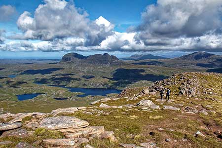
This outstanding walk explores Cul Mor, a complex hill of Torridonian sandstone that stands out from a landscape of lochs, lochans and other isolated hills which include Suilven and Canisp. The route, pathless in places visits Cul Mor's summit, a Corbett at 849 metres, together with the outlying minor tops of Bod a' Madhail (758 m.) and Creag nan Calman (828 m.). The hill is not worth walking if the weather is poor. Ideally wait for a day of clear blue skies so that you can fully enjoy the glorious panoramas that unfold during the walk.
The start is the Knockan Crag Visitor Centre car park on the south side of the A835 (grid ref. NC188091). After parking walk down to the main road and turn right. You soon reach a layby (an alternative start) on the left. Go through the gate at the far end of the layby to pick up a stalkers path which heads across wild moorland. After 300 metres pass through another gate and continue along the rising path which after two kilometres begins to be less obvious. The route is marked by occasional cairns heading up the east ridge of Meallan Diomhain (.609 metres). Reaching the summit, you can preview the ongoing route up Cul Mor's northeast ridge.
Leave the summit and head north downhill to cross the broad col of Fliuch Choire. Initially head uphill just west of north passing to the right of a small lochan (grid ref. NC169123). From here the grade steepens as you swing left up the ridge with a decent path to follow. As you gain height you have a superb view across to Suilven on your right. A final section through boulders takes you to the summit with its OS trig column.
To continue descend west for about half a kilometre and then swing northwest with the crags of Coire Gorm on your right. Continue to the end of the Bod a' Madhail spur to enjoy a wide-ranging panorama of lochans and the sea. Retrace you steps along the spur and head for the col between Cul Mor and Creag nan Calman. Continue up the ridge to the summit to enjoy a different perspective of this amazing watery landscape.
Retrace your steps back to the col and descend east into a grassy bowl. Walk roughly parallel with a burn on your left. After 800 metres of descent, the burn turns right. Cross the burn (approx. grid ref. NC168115) and head east to contour across the southern flank of Meallan Diomhain. After a kilometre of slow descent, you regain the outward route which is followed back to the start.
Other walks nearby
| Walk 2529 | Stac Pollaidh Circular | easy/mod | 2.8 miles |
| Walk 1017 | Stac Pollaidh | easy/mod | 3.0 miles |
| Walk 1319 | The Bone Caves of Inchnadamph | easy | 3.0 miles |
| Walk 3272 | Conival & Ben More Assynt from Inchnadamph | hard | 11.0 miles |
| Walk 1316 | Falls of Kirkaig | easy | 5.8 miles |
| Walk 1769 | Suilven (North-western approach) | hard | 12.0 miles |
| Walk 1317 | Sail Gharbh (Quinag) | moderate | 5.4 miles |
| Walk 1117 | Glas Bheinn & Eas a' Chual Aluinn (waterfall) | mod/hard | 8.5 miles |
| Walk 1312 | Achmelvich Bay and Alltanabradhan | easy | 3.0 miles |
| Walk 1018 | Beinn Ghobhlach | moderate | 6.0 miles |
Recommended Books & eBooks
Walking the Munros Vol 2 - Northern Highlands and the Cairngorms
 Guidebook to walking the northern Munros, covering the northern Highlands, the Cairngorms and the Isle of Skye. 70 routes are described, including those up Ben Macdui, Braeriach and Cairn Gorm. Routes range from 7 to 46km, requiring a fair level of fitness. The second of two guidebooks to walking Scotland's Munros: peaks higher than 3000ft.
More information
Great Mountain Days in Scotland
 Inspirational guidebook to 50 challenging routes for mountaineers, scramblers, hillwalkers and fell runners, many long enough to backpack over 2 days, especially in winter (12 to 25 miles). A mix of classic routes and unsung gems across Scotland from Galloway to the Outer Hebrides in widely differing wild landscapes. With customised OS mapping.
More information
Messaging & Social Media
Message Walking Britain and follow the latest news.

Mountain Weather
Stay safe on the mountains with detailed weather forecasts - for iOS devices or for Android devices.