Walk 2298 - printer friendly version
Porthgwarra & St Levan Circular Walk
Author - Lou Johnson
Length - 4.8 miles / 7.8 km
Ascent - 660 feet / 200 metres
Grade - easy
Start - OS grid reference SW371218
Lat 50.0381470 + Long -5.6729303
Postcode TR19 6JR (approx. location only)
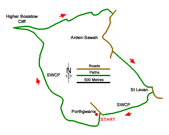
Walk from Porthgwarra which lies west of Porthcurno exploring the coast and countryside. The route follows a section of the South West Coast Path between St Levan and Higher Bosistow with rugged cliffs and fine coastal scenery. The inland section of the walk uses paths and tracks across the rolling countryside in this beautiful part of Cornwall.
The walk starts from the pay and display car park at Porthgwarra (grid ref. SW371218) which is reached by a lane from the B3315 at Polgigga. After parking walk towards the sea and just before the road bends sharp left join the South West Coast Path signed on the right. After a short climb, the path undulates along the cliff tops to round Gwennap Head with the National Coastwatch observation post a prominent feature. Stay on the coast for a further two kilometres to reach the promontory of Carn Les Boel which was the site of an Iron Age Fort (grid ref. SW357232).
After exploring the remains of the fort return to the coast path and go straight across. And head in an easterly direction to a gate (grid ref. SW363232). Continue along the enclosed path soon passing a house on the right. Continue ahead to the group of buildings at Higher Bosistow. Just before the buildings turn right onto a clear track. This track is followed for just under a kilometre to a lane. Turn right along the lane and continue past Arden-Sawah Farm on your right. Continue to where the lane bends right. ignore the overgrown footpath on the left and continue for another 100 metres to the next footpath on the left (grid ref. SW373228). The well-used path heads in a southeasterly direction across fields crossing stiles along the way. To help with navigation aim for the church tower at St Levan.
Reaching a lane with the church opposite, turn right and after 100 metres fork right off the lane at a fingerpost along a track (signed to the coast path), Reaching a house on the left continue ahead to join a path. The path crosses a stream and shortly after reaches a junction (grid ref. SW379221). Keep right here and continue along the right-hand side of a field to re-join the South West Coast Path. The path soon starts to descend and leads to the sea at Porthgwarra and the end of the walk.
Messaging & Social Media
Message Walking Britain and follow the latest news.

Mountain Weather
Stay safe on the mountains with detailed weather forecasts - for iOS devices or for Android devices.