Porthgwarra & St Levan Circular
Cornwall AONB Walk
Region - Cornwall AONB
County/Area - Cornwall
Author - Lou Johnson
Length - 4.8 miles / 7.8 km Ascent - 660 feet / 200 metres
Time - 3 hours 0 minutes Grade - easy
Maps 

| Ordnance Survey Explorer 102 | Sheet Map | 1:25k | BUY |
| Anquet OS Explorer 102 | Digital Map | 1:25k | BUY |
Walk Route Description
Click image to see photo description.
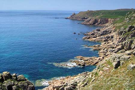
Walk from Porthgwarra which lies west of Porthcurno exploring the coast and countryside. The route follows a section of the South West Coast Path between St Levan and Higher Bosistow with rugged cliffs and fine coastal scenery. The inland section of the walk uses paths and tracks across the rolling countryside in this beautiful part of Cornwall.
The walk starts from the pay and display car park at Porthgwarra (grid ref. SW371218) which is reached by a lane from the B3315 at Polgigga. After parking walk towards the sea and just before the road bends sharp left join the South West Coast Path signed on the right. After a short climb, the path undulates along the cliff tops to round Gwennap Head with the National Coastwatch observation post a prominent feature. Stay on the coast for a further two kilometres to reach the promontory of Carn Les Boel which was the site of an Iron Age Fort (grid ref. SW357232).
After exploring the remains of the fort return to the coast path and go straight across. And head in an easterly direction to a gate (grid ref. SW363232). Continue along the enclosed path soon passing a house on the right. Continue ahead to the group of buildings at Higher Bosistow. Just before the buildings turn right onto a clear track. This track is followed for just under a kilometre to a lane. Turn right along the lane and continue past Arden-Sawah Farm on your right. Continue to where the lane bends right. ignore the overgrown footpath on the left and continue for another 100 metres to the next footpath on the left (grid ref. SW373228). The well-used path heads in a southeasterly direction across fields crossing stiles along the way. To help with navigation aim for the church tower at St Levan.
Reaching a lane with the church opposite, turn right and after 100 metres fork right off the lane at a fingerpost along a track (signed to the coast path), Reaching a house on the left continue ahead to join a path. The path crosses a stream and shortly after reaches a junction (grid ref. SW379221). Keep right here and continue along the right-hand side of a field to re-join the South West Coast Path. The path soon starts to descend and leads to the sea at Porthgwarra and the end of the walk.
Other walks nearby
| Walk 1226 | Land's End & Sennen Cove from Porthcurno | moderate | 6.5 miles |
| Walk 2614 | St Loy's Cove & Logan Rock | moderate | 8.5 miles |
| Walk 2354 | Merry Maidens & Lamorna Cove | easy | 4.1 miles |
| Walk 1225 | Sennen Cove & Botallack from St Just | moderate | 7.5 miles |
| Walk 2616 | The moors and hills of Penwith | moderate | 14.0 miles |
| Walk 1028 | Chun Quoit and Botallack | moderate | 8.0 miles |
| Walk 2205 | Newlyn - a village trail | easy | 1.0 miles |
| Walk 3325 | Chun Quoit & Carn Kenidjack | easy | 4.0 miles |
| Walk 1224 | Men-an-tol & Ding Dong Mine | easy | 3.0 miles |
| Walk 2207 | Penzance - a town stroll | easy | 1.5 miles |
Recommended Books & eBooks
The South West Coast Path
 Guidebook to walking the entire South West Coast Path National Trail. The route runs for 630 miles from Minehead to Poole along the north Devon, Cornish, south Devon and Dorset coastline. Divided into 45 stages, this long-distance coastal trek could be completed within 4 weeks, or walked in sections. Guide includes maps and essential information.
More information
South West Coast Path Map Booklet - St Ives to Plymouth
 Map of part of the southern section of the 630 mile (1014km) South West Coast Path National Trail. Covers the trail from St Ives to Plymouth along the west Cornwall and Devon coastline. This convenient and compact booklet of Ordnance Survey 1:25,000 maps shows the route, providing all of the mapping you need to walk the trail in either direction.
More information
Messaging & Social Media
Message Walking Britain and follow the latest news.

Mountain Weather
Stay safe on the mountains with detailed weather forecasts - for iOS devices or for Android devices.