Chirk Castle & Ceiriog Valley
Wrexham Walk
County/Area - Wrexham & Shropshire
Author - Lou Johnson
Length - 6.0 miles / 9.8 km Ascent - 1000 feet / 303 metres
Time - 4 hours 0 minutes Grade - easy/mod
Maps 

| Ordnance Survey Explorer 240 | Sheet Map | 1:25k | BUY |
| Anquet OS Explorer 240 | Digital Map | 1:25k | BUY |
Walk Route Description
Click image to see photo description.
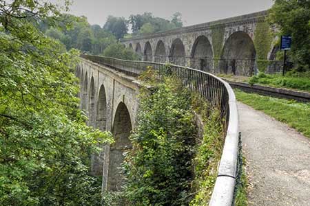
Starting from Chirk, this circular walk has plenty of interest, The route passes Chirk Castle, explores the Ceiriog Valley surrounded by rounded hills, and crosses the Chirk Aqueduct which was designed by civil engineer Thomas Telford and opened in 1801. The walk also crosses the Wales-England border.
The walk starts from Chirk Railways station (grid ref. SJ285378) with parking available at the station. Exit the station and walk up to Station Avenue and turn right. Cross the railway and turn right through a gate with an adjacent footpath sign. Once through the gate turn left along a path through trees. Continue for 150m metres and turn left through a gate and cross a field to a road. Turn right, and then left up a track to enter the extensive grounds of Chirk Castle. Go through the gate and follow a waymarked path (arrows) uphill. Nearing the top, the path heads half-left and continues to join a driveway. Walk ahead with Chirk Castle on your left. Continue ahead bearing left towards the car park. Take the path on the left-hand side of the parking area. Continue uphill through gates to reach a lane with a cottage on your left (grid ref. SJ263390).
Turn left along the lane and almost immediately turn left through a metal kissing gate to join the Offa's Dyke Path. Head uphill and then steeply down. Reaching the bottom follow the ODP sign and continue down the hillside with Gwyningar Wood on your left. Reaching a road, go straight across soon crossing the River Ceiriog into Shropshire. You are now following the Maelor Way. Follow the lane steeply uphill to a T-junction. Turn left and continue uphill. After 600 metres you reach a side road on the left with a sign pointing to Hafod and an adjacent fingerpost. Turn left down this lane to pass a row of house on the left. Take the track ahead which descends to join a path through woodland and beside the River Ceiriog. Continue to reach a stile and a lane (grid ref. SJ279370).
Continue ahead along the lane. Do not cross the river and bear right and then fork left along a narrow lane. Continue to pass a modern farm building on your left and then fork left onto a path into woodland just before a right-hand bend. The path leads across a field before crossing the railway line. Do take care on this crossing. Once across the railway the path passes through two gates and then runs between houses to a road (grid ref. SJ 292370). Turn left, cross the canal bridge, and then walk left to join the towpath. Cross the Chirk Aqueduct which runs parallel with a railway viaduct. Reaching the entrance to the canal tunnel you have a choice. Either walk through the 400-metre-long tunnel where a torch is useful or walk up the higher right-hand path up to a road. Go straight across the roundabout to return to Chirk station which is signed.
Other walks nearby
| Walk 2460 | Pontcysyllte Aqueduct Circular | easy | 4.5 miles |
| Walk 2598 | Ruabon Mountain, World's End & Panorama Circular | moderate | 12.5 miles |
| Walk 1067 | Ruabon Mountain & The Limestone Edges of Llangollen | moderate | 11.0 miles |
| Walk 1845 | Castell Dinas Bran from Llangollen | easy/mod | 4.0 miles |
| Walk 3655 | Rhewl, Moel y Gamelin & Moel Morfydd | moderate | 5.4 miles |
| Walk 2905 | The Llangollen Canal from Ellesmere | easy/mod | 8.0 miles |
| Walk 1989 | Llanarmon Dyffryn Ceiriog Circular | moderate | 6.0 miles |
| Walk 3031 | Cadair Berwyn | moderate | 9.3 miles |
| Walk 3535 | River Dee from Farndon | easy | 4.0 miles |
| Walk 1086 | Post Gwyn and Craig-y-Mwn from Pistyll Rhaeadr | moderate | 6.5 miles |
Recommended Books & eBooks
No suggestions for this area.Messaging & Social Media
Message Walking Britain and follow the latest news.

Mountain Weather
Stay safe on the mountains with detailed weather forecasts - for iOS devices or for Android devices.