Walk 2393 - printer friendly version
Weardale Circular from Westgate Walk
Author - Lou Johnson
Length - 6.4 miles / 10.4 km
Ascent - 900 feet / 273 metres
Grade - easy/mod
Start - OS grid reference NY908381
Lat 54.7377860 + Long -2.1444075
Postcode DL13 1SD (approx. location only)
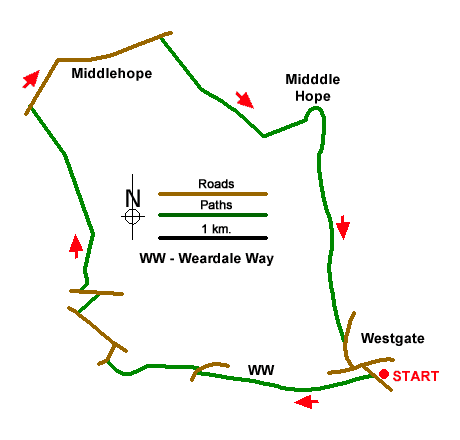
A circular walk from Westgate full of interest. The route follows the Weardale Way upstream before exploring the Weardale moors. The route includes field paths, walled lanes, the remains of Slitt Mine and the partially wooded valley containing Middlehope Burn.
On-street parking is available near the Hare and Hounds in Westgate (grid ref. NY908381). After parking take the lane beside the pub signed to Brotherlee. Cross the River Wear and take the signed footpath on the right. Cross the stile and follow the Weardale Way across fields to reach kissing gate and a lane. Cross the lane to the signed path opposite. The path leads across fields latterly running close to the river. Climb the steps up to the A689 at Bridge End. Cross the road to continue along the Weardale Way running beside the river. Reaching the next lane, turn right over the footbridge and continue to a T-junction (grid ref. NY889382).
Turn left and continue uphill for 400 metres to turn right at footpath fingerpost up a clear track. When the track bends right continue ahead up across fields to reach a road (Side Head). Turn left, enjoy the view over Weardale on your left, and continue up to the next fingerpost on the right. To join a rising track between walls. After 700 metres the wall on the left ends. Continue ahead across open moor with the path running close to a wall on your right. Follow this path to reach a road (grid ref. NY883401).
Turn right uphill soon passing a plantation on your left and the highest point of the walk. Follow the road as it bends left and descend Middlehope Bank. After 800 metres of easy downhill walking, you reach a fingerpost on the right. Turn right and follow the track for a kilometre to a junction (grid ref. NY901399). Turn left and continue along the track to cross Middlehope Burn. Continue along the track until it turns sharp left. Leave the track here and turn right. The path runs beside a wall on your left. The onward path follows Middlehope Burn downstream and after a kilometre reaches the remains of Slitt Mine. Continue south on the path beside the burn, crossing and recrossing the stream. Before joining a track, which leads to a road. Bear right downhill and continue to the A689 in Westgate. Turn left back to the start.
Messaging & Social Media
Message Walking Britain and follow the latest news.

Mountain Weather
Stay safe on the mountains with detailed weather forecasts - for iOS devices or for Android devices.