Warren Point & Bolt Tail from Bantham
Coastal Walk
County/Area - Devon - SWCP South Devon
Author - Lou Johnson
Length - 9.0 miles / 14.6 km Ascent - 1000 feet / 303 metres
Time - 5 hours 30 minutes Grade - moderate
Maps 

| Ordnance Survey Explorer OL20 | Sheet Map | 1:25k | BUY |
| Anquet OS Explorer OL20 | Digital Map | 1:25k | BUY |
Walk Route Description
Click image to see photo description.
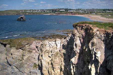
Starting from Bantham at the mouth of the River Avon this walk explores the coast south to Bolt Tail headland using the South West Coast Path. The route includes cliffs, sandy coves and beaches, a section with a rocky foreshore, and the villages of Outer Hope and Thurlestone.
The walk starts from Bantham Beach car park (grid ref. SX665437). After parking return to the car park entrance and continue along the road to the first passing place and turn left onto a grassy path to reach the River Avon. Turn left along the shore and continue past Hams Cottage to the end of the sandy headland with across the river to Bigbury-on-Sea. Follow the path around the headland and continue south with the sea on your right. Where the path turns sharp left, continue ahead across the back of the Bantham Beach. Continue to the end of the beach and bear left just before the Surf and Life Saving Club to join the South West Coast Path (grid ref. SX662436).
Turn right and follow the coast path for two kilometres passing Yarmer Beach to reach Warren Point. Continue south along the coast path soon passing Leas Foot Sand and Thurlestone car park on your left. The path then runs along the back off Thurlestone Beach and South Milton Sand to reach a road (grid ref. SX677416). Continue ahead along the road and where it bends sharp left, turn right by a fingerpost. Continue along the path to pass Outer Hope soon reaching the pleasant beach at Hope Cove with its protective breakwater.
The coast path joins a road which is followed until it bends left. From here take the steps and climb onto the clifftop. Reaching an open grassy area, continue ahead to reach a marker post where the SWCP turns left. Leave the SWCP and walk out onto the headland of Bolt Tail. The view north is excellent and includes much of the walk. From the headland continue along the cliffs with the sea on your right to re-join the Coast Path. After 500 metres, turn left onto a grassy path which follows the field boundary on your immediate right. The path descends to trees before joining a lane which passes a group of thatched cottages to reach a T-junction. Turn left to rejoin the outward route (grid ref. SX675397).
Follow the road round to the right and follow the South West Coast Path north. Reaching Leas Foot Sand, fork left off the coast path following a track which soon becomes tarmac and leads to a T-junction. Turn left and continue ahead to pass a war memorial on your left with the parish church ahead. Turn left in front of the church, and then first right onto a track with the churchyard on your right. The track enters a field and continues into another field. Where the tracks bends right, continue ahead to follow the footpath across more fields to descend to a road in Bantham. Turn left and return to Bantham Beach car park.
Other walks nearby
| Walk 3041 | Thurlestone circular | easy | 4.0 miles |
| Walk 3657 | Bigbury-on-Sea, Arymer Cove & Burgh Island | easy/mod | 5.0 miles |
| Walk 1975 | Erme Mouth | moderate | 9.0 miles |
| Walk 3432 | Salcombe to Thurlestone | mod/hard | 11.0 miles |
| Walk 3276 | Gara Point & Stoke Point from Noss Mayo | easy/mod | 7.0 miles |
| Walk 2012 | Wembury Bay & St Peter's Church from Noss Mayo | easy/mod | 6.0 miles |
| Walk 1866 | East Prawle & Prawle Point | easy/mod | 4.1 miles |
| Walk 2474 | East Prawle Coast Circular | easy/mod | 5.6 miles |
| Walk 3431 | Beeson to Salcombe | mod/hard | 12.0 miles |
| Walk 3427 | Slapton Sands & Stokenham from Torcross | easy/mod | 8.0 miles |
Recommended Books & eBooks
The South West Coast Path
 Guidebook to walking the entire South West Coast Path National Trail. The route runs for 630 miles from Minehead to Poole along the north Devon, Cornish, south Devon and Dorset coastline. Divided into 45 stages, this long-distance coastal trek could be completed within 4 weeks, or walked in sections. Guide includes maps and essential information.
More information
South West Coast Path Map Booklet - Minehead to St Ives
 Map of the northern section of the 630 mile (1014km) South West Coast Path National Trail. Covers the trail from Minehead to St Ives along the north Devon and Cornish coastline. This convenient and compact booklet of Ordnance Survey 1:25,000 maps shows the route, providing all of the mapping you need to walk the trail in either direction.
More information
Messaging & Social Media
Message Walking Britain and follow the latest news.

Mountain Weather
Stay safe on the mountains with detailed weather forecasts - for iOS devices or for Android devices.