East Prawle Coast Circular
Coastal Walk + Pub Walk
County/Area - Devon - SWCP South Devon
Author - Lou Johnson
Length - 5.6 miles / 9.1 km Ascent - 800 feet / 242 metres
Time - 3 hours 40 minutes Grade - easy/mod
Maps 

| Ordnance Survey Explorer OL20 | Sheet Map | 1:25k | BUY |
| Anquet OS Explorer OL20 | Digital Map | 1:25k | BUY |
Walk Route Description
Click image to see photo description.
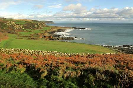
An excellent walk from East Prawle exploring the coast between Elender Cove and Woodcombe Point, the most southerly section of coast in Devon. The route uses quiet country lanes, tracks, and a section of the South West Coast Path which follows the low cliff tops past Prawle Point and Langerstone Point. At the end of the walk refreshments are available at the Pig's Nose Inn.
The walk starts from the village green in East Prawle where parking is available opposite the telephone box (grid ref. SX781364). After parking and facing the telephone box, turn left and follow the lane out of the village. After 350 metres the lane bends left. Continue ahead to join an enclosed track with a bridleway fingerpost on the left. Stay on the track for 1.3 kilometres to reach a T-junction (grid ref. SX767361). Turn left and descend steeply towards the sea. The path stays close to a wall on your right. When the wall ends descend through a rocky landscape and turn right at the first junction. The path soon joins the South West Coast Path (SWCP) above Elender Cove.
Turn left to follow the SWCP. The path runs along the tops of low cliffs, and you soon arrive at National Coastwatch lookout station on Prawle Point where there is a visitor centre offering information about this stretch of coast and its wildlife. The onward route continues along the SWCP soon passing a row of former coastguard cottages. It then continues across a raised beach with a line of landlocked cliffs on your left. The path crosses Langerstone Point. Approaching Woodcombe Sands, the SWCP turns inland and reaches a fingerpost signed East Prawle (grid ref. SX795369). Turn left off the SWCP and continue up an enclosed path.
Keep ahead and nearing the top of the climb you reach a T-junction. Turn left onto a bridleway which soon leads into an access driveway. Continue ahead and follow the clear track as it bends right. When the driveway bends right, turn left, and continue along the bridleway along the right-hand edge of a field. The track briefly passes through trees. 200 metres beyond the trees, turn right and follow the enclosed bridleway to a lane at the edge of East Prawle. Turn left and continue to a phone box. Ignore the road on the right and the left fork and keep ahead through the village to a T-junction. Turn left and soon after right to return to the village green.
Other walks nearby
| Walk 1857 | Start Point & East Prawle | moderate | 8.2 miles |
| Walk 3432 | Salcombe to Thurlestone | mod/hard | 11.0 miles |
| Walk 3431 | Beeson to Salcombe | mod/hard | 12.0 miles |
| Walk 3427 | Slapton Sands & Stokenham from Torcross | easy/mod | 8.0 miles |
| Walk 3346 | Start Point from Torcross | easy/mod | 8.0 miles |
| Walk 2461 | Warren Point & Bolt Tail from Bantham | moderate | 9.0 miles |
| Walk 3041 | Thurlestone circular | easy | 4.0 miles |
| Walk 3657 | Bigbury-on-Sea, Arymer Cove & Burgh Island | easy/mod | 5.0 miles |
| Walk 1975 | Erme Mouth | moderate | 9.0 miles |
| Walk 2371 | Kingswear to Brixham | moderate | 10.8 miles |
Recommended Books & eBooks
South West Coast Path Map Booklet - Minehead to St Ives
 Map of the northern section of the 630 mile (1014km) South West Coast Path National Trail. Covers the trail from Minehead to St Ives along the north Devon and Cornish coastline. This convenient and compact booklet of Ordnance Survey 1:25,000 maps shows the route, providing all of the mapping you need to walk the trail in either direction.
More information
The South West Coast Path
 Guidebook to walking the entire South West Coast Path National Trail. The route runs for 630 miles from Minehead to Poole along the north Devon, Cornish, south Devon and Dorset coastline. Divided into 45 stages, this long-distance coastal trek could be completed within 4 weeks, or walked in sections. Guide includes maps and essential information.
More information
Messaging & Social Media
Message Walking Britain and follow the latest news.

Mountain Weather
Stay safe on the mountains with detailed weather forecasts - for iOS devices or for Android devices.