Walk 2462 - printer friendly version
The Rumps & Pentire Point Walk
Author - Lou Johnson
Length - 4.0 miles / 6.5 km
Ascent - 600 feet / 182 metres
Grade - easy/mod
Start - OS grid reference SW941800
Lat 50.5833450 + Long -4.9098653
Postcode PL27 6QY (approx. location only)
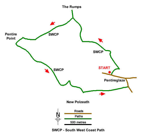
This energetic walk explores the Rumps and Pentire Point in North Cornwall. The coastline is rocky with cliffs rising two hundred feet above the sea. Also of interest are the remains of the Iron Age Rumps castle. The start is the Lead Mines National Trust car park near Pentireglaze (grid ref. SW941800).
After exploring The Rumps, return to the gap in the wall and turn right to continue, with the sea on your right, along the South West Coast Path. The path leads to Pentire Point. Offshore is rocky Newland, another small island. There is also a fine view along the north Cornwall Coast.
The onward path descends across the cliff, almost down to sea level. The path continues along the rocky foreshore with a view ahead to Polzeath. The path soon turns inland up a rocky valley before turning sharp right up the side of the valley. After a short ascent, the path descends zigzags down the hillside to reach Pentireglaze Haven Beach. Continue across the back of the beach and turn left up a track (grid ref. SW936796) with a house on your left. Follow the rising track for 800 metres to a road. Turn left, pass to the left of the National Trust's buildings at Pentireglaze, and continue uphill following the road as it swings left by cottages. Cross the cattle grid and the Lead Mines car park is 300 metres on the right.
Messaging & Social Media
Message Walking Britain and follow the latest news.

Mountain Weather
Stay safe on the mountains with detailed weather forecasts - for iOS devices or for Android devices.