The Rumps & Pentire Point
Coastal Walk + Hill Fort
Region - Cornwall AONB
County/Area - Cornwall
Author - Lou Johnson
Length - 4.0 miles / 6.5 km Ascent - 600 feet / 182 metres
Time - 2 hours 40 minutes Grade - easy/mod
Maps 

| Ordnance Survey Explorer 106 | Sheet Map | 1:25k | BUY |
| Anquet OS Explorer 106 | Digital Map | 1:25k | BUY |
Walk Route Description
Click image to see photo description.
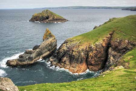
This energetic walk explores the Rumps and Pentire Point in North Cornwall. The coastline is rocky with cliffs rising two hundred feet above the sea. Also of interest are the remains of the Iron Age Rumps castle. The start is the Lead Mines National Trust car park near Pentireglaze (grid ref. SW941800).
After exploring The Rumps, return to the gap in the wall and turn right to continue, with the sea on your right, along the South West Coast Path. The path leads to Pentire Point. Offshore is rocky Newland, another small island. There is also a fine view along the north Cornwall Coast.
The onward path descends across the cliff, almost down to sea level. The path continues along the rocky foreshore with a view ahead to Polzeath. The path soon turns inland up a rocky valley before turning sharp right up the side of the valley. After a short ascent, the path descends zigzags down the hillside to reach Pentireglaze Haven Beach. Continue across the back of the beach and turn left up a track (grid ref. SW936796) with a house on your left. Follow the rising track for 800 metres to a road. Turn left, pass to the left of the National Trust's buildings at Pentireglaze, and continue uphill following the road as it swings left by cottages. Cross the cattle grid and the Lead Mines car park is 300 metres on the right.
Other walks nearby
| Walk 3264 | Port Quin & Port Isaac Circular | easy/mod | 5.7 miles |
| Walk 3738 | Polzeath & Pentire Point from Rock | moderate | 11.4 miles |
| Walk 3589 | Padstow from Little Petherick | easy | 5.0 miles |
| Walk 1547 | Trevose Head & Constantine Bay from Porthcothan | easy/mod | 8.5 miles |
| Walk 1961 | Porthcothan to Watergate Bay | easy/mod | 6.8 miles |
| Walk 1029 | Tintagel to Boscastle | moderate | 9.0 miles |
| Walk 1883 | Advent Church | easy | 5.2 miles |
| Walk 1808 | Brown Willy, exploring Cornwall's highest Tors | easy/mod | 4.0 miles |
| Walk 3279 | Tors of Bodmin Moor | moderate | 10.0 miles |
| Walk 1104 | Newquay to Porthcothan coast path | moderate | 10.5 miles |
Recommended Books & eBooks
South West Coast Path Map Booklet - Minehead to St Ives
 Map of the northern section of the 630 mile (1014km) South West Coast Path National Trail. Covers the trail from Minehead to St Ives along the north Devon and Cornish coastline. This convenient and compact booklet of Ordnance Survey 1:25,000 maps shows the route, providing all of the mapping you need to walk the trail in either direction.
More information
Walking in Cornwall
 This guidebook includes routes to 40 day walks in Cornwall. From short, easy strolls to longer, wilder routes, there is plenty to appeal to both families and experienced walkers. The walks explore the interior and coasts, including walks through picturesque villages, old tin-mining areas and the Lizard and Land's End Peninsulas.
More information
Messaging & Social Media
Message Walking Britain and follow the latest news.

Mountain Weather
Stay safe on the mountains with detailed weather forecasts - for iOS devices or for Android devices.