Arnside Knott Circular
Hill Walk + Pub Walk + Coastal Walk
County/Area - Cumbria - South Cumbria
Author - Lou Johnson
Length - 6.0 miles / 9.8 km Ascent - 800 feet / 242 metres
Time - 3 hours 50 minutes Grade - easy/mod
Maps 

| Ordnance Survey Explorer OL7 | Sheet Map | 1:25k | BUY |
| Anquet OS Explorer OL7 | Digital Map | 1:25k | BUY |
Walk Route Description
Click image to see photo description.
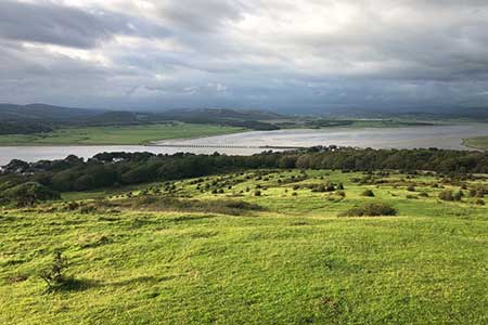
An excellent walk from Arnside (Cumbria) exploring the shores of the Kent Estuary and Arnside Knott. The paths are good and the views superb which include Morecambe Bay. The route follows the shores of the Kent Estuary to Far Arnside where the walk turns inland to reach the summit of Arnside Knott.
The start is on-street parking near Arnside Station (grid ref. SD461788). After parking walk along Station Road with the railway on your right. You soon arrive beside the shores of the Kent Estuary. Continue along the Promenade as far as The Albion Inn. Fork right and continue beside the estuary. Note alternative parking is available on the next section of road. Walk to the end of the road and join the footpath signed to New Barns Bay where the path turns inland to reach a junction of tracks (grid ref. SD444777).
Turn right and shortly after left in front a café. Enter New Barns Caravan Site following a path signed to Far Arnside. Continue through the site bearing left past a barrier and follow track ahead. Reaching a fork, turn right again signed Far Arnside via Beach. The track continues to the sea. Turn left along the waterfront beside the beach to rocky Arnside Point. The path continues up a slope and continues above the sea through trees. The path soon becomes wider and continues to rise to reach a track with a sign for Far Arndale. Head through the gate and soon join an access drive to a caravan site.
Walk ahead and take the upper driveway with footpath sign. Walk ahead through the site and continue to a lane. Exit the site to a footpath on the left signed to Arnside and The Knott (grid ref. SD450764). At the next junction turn left for Arnside. Pass through a gat and bear right on a rising path across the flank of Heathwaite to a path junction. Walk ahead for Arnside Knott. Reaching the next junction by a bench, turn right on a rising wide path. After 150 metres, turn left up a path to reach the viewpoint (grid ref. SD452774).
Retrace your steps back to the junction and bear left up a broad rising path. Nearing the summit of Arnside Knott, bear right up a path which leads to the OS trig column. After enjoying the view drop down to the main path Descend north with path getting closer to woodland on your right. And a clump of trees to your left. Turn left on a grassy path running to the left of the clump of trees. Continue ahead to reach a lane. Turn right downhill. Continue ahead to reach a fingerpost on the left signed to the promenade. Follow this path down to seafront and turn right back to the start.
Other walks nearby
| Walk 2511 | Silverdale & Arnside | easy/mod | 8.0 miles |
| Walk 2543 | Silverdale, Hawes Water & Jenny Brown's Point | easy | 7.0 miles |
| Walk 3549 | Whitbarrow Scar from Mill Side | moderate | 6.5 miles |
| Walk 3199 | Whitbarrow Fell from Mill Side | moderate | 7.0 miles |
| Walk 1045 | Levens Bridge to Kendal | easy/mod | 11.5 miles |
| Walk 3450 | Humphrey Head from Allithwaite | easy | 4.0 miles |
| Walk 1148 | Scout Scar from Sizergh | moderate | 11.0 miles |
| Walk 2721 | Scout Scar Limestone Ridge | easy/mod | 5.0 miles |
| Walk 2143 | Whitbarrow & Lord's Seat | easy/mod | 5.4 miles |
| Walk 3234 | Gummers How via Chapel House Wood, South Lake District | easy/mod | 5.5 miles |
Recommended Books & eBooks
Hadrian's Wall Path
 Hadrians Wall Path guidebook to walk the 84 mile National Trail. Described in both directions, the main description is west to east between Bowness-on-Solway and Wallsend, Newcastle, with extensions to Maryport and South Shields. With extensive historical information related to this World Heritage site and separate 1:25,000 OS map booklet included.
More information
Walking the Lake District Fells - Buttermere
 Part of the Walking the Lake District Fells series, this guidebook covers a wide range of routes to 32 Lakeland summits that can be climbed from the Buttermere, Lorton and Newlands valleys, with highlights including Haystacks, High Stile, Grasmoor and the fells of the Coledale Round. Suggestions for longer ridge routes are also included.
More information
Messaging & Social Media
Message Walking Britain and follow the latest news.

Mountain Weather
Stay safe on the mountains with detailed weather forecasts - for iOS devices or for Android devices.