Walk 3587 - printer friendly version
Kingswear from Coleton Fishacre Walk
Author - Lou Johnson
Length - 7.0 miles / 11.4 km
Ascent - 1200 feet / 364 metres
Grade - moderate
Start - OS grid reference SX910512
Lat 50.3505940 + Long -3.5334329
Postcode TQ6 0EQ (approx. location only)
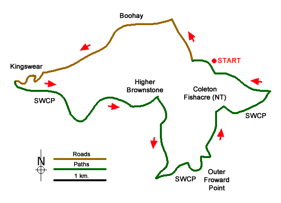
This Devon walk visits the bustling harbour of Kingswear with views across the estuary to Dartmouth. The route then continues east along the South West Coast Path to enjoy some wonderful coastal panoramas along the way. The walk then turns inland to Higher Brownstone from where more glorious views can be enjoyed. To complete the walk a descent back to the coast path to picturesque Ivy Cove from where it is a short walk back to the start.
The start is the National Trust car park for Coleton Fishacre (grid ref. SX910512), which is free to National Trust members. Exit the car park and follow the lane used for entry to the car park. After 250 metres you reach a crossroads. Turn right and continue past Kingston Springs Farm (on your left) to the next road junction. Turn left at the next junction. Where the main lane bears right, continue straight ahead down the narrower lane. Follow this lane to the next road junction (grid ref. SX897518). Again, bear left onto Mount Ridley Road.
After 1.6 kilometres of walking, with some views of the Dart estuary on your right, the road swings round to the right and reaches a junction (grid ref. SX884510). Turn left down Ridley Hill. Follow the road around to the right to join Church Hill. When you reach the churchyard on your right turn sharp left onto Beacon Road. However, you may continue past the church to explore the harbour area before returning to this point.
Continue along Beacon Road (which is also the South West Coast Path) and continue to the end of the road. Continue along the path to Castle Road (grid ref. SX886509). Bear right and follow the road for 800 metres. Just after the road bends to the left after passing Kingswear Castle below on the right, note the signed footpath on the right (SWCP), which descends into Mill Bay Cove and onto the Lookout Station (grid ref. SX903497). You can take this route if you prefer and follow the waymarked SWCP.
However, this walk continues inland still following Castle Road. Keep right at the first fork and continue to Home Farm, bearing right just before you reach the farm on an enclosed track that leads to Higher Brownstone Farm. The path passes through the farm keeping the farm buildings on your right and the farmhouse on your left. Continue ahead passing a large barn on the right and then at a junction of tracks by some trees turn right to follow track between fields.
Continue straight head to join a well-made track that descends to reach the Lookout Station (grid ref. SX903497). From the end of the track, the SWCP initially heads west and then loops around to the left before following a sinuous route pass Old Mill Bay to reach Pudcombe Cove, which lies below the grounds of Coleton Fishacre. Stay on the SWCP as shown on the OS map trending away from sea to reach the head of Ivy Cove (grid ref. SX918508). Turn left here following a concessionary footpath aiming for a small group of trees. From here the path crosses two fields (with the hedge on your left) to reach the car park used at the start of the walk.
Messaging & Social Media
Message Walking Britain and follow the latest news.

Mountain Weather
Stay safe on the mountains with detailed weather forecasts - for iOS devices or for Android devices.