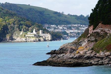
Kingswear from Coleton Fishacre
Devon Walk
County/Area - Devon
Author - Lou Johnson
Length - 7.0 miles / 11.4 km Ascent - 1200 feet / 364 metres
Time - 4 hours 40 minutes Grade - moderate
Maps 

| Ordnance Survey Explorer OL20 | Sheet Map | 1:25k | BUY |
| Anquet OS Explorer OL20 | Digital Map | 1:25k | BUY |
| Ordnance Survey Landranger 202 | Sheet Map | 1:50k | BUY |
| Anquet OS Landranger 202 | Digital Map | 1:50k | BUY |
Walk Route Description
Click image to see photo description.
This Devon walk visits the bustling harbour of Kingswear with views across the estuary to Dartmouth. The route then continues east along the South West Coast Path to enjoy some wonderful coastal panoramas along the way. The walk then turns inland to Higher Brownstone from where more glorious views can be enjoyed. To complete the walk a descent back to the coast path to picturesque Ivy Cove from where it is a short walk back to the start.
The start is the National Trust car park for Coleton Fishacre (grid ref. SX910512), which is free to National Trust members. Exit the car park and follow the lane used for entry to the car park. After 250 metres you reach a crossroads. Turn right and continue past Kingston Springs Farm (on your left) to the next road junction. Turn left at the next junction. Where the main lane bears right, continue straight ahead down the narrower lane. Follow this lane to the next road junction (grid ref. SX897518). Again, bear left onto Mount Ridley Road.
After 1.6 kilometres of walking, with some views of the Dart estuary on your right, the road swings round to the right and reaches a junction (grid ref. SX884510). Turn left down Ridley Hill. Follow the road around to the right to join Church Hill. When you reach the churchyard on your right turn sharp left onto Beacon Road. However, you may continue past the church to explore the harbour area before returning to this point.
Continue along Beacon Road (which is also the South West Coast Path) and continue to the end of the road. Continue along the path to Castle Road (grid ref. SX886509). Bear right and follow the road for 800 metres. Just after the road bends to the left after passing Kingswear Castle below on the right, note the signed footpath on the right (SWCP), which descends into Mill Bay Cove and onto the Lookout Station (grid ref. SX903497). You can take this route if you prefer and follow the waymarked SWCP.
However, this walk continues inland still following Castle Road. Keep right at the first fork and continue to Home Farm, bearing right just before you reach the farm on an enclosed track that leads to Higher Brownstone Farm. The path passes through the farm keeping the farm buildings on your right and the farmhouse on your left. Continue ahead passing a large barn on the right and then at a junction of tracks by some trees turn right to follow track between fields.
Continue straight head to join a well-made track that descends to reach the Lookout Station (grid ref. SX903497). From the end of the track, the SWCP initially heads west and then loops around to the left before following a sinuous route pass Old Mill Bay to reach Pudcombe Cove, which lies below the grounds of Coleton Fishacre. Stay on the SWCP as shown on the OS map trending away from sea to reach the head of Ivy Cove (grid ref. SX918508). Turn left here following a concessionary footpath aiming for a small group of trees. From here the path crosses two fields (with the hedge on your left) to reach the car park used at the start of the walk.
Other walks nearby
| Walk 2371 | Kingswear to Brixham | moderate | 10.8 miles |
| Walk 1323 | Broadsands Beach and Brixham | easy | 4.0 miles |
| Walk 3427 | Slapton Sands & Stokenham from Torcross | easy/mod | 8.0 miles |
| Walk 3346 | Start Point from Torcross | easy/mod | 8.0 miles |
| Walk 3431 | Beeson to Salcombe | mod/hard | 12.0 miles |
| Walk 2912 | Dartington from Totnes | easy | 2.5 miles |
| Walk 1857 | Start Point & East Prawle | moderate | 8.2 miles |
| Walk 1866 | East Prawle & Prawle Point | easy/mod | 4.1 miles |
| Walk 2474 | East Prawle Coast Circular | easy/mod | 5.6 miles |
| Walk 3432 | Salcombe to Thurlestone | mod/hard | 11.0 miles |
Recommended Books & eBooks
South West Coast Path Map Booklet - Minehead to St Ives
 Map of the northern section of the 630 mile (1014km) South West Coast Path National Trail. Covers the trail from Minehead to St Ives along the north Devon and Cornish coastline. This convenient and compact booklet of Ordnance Survey 1:25,000 maps shows the route, providing all of the mapping you need to walk the trail in either direction.
More information
South West Coast Path Map Booklet - St Ives to Plymouth
 Map of part of the southern section of the 630 mile (1014km) South West Coast Path National Trail. Covers the trail from St Ives to Plymouth along the west Cornwall and Devon coastline. This convenient and compact booklet of Ordnance Survey 1:25,000 maps shows the route, providing all of the mapping you need to walk the trail in either direction.
More information
Messaging & Social Media
Message Walking Britain and follow the latest news.

Mountain Weather
Stay safe on the mountains with detailed weather forecasts - for iOS devices or for Android devices.