Waun Fach from Castell Dinas, near Talgarth
Brecon Beacons/Bannau Brycheiniog Walk
Nat Park - Brecon Beacons - Brecon Beacons East
County/Area - Powys
Author - Lou Johnson
Length - 7.5 miles / 12.2 km Ascent - 2080 feet / 630 metres
Time - 5 hours 50 minutes Grade - mod/hard
Maps 

| Ordnance Survey Explorer OL13 | Sheet Map | 1:25k | BUY |
| Anquet OS Explorer OL13 | Digital Map | 1:25k | BUY |
| Ordnance Survey Landranger 161 | Sheet Map | 1:50k | BUY |
| Anquet OS Landranger 161 | Digital Map | 1:50k | BUY |
Walk Route Description
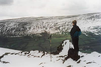
Click image to visit gallery of 2 images.
The Brecon Beacons National Park naturally focuses on the high land of the Beacons themselves. However there is much else to keep walkers busy with the Black Mountains offering high level walks of quality without the crowds often encountered on Pen-y-Fan.
This walk starts near Castell Dinas located a few miles south of Talgarth on the A479 to Crickhowell. Parking is available in the lane (grid ref. SO177303). From here continue to the end of the lane and take the bridleway that climbs over the col between Castell Dinas and the ridge coming down from Y Grib, which will be used for the return. Stay with the bridleway as it descends to Rhyd-y-car farm. Turn left here and continue on the right of way heading east. The path crosses a number of fields climbing at the while to reach the boundary of open country (grid ref. SO194302).
You have the option of either heading straight up the hillside or taking an easier left-right zig-zag to join the clear rising path that heads roughly south across the flanks of Waun Fach to reach a large cairn near a 618 metre spot height marked on the OS 1:25,000 map. Near this cairn turn north on a distinct path to follow a broad ridge, which leads directly to the summit of Waun Fach.
The highest point in the eastern sector of the Brecon Beacons National Park (known as the Black Mountains) the summit area offers good views in all directions. However foreground interest is limited due to the "dome like" nature of the mountain. Away to the west are the highest peaks of the Beacons whilst to the east are the high parallel ridges that complete the Black Mountains with Hay Bluff the best known summit. From the summit of Waun Fach a clear path descends just west of north roughly following the highest ground. Stay with this path for about a mile to reach a junction where you turn left to descend over Y Grib to reach your transport. The descent is very pleasant offering good views especially to the Usk Valley and the high ground of Mid-Wales beyond.
The photos included with this walk description were taken during worsening winter conditions with a snow storm approaching. Inexperienced walkers should not attempt to complete any high level routes in these conditions and it is recommended that a speedy return to lower levels is made.
Other walks nearby
| Walk 3204 | Hay Bluff & Twmpa | moderate | 10.3 miles |
| Walk 2935 | Llanthony Priory from Capel-y-ffin | easy/mod | 7.7 miles |
| Walk 1238 | Hay Bluff & Twmpa Circular | moderate | 6.0 miles |
| Walk 3546 | Pen y Bryn from Pencelli | moderate | 5.0 miles |
| Walk 3536 | Pen y Bryn & Carn Pica from Pencelli | mod/hard | 11.3 miles |
| Walk 3209 | Llanfrynach and Pencelli circular | easy/mod | 5.6 miles |
| Walk 1237 | Cwmyoy & Hatterrall Hill from Llanthony Priory | moderate | 10.0 miles |
| Walk 3203 | Vale of Ewyas from Llanthony Abbey | moderate | 10.7 miles |
| Walk 3342 | The Hatterall Ridge from Llanthony Priory | very hard | 10.0 miles |
| Walk 1660 | Craswall Priory & Hay Bluff | easy/mod | 6.0 miles |
Recommended Books & eBooks
Walking in Carmarthenshire
 Guidebook to 30 walking routes (2 to 10 miles) in Carmarthenshire, south Wales, including sections of Carmarthenshire Coast Path. Walks for all abilities, including coastal, river, forest and hill walks in Cambrian Mountains, Tywi Valley, Y Mynydd Du (Black Mountains) and Brecon Beacons. Easy access from Bristol, Cardiff and Swansea.
More information
The Cambrian Way
 Guidebook to the Cambrian Way, a challenging three-week mountain trek through Wales from Cardiff to Conwy. The 470km un-waymarked route is presented from south to north. Often sticking to long, beautiful ridgelines, it crosses wild and rugged terrain and visits many of Wales's highest mountains, including Snowdon.
More information
Messaging & Social Media
Message Walking Britain and follow the latest news.

Mountain Weather
Stay safe on the mountains with detailed weather forecasts - for iOS devices or for Android devices.