High Raise & Helm Crag from Grasmere
Lake District Walk
Nat Park - Lake District - Lake District Central Fells
Wainwrights - Calf Crag, Gibson Knott, Helm Crag, High Raise, Sergeant Man
County/Area - Cumbria
Author - Lou Johnson
Length - 9.5 miles / 15.4 km Ascent - 2500 feet / 758 metres
Time - 7 hours 20 minutes Grade - mod/hard
Maps 

| Ordnance Survey Explorer OL6 | Sheet Map | 1:25k | BUY |
| Anquet OS Explorer OL6 | Digital Map | 1:25k | BUY |
| Ordnance Survey Explorer OL7 | Sheet Map | 1:25k | BUY |
| Anquet OS Explorer OL7 | Digital Map | 1:25k | BUY |
| Ordnance Survey Landranger 90 | Sheet Map | 1:50k | BUY |
| Anquet OS Landranger 90 | Digital Map | 1:50k | BUY |
Walk Route Description
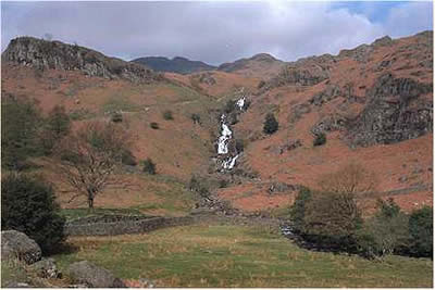
Click image to visit gallery of 3 images.
This Lake District walk visits two fells of contrasting character. High Raise is a substantial fell just reaching an elevation of 2,500ft. With a featureless summit, High Raise is usually only seen by fell walkers, which contrasts sharply with Helm Crag. Often called the "Lion and the Lamb", Helm Crag is not as lofty although its summit is much more memorable even to the hordes of car-bound tourists passing through Grasmere each year. Considering the terrain, this is a hard walk with a considerable amount of ascent. However it is an excursion where your efforts are well rewarded with a variety of scenery with views over much of the Lake District.
The walk can start from any of the main car parks in Grasmere village although the most convenient is the small "pay and display" on the right hand side along the Easedale Road (grid ref. NY335078). From here continue west along the lane until you reach a bend where you take the footpath signed Easedale Tarn. The path starts level but soon climbs providing an excellent prospect of Sourmilk Gill as it tumbles down to the valley from its outlet in Easedale Tarn. The Tarn was once a popular place for Victorians and even today many visitors make the effort to reach this tranquil spot. Following the south shore of the Tarn the path resumes its ascent leading to Belles Knot, a rather attractive "mini-fell" on the right hand side if the path. From here a short detour takes you to the even quieter shores of Codale Tarn, which nestles in the lee of Ling Crag and Tarn Crag.
The path steepens and becomes rougher as you continue to a col. This important crossroads (grid ref. NY292084) provides your first sight of the Langdale Pikes and Stickle Tarn with Pavey Ark prominent in the view. Turning right (north-west) the next objective is the rocky summit of Sergeant Man which although lower in altitude than High raise is a much more interesting place to linger.
Having taken your fill of the scenic panorama continue north-west to the summit cairn of High Raise, which in itself is eminently boring although it does provide good views to the north and north-west. Turning north to Low White Stones the path veers north-east as you head down the peaty slopes of Greenup Edge to meet the path coming up from Watendlath. The next section is often horribly wet and boggy with a slight descent and re-ascent to the col at the western end of Far Easedale.
If time is tight or your energy levels are falling then an easy escape id to drop down into Far Easedale and head directly back to Grasmere on the valley path. Infinitely more interesting is to keep to the high ground and follow the ridge linking Calf Crag to Gibson Knott and Helm Crag. This an excellent ridge walk although it can be boggy with many diversions necessary to avoid the worst of the soggy peat. However the view more than compensates for this annoyance as you twist and turn along the ridge. Ahead lie the high fells of the Fairfield Horseshoe with Sleet Fell dominating the view to your immediate left.
Your arrival at Helm Crag seems to take longer than the map might suggest although the summit is instantly recognisable from upstanding rocks, which are easily visible from the road and Grasmere. Deciding which is "the Lion" and which is "the Lamb" is a hard task and even with much deliberation I am still not sure if we got it right! Care needs to be exercised around the summit as there are some serious crags to contend with on both the northern and southern flanks of the fell. Descend by the main path, which has seen considerable work in recent years to emerge in the valley. Turn left onto the lane and follow this back to Grasmere.
Other walks nearby
| Walk 3625 | Silver How from Grasmere | easy | 3.2 miles |
| Walk 1154 | Between Grasmere and Langdale | moderate | 9.5 miles |
| Walk 1472 | Alcock Tarn & Rydal Water | easy/mod | 7.0 miles |
| Walk 1565 | Rydal Water & Grasmere circular | easy/mod | 6.0 miles |
| Walk 1682 | Rydal Water & Grasmere | easy/mod | 5.5 miles |
| Walk 2254 | Grisedale Tarn | moderate | 5.5 miles |
| Walk 2841 | Seat Sandal via Grisedale Tarn from Grasmere | moderate | 5.0 miles |
| Walk 2932 | Green Burn horseshoe from Grasmere | moderate | 7.0 miles |
| Walk 1823 | Fairfield Horseshoe & Loughrigg from High Close | mod/hard | 14.0 miles |
| Walk 2715 | Skelwith Bridge & Loughrigg | easy/mod | 5.5 miles |
Recommended Books & eBooks
Lake District: High Level and Fell Walks
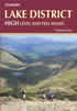 This guidebook describes 30 graded fell walks on the ridges and high peaks of the English Lake District, the UK's most popular national park. Reaching some of England's finest and highest mountain scenery, this guide leads readers to classic horseshoes and traditional ascents as well as lesser-known routes to quieter summits.
More information
Walking the Lake District Fells - Keswick
 Part of the Walking the Lake District Fells series, this guidebook covers a wide range of routes to 30 Lakeland summits that can be climbed from Keswick, Whinlatter, Bassenthwaite, Caldbeck, Mungrisdale and Threlkeld, with highlights including Skiddaw and Blencathra. Includes suggestions for longer ridge routes.
More information
Messaging & Social Media
Message Walking Britain and follow the latest news.

Mountain Weather
Stay safe on the mountains with detailed weather forecasts - for iOS devices or for Android devices.