Shining Tor & Axe Edge Moor from Cat & Fiddle
Peak District Walk
Nat Park - Peak District - Goyt Valley Lyme Park
County/Area - Cheshire & Derbyshire & Staffordshire
Author - Lou Johnson
Length - 9.0 miles / 14.6 km Ascent - 1300 feet / 394 metres
Time - 5 hours 50 minutes Grade - moderate
Maps 

| Ordnance Survey Explorer OL24 | Sheet Map | 1:25k | BUY |
| Anquet OS Explorer OL24 | Digital Map | 1:25k | BUY |
| Ordnance Survey Landranger 119 | Sheet Map | 1:50k | BUY |
| Anquet OS Landranger 119 | Digital Map | 1:50k | BUY |
| Ordnance Survey Landranger 118 | Sheet Map | 1:50k | BUY |
| Anquet OS Landranger 118 | Digital Map | 1:50k | BUY |
Walk Route Description
Click image to visit gallery of 4 images.
For many Cheshire is never associated with high ground, yet this walk starts from opposite the "Cat & Fiddle" public house on the A537 Buxton to Macclesfield road (grid ref. SK001719). At just over 510 meters above sea level, this pub is one of the highest in Britain and, when the weather is fine, provides a good view over the surrounding moors. Although predominantly moorland in character, this Peak District walk includes three counties - Cheshire, Derbyshire and Staffordshire - with wide ranging views for most of its length.
There is usually plenty of roadside parking available opposite the pub. From here you need to follow the track heading north west on the same side of the road from the pub. After a short way a footpath is signed on your right and you should follow this northwards. Reaching the first cross path keep straight - you will return here so take note. Keep ahead until after a short way you reach another junction where you turn left to head to the summit of Shining Tor - at 559 metres this is the highest land in Cheshire (although the eastern half is in Derbyshire!). Enjoy the extensive view and retrace your steps to the first junction mentioned above.
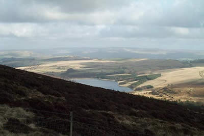
From the junction head downhill with good views across to Errwood Reservoir. Follow the edge of a conifer plantation, avoiding the worst of the boggy sections, to enter the plantation. Cross Deep Clough and continue for a few hundred metres before turning down left to the road that follows Goyt's Clough. Below you there is a footbridge and after crossing this head roughly east towards Berry Clough. The climb is steady and the views improve with height. At the path junction (grid ref. 027727) turn south to reach a track. Pick up the onward path that continues in the same direction to reach the A54. The walking is easy and the Western Moors, as this part of the Peak District is often called, stretch out into Cheshire and Staffordshire.
From the main road continue south across Axe Edge Moor to cross a minor road at Dane Head. Away to your right the shapely outline of Shuttlingsloe (the Cheshire Matterhorn) can be seen on the horizon. Stay in roughly the same direction to follow good paths across the flanks of Cheeks Hill and Orchard Common. Then turn left uphill through Orchard Farm where the path goes through a rather muddy yard, which on this occasion was occupied by a large herd of Highland Cattle! Stay with the track as this contours around the hillside to Reeve-edge Quarries where remnants of the final day's production are still in evidence. Reaching a stream the path turns west and climbs steeply out of the valley/quarry to reach the A54. Here you take the signed path heading northwest across moorland to return to the "Cat and Fiddle".
Other walks nearby
| Walk 1728 | Axe Edge Moor & Three Shires Head | easy/mod | 7.2 miles |
| Walk 3136 | Shining Tor & Goyt's Clough | easy/mod | 5.1 miles |
| Walk 1652 | Three Shires Head | easy | 4.5 miles |
| Walk 2233 | Flash & Three Shires Head | easy/mod | 6.2 miles |
| Walk 1092 | Taxal Edge, Jenkin Chapel & Pym Chair | moderate | 8.5 miles |
| Walk 2576 | Fernilee Reservoir, Goyt Valley | easy | 6.0 miles |
| Walk 3510 | Shining Tor, Cats Tor & Foxlow Edge | easy/mod | 7.0 miles |
| Walk 2272 | Flash Circular from Cistern Clough | moderate | 8.0 miles |
| Walk 2506 | Tegg's Nose from Trentabank | moderate | 7.5 miles |
| Walk 2535 | Wildboarclough & Shutlingsloe from Trentabank | moderate | 7.0 miles |
Recommended Books & eBooks
Great Mountain Days in the Pennines
 An inspirational guidebook to 50 classic walks on the rolling Pennine landscape. The graded routes, between 6 and 13 miles in length, cover classic Pennine fells and moorland such as Whernside, Ilkley Moor and Pendle Hill; exploring the North and South Pennines, Yorkshire Dales, Howgills and Dark Peak. Many routes are also suited to fell running.
More information
Dark Peak Walks
 Guidebook to 40 walks in the Dark Peak area of the Peak District National Park. 35 circular routes for most abilities, from 8km to 19km, around Edale, Marsden, Fairholmes, Baslow and Castleton, including Kinder Scout and Mam Tor, and 5 longer (25km to 45km) routes highlighting the best of the Gritstone Edges, High Moorland and Deep Valleys.
More information
Messaging & Social Media
Message Walking Britain and follow the latest news.

Mountain Weather
Stay safe on the mountains with detailed weather forecasts - for iOS devices or for Android devices.