Beamsley Beacon and Bolton Abbey from Addingham
Yorkshire Dales Walk
Nat Park - Yorkshire Dales - Lower Wharfedale
County/Area - West Yorkshire & North Yorkshire
Author - Peter Schofield
Length - 10.0 miles / 16.3 km Ascent - 1600 feet / 485 metres
Time - 6 hours 40 minutes Grade - moderate
Maps 

| Ordnance Survey Explorer OL2 | Sheet Map | 1:25k | BUY |
| Anquet OS Explorer OL2 | Digital Map | 1:25k | BUY |
| Ordnance Survey Landranger 104 | Sheet Map | 1:50k | BUY |
| Anquet OS Landranger 104 | Digital Map | 1:50k | BUY |
Walk Route Description
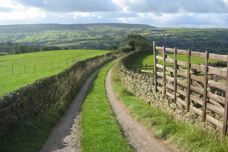
Click image to visit gallery of 6 images.
This Yorkshire walk explores an area on the southern edge of the National Park and has a bit of everything. Rolling pastureland, wild moorland, riverscapes and historic buildings can all be found within a relatively short distance.
The walk starts in Addingham at the suspension footbridge over the River Wharfe (grid ref. SE083499). Cross the bridge and follow the path to West Hall Lane. Continue up the lane for 100m and go through a gate as the lane turns left. Continue uphill across the fields to arrive at a narrow and occasionally wet walled path which gently climbs towards a farm (grid ref. SE093513). Go around the front of the farmhouse on to a quiet lane.
Turn left on to the lane and as it turns right after 150m, bear slightly left down a track towards a finger post. Take the upper path indicated on the finger post over a stile and through a copse as the path crosses a number of fields, entering the Dales National Park at the second field boundary. To the right Beamsley Beacon is prominent while views open out to the left towards Airedale and Flasby Fell.
The path finally reaches a very narrow stile to arrive at the access road to Howber Hill Farm. Keep straight on across both the track and a minor road as views open out to the left towards Bolton Bridge and Wharfedale. The occasionally damp path joins a vehicle track, continuing to a junction where a finger post directs you to along a track to the right towards Howgill Side and Howgill Farm. Stay on this track until 100m beyond Howgill Farm where a path bears left to follow a wall down to a footbridge over Kex Beck. Beyond the bridge, the route climbs steeply up a walled lane to arrive at the A59 road at Hill End (grid ref. SE095540).
Take care to cross this very busy road and continue down the lane opposite to a fork in the road near some houses. Take the right fork up the hill and after 120m, double back on to a walled lane which climbs to reach the access track to Witchey (grid ref. SE091541). Note the change in the terrain. The pastures seen earlier have been left behind and the open moorland is more reminiscent of the Dark Peak. Follow the clear route past Witchey as it winds over the moor to reach a finger post at a track junction (grid ref. SE093551). It's worth having a break here to enjoy the expansive views towards Barden Fell, Simons Seat and across Wharfedale.
Turn left and as the track descends gently, the Cavendish Pavilion and River Wharfe can be seen down below on the right. The track continues descending to arrive at a road at the hamlet of Storiths. Go right along the road and after 200m, go left down a quiet lane to a finger post (grid ref. SE080542). Turn right and then left past a farmhouse to join a walled path descending steeply as the ruins of Bolton Abbey come into view ahead. Where the path meets another path at a gate, turn left and follow the path as it descends towards the river bank and crosses several fields to arrive at a quiet road just east of Bolton Bridge. Turn right and cross the now practically disused bridge as the traffic thunders across a more modern bridge a short distance downstream.
At this point the walk can be shortened by turning left on to the Dales Way just beyond the bridge and following it back to the start at Addingham. However our route continues straight ahead to the B6160. Turn left and after 70m, go right at a finger post through a field to another gate on the A59. Cross the road and continue up the tarmac road opposite as it climbs up to Hawpike Farm. Follow the track through the farm buildings as it bears left through a gate. Continue to follow the track for 150m to just beyond a gully and then go left to follow a faint path along the top side of Lob Wood on a bearing of 135 degrees.
The route continues on roughly the same bearing over a couple of stiles as views open out towards Beamsley Beacon and other points seen earlier the walk. Descending gently the route arrives at a gate next to a disused railway line at SE072517. After 80m turn left on a track which passes through extensive riding stables to arrive at the B6160. The Friends Meeting House here dates back to 1669 and is well worth a look. Cross the road and go down the steps on to the Dales Way, following this well walked route back to the start in Addingham.
This walk is suitable for those without their own transport as Addingham is well served by buses. Frequent services link the village centre with Ilkley, Skipton, Leeds, Keighley and Grassington and timetable details can be found on www.wymetro.com. The start and finish point is in Bark Lane about five minutes walk from the main bus stop.
Other walks nearby
| Walk 2942 | Below Silsden Moor | easy/mod | 6.8 miles |
| Walk 2574 | Valley of Desolation & Barden Fell | moderate | 11.0 miles |
| Walk 2319 | Ilkley to Bingley | easy/mod | 7.0 miles |
| Walk 1001 | Barden Bridge & the Strid | easy | 4.0 miles |
| Walk 1249 | Simon's Seat | moderate | 10.0 miles |
| Walk 3079 | Silsden Reservoir circular | easy | 6.0 miles |
| Walk 3114 | Haystacks, Twelve Apostles & Idol Stone of Ilkley Moor | easy/mod | 4.5 miles |
| Walk 3215 | Steeton to Ilkley without a car | moderate | 7.5 miles |
| Walk 1946 | Valley of Desolation & Simon's Seat | moderate | 8.4 miles |
| Walk 3430 | Farnhill Moor from Kildwick | easy/mod | 4.5 miles |
Recommended Books & eBooks
Walking in the Yorkshire Dales: North and East
 This guidebook contains 43 circular day walks in the north and east Yorkshire Dales. It explores the dales, hills and moors between Kirkby Stephen and Pateley Bridge. Walking ranges from gentle 3 mile strolls to more strenuous day-long rambles across the Howgills, Wensleydale, Swaledale, Nidderdale, Mallerstang and Coverdale.
More information
Walking in the Yorkshire Dales: South and West
 Part of a two-book set, this guidebook describes 44 walks in the southern and western Yorkshire Dales, including the famous 23 mile Three Peaks circuit over Pen-y-Ghent, Whernside and Ingleborough. The other, mostly circular routes of 3½ to 13 miles cover the scenic region between Sedbergh, Kirkby Lonsdale, Settle, Skipton and Grassington.
More information
Messaging & Social Media
Message Walking Britain and follow the latest news.

Mountain Weather
Stay safe on the mountains with detailed weather forecasts - for iOS devices or for Android devices.