Pin Mill to Shotley Gate
Suffolk Coasts and Heaths Walk
Region - Suffolk Coasts and Heaths
County/Area - Suffolk
Author - Suffolk Coast & Heaths AONB
Length - 5.5 miles / 8.9 km Ascent - 50 feet / 15 metres
Time - 2 hours 50 minutes Grade - easy
Maps 

| Ordnance Survey Explorer 197 | Sheet Map | 1:25k | BUY |
| Anquet OS Explorer 197 | Digital Map | 1:25k | BUY |
| Ordnance Survey Landranger 156 | Sheet Map | 1:50k | BUY |
| Anquet OS Landranger 156 | Digital Map | 1:50k | BUY |
Walk Route Description
Click image to visit gallery of 2 images.
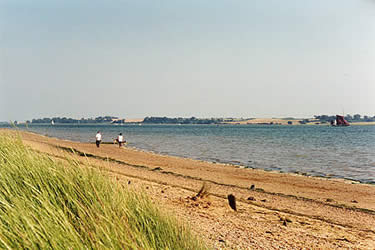
This gentle riverbank walk, adored by artists, birdwatchers and walkers alike, offers an excellent insight into the contrasts of the Stour and Orwell estuaries. Internationally important wildfowl and wader colonies feed close by some of the world's largest container ships, while bright new dinghies anchor beside historic Thames barges.
In the heart of the Suffolk Coast & Heaths Area of Outstanding Natural Beauty, this walk forms part of the Stour & Orwell Walk, a 68-km (42-mile) long distance footpath adjoining the Suffolk Coast & Heaths Path to the north. Allow around 3 hours for walking plus plenty of time for stops, as there is much to see on the way. Walking boots are recommended, as the route can be wet in places.
The path can be reached by bus 97 from Ipswich railway station descending at Chelmondiston; a link path beside the church takes you on to the estuary and the 17the century 'Butt and Oyster' public house in the tiny hamlet of Pin Mill. This attractive village should not be hurried through. In the last century Arthur Ransome penned some of his great sailing stories here, while in the 19th century Pin Mill was a haven for smugglers and busy staging point for ship borne cargo, with numerous red-sailed barges trading up and down the estuary. Today the village is a popular sailing centre and host to the magnificent annual Thames sailing barge race.
This linear walk starts from the car-park at Pin Mill (grid ref TM206379), a flight of steps takes one down to the pub and the foreshore, from there turn right along the shore to Pin Mill Cliff, a woodland dominated by old alder coppice. Clearings close to the shore allow excellent views across the river to the mudflats below Naction, important for waders and wildfowl include Curlew and Brent Geese. Just past Clamp House the path moves inland avoiding the marshy inlet of Long Reach, where one can take an alternative footpath leading back to the road to Chelmondiston. After passing a small copse the footpath returns to the riverbank and travels round the headland, with magnificent views across the river to Loompit Lake.
The low lying fresh water meadows behind the river wall at Shotley Marshes is the county's top breeding site for wading birds such as Lapwing, Snipe and Redshank. Here a short diversion takes one to Shotley Church, delightfully positioned on high ground overlooking the estuary. The building is a blend of medieval and classical architecture; the exquisite chancel of 1745 and mildly Rococo altarpiece are well worth a look.
The Anglo Saxon settlement of Shotley Gate saw its first naval battle in AD 885 when Alfred, King of Wessex, fought off Guthrum the Dane's invading army. In 1861 HMS Ganges was established as a cadet training ship and docked off Harwich. In 1904 a land based training centre was establishing in Shotley Gate where 150,000 cadets marched across its parade ground before it closed in 1976.
From here you can view the confluence of the two estuaries; Felixstowe Port with its massive cranes and container ships and Harwich's European passenger ferries. The 97 bus stops outside the Bristol Arms and takes one to Ipswich railway station. Alternatively you might like to take the foot ferry that crosses between Harwich, Shotley Gate and Felixstowe throughout the summer. From Felixstowe there is a good rail service to Ipswich.
Other walks nearby
| Walk 2374 | Freston Circular | easy/mod | 6.6 miles |
| Walk 1648 | Church End & Erwarton from Shotley Gate | easy | 6.0 miles |
| Walk 2096 | Alton Water, Stutton & Tattingstone | easy | 5.5 miles |
| Walk 2149 | Circuit of Alton Water | easy/mod | 7.6 miles |
| Walk 3267 | Ramsholt, River Deben and Shottisham Circular | easy/mod | 9.2 miles |
| Walk 3658 | Manningtree, Flatford Mill and Dedham | easy/mod | 7.1 miles |
| Walk 3660 | Stour Valley & Dedham from Flatford Mill | easy | 3.5 miles |
| Walk 2366 | The Naze from Walton-on-the-Naze | easy | 6.0 miles |
| Walk 3724 | River Box from Stoke-by-Nayland | easy | 6.0 miles |
| Walk 2428 | The Rivers Ore & Alde from Orford | easy/mod | 11.0 miles |
Recommended Books & eBooks
Suffolk Coast and Heath Walks
 Guidebook to three long-distance routes exploring the varied landscapes of the Suffolk Coast and Heaths AONB. The Suffolk Coast Path covers 55 to 60 miles from Lowestoft to Felixstowe. The Stour and Orwell Walk is 40 miles from Felixstowe to Cattawade near Manningtree, while the Sandlings Walk is 59 miles from Ipswich to Southwold.
More information
Messaging & Social Media
Message Walking Britain and follow the latest news.

Mountain Weather
Stay safe on the mountains with detailed weather forecasts - for iOS devices or for Android devices.