Grisedale Tarn from Grasmere
Lake District Walk
Nat Park - Lake District - Lake District Eastern Fells
County/Area - Cumbria
Author - Lou Johnson
Length - 5.5 miles / 8.9 km Ascent - 1980 feet / 600 metres
Time - 4 hours 40 minutes Grade - moderate
Maps 

| Ordnance Survey Explorer OL5 | Sheet Map | 1:25k | BUY |
| Anquet OS Explorer OL5 | Digital Map | 1:25k | BUY |
| Ordnance Survey Landranger 90 | Sheet Map | 1:50k | BUY |
| Anquet OS Landranger 90 | Digital Map | 1:50k | BUY |
Walk Route Description
Click image to visit gallery of 6 images.
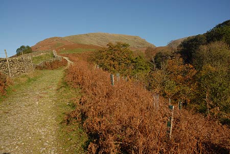
Grisedale Tarn is dramatically located between high fells. It makes an excellent objective for those who wish to get into the mountains yet do not want to make a full ascent of a hill or mountain. This Lake District circular walk follows paths that are easy to follow and apart from one section of fairly steep ascent on the outward section, the going is generally fairly easy.
The start is one mile north along A591 from Grasmere at Mill Bridge (Grid ref. NY336091). Parking is available in two lay-bys and a few other places although there are restrictions at certain times of the year. At busy times of the year an early start is essential. As an alternative there is the frequent bus service between Windermere, Ambleside and Keswick passing the start. After parking locate the bridleway (signed Patterdale) on the east side of the main road almost opposite the lane leading down towards Low Mill Bridge.
The bridleway climbs gently with Tongue Gill below on your right. Ahead the slopes of Seat Sandal rise quite steeply. Cross the first footbridge (Grid ref. NY339098) and immediately bear left to continue with Little Tongue Gill on your left. At first the ascent is gentle but it soon becomes steeper. With approximately 600 feet of ascent onto the flank of Seat Sandal, the path eventually becomes more or less level and contours across the side of the hill. Below and to your right, you will see the path coming up alongside Tongue Gill. This path crosses beneath the foot of the waterfall and it is worth noting where this path joins yours as this is the return route.
Keeping ahead past a large depression on your right, the path climbs through a boulder field for a final short ascent to Grisedale Hause. From here you get your first sight of Grisedale Tarn, which is surrounded by high fells including Fairfield, Dollywaggon Pike, St.Sunday Crag and Seat Sandal. It is worth following the path around the Tarn as this offers a number of views that you will otherwise miss. It also enables you to select a good spot to rest and enjoy the location.
To return to the start climb back up to the Hause and descend through the depression to where the paths divide. Bear left and descend on a path that is paved in sections to pass the foot of the waterfall seen during the ascent. The path then descends gradually with Tongue Gill below on your right. Ahead you get a good view of Helm Crag with other higher fells in the distance. Reaching the concrete reservoir, bear right down to the gill. Cross both footbridges and retrace your steps along the track to the start.
Other walks nearby
| Walk 1111 | High Raise & Helm Crag | mod/hard | 9.5 miles |
| Walk 3625 | Silver How from Grasmere | easy | 3.2 miles |
| Walk 1154 | Between Grasmere and Langdale | moderate | 9.5 miles |
| Walk 1472 | Alcock Tarn & Rydal Water | easy/mod | 7.0 miles |
| Walk 1565 | Rydal Water & Grasmere circular | easy/mod | 6.0 miles |
| Walk 1682 | Rydal Water & Grasmere | easy/mod | 5.5 miles |
| Walk 1823 | Fairfield Horseshoe & Loughrigg from High Close | mod/hard | 14.0 miles |
| Walk 2026 | Loughrigg from Pelter Bridge near Rydal | easy/mod | 4.0 miles |
| Walk 2715 | Skelwith Bridge & Loughrigg | easy/mod | 5.5 miles |
| Walk 1684 | Lingmoor Fell & Langdale | easy/mod | 7.0 miles |
Recommended Books & eBooks
Walking the Lake District Fells - Buttermere
 Part of the Walking the Lake District Fells series, this guidebook covers a wide range of routes to 32 Lakeland summits that can be climbed from the Buttermere, Lorton and Newlands valleys, with highlights including Haystacks, High Stile, Grasmoor and the fells of the Coledale Round. Suggestions for longer ridge routes are also included.
More information
Walking the Lake District Fells - Keswick
 Part of the Walking the Lake District Fells series, this guidebook covers a wide range of routes to 30 Lakeland summits that can be climbed from Keswick, Whinlatter, Bassenthwaite, Caldbeck, Mungrisdale and Threlkeld, with highlights including Skiddaw and Blencathra. Includes suggestions for longer ridge routes.
More information
Messaging & Social Media
Message Walking Britain and follow the latest news.

Mountain Weather
Stay safe on the mountains with detailed weather forecasts - for iOS devices or for Android devices.