Marden & Sutton St.Nicholas from Moreton-on-Lugg
Herefordshire Walk
County/Area - Herefordshire
Author - Allan Friswell
Length - 7.5 miles / 12.2 km Ascent - 300 feet / 91 metres
Time - 4 hours 0 minutes Grade - easy/mod
Maps 

| Ordnance Survey Explorer 202 | Sheet Map | 1:25k | BUY |
| Anquet OS Explorer 202 | Digital Map | 1:25k | BUY |
| Ordnance Survey Landranger 149 | Sheet Map | 1:50k | BUY |
| Anquet OS Landranger 149 | Digital Map | 1:50k | BUY |
Walk Route Description
Click image to visit gallery of 5 images.
The village is signed on the left a couple of miles before you reach Hereford along the A49. The former railway station at Moreton was famous for having the ticket office situated in a huge hollow oak tree with a circumference of 9 m. On the other side of the River Lugg lies Freens Court, investigated by the TV programme Time Team in 1999 as a possible site for the Saxon palace of King Offa. The dig confirmed the existence of a large aisled building but it was thought to date from the mediaeval period. An area north of the village was used for many years by the Royal Army Ordnance Corps, and the internal railway at the RAOC site was used for training SAS troops to attack railway carriages. The village has a shop and a famous chippie, but no pub.
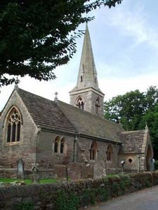
Park considerately in the village centre. Walk in an easterly direction, passing over the railway crossing, and Moreton Bridge over the Lugg River with its triangular passing recesses/breakwaters. Take the footpath on the left. Cross the meadow veering half right, passing the willow trees on your left, and making for the stile about 25 yards to the left of a solitary tree. Go straight ahead to the metal gate by the power pole, then maintain your line to the concrete bridge and gate. Cross the next meadow at veering slightly right, crossing beneath power lines and making for a distant telegraph pole. A stile and gate take you close to the main road. Turn left and make for Marden Church. Walk round to the rear and follow the footpath (signed but often very muddy) through the church grounds which are full of snowdrops in February. A lovely sight.
Go over two stiles, the second being up a slight incline on your right. Forward to the next stile, then keep ahead with the hedge on your right. Where the power poles end, go through the metal kissing gate, following the path down the side of a house. Passing through three more such gates, you arrive at Laystone Bridge. Here you turn right and walk to the junction, where you again go right (Orchard Green - signed Moreton on Lugg) and go to the T junction where you turn left along Paradise Road. Do not fail to go into the Polish shop on the immediate left if you want a strong lager or some sausage!
Follow your nose, past the recreation ground., the Post Office (and pukka village shop!) and 150 yards further on, just before the 30 mph repeater sign, cross over and climb the signed stile (Grid ref. SO529477). Cross the large field walking half right, aiming for the double stile and footbridge at the foot of the power pole in the hedge (Grid ref. SO 530476). Go over the next field walking slightly right to the stile, go over the lane and negotiate another stile. Your steps now take you left to the far left hand corner of the field where a bungalow and power pole and stile await you. Turn right (Grid ref. SO531470). Walk along this pleasant quiet lane to the junction with the main road, where you turn right and walk about ½ mile down into Sutton St Nicholas, passing the new primary school on your left (In my day Primary Schools didn't involve buildings looking like small technical colleges?).
You may care for a pint at the Golden Cross pub. Otherwise turn right at the crossroads towards Marden. After about 300 yards, opposite Ordis Cottage 1, take the right hand bridleway signed to Ordis Court. The track climbs gently to a signpost, where you ignore the bridleway leading right and carry on climbing ahead, following the left hand hedge. A few yards after the crest of the hill take the path on the left through the trees. This brings you to the track which surrounds the site of the Sutton Walls Iron Age Fort. Turn right and follow until you eventually reach a tarmac and concrete track leading downhill. If conditions allow and you are nimble enough, clamber up the steep side to reach the cropped over plateau, which you can walk round anti-clockwise admiring the ideal position the fort occupied. Eventually you will reach the tarmac/concrete track.
One of the scandals of British archaeology, this elongated ovoid fort has had much of its interior removed for gravel. This left a quarry used as a dump for toxic waste. The first occupation of the site in the early Iron Age did not involve defences. By 100 BC, a V-shaped ditch and an internal bank revetted with timber and drystone had been built, and huts were constructed later. Around AD 25, the defences were strengthened; but in AD 48, 24 people were killed - probably by the Romans - and thrown into the ditch: their unearthed skeletons at the west end of the fort bear wounds, and some were decapitated. The skeletons of these young men averaged 5'8", which was actually taller than the average height of men in the 1950s when Kathleen Kenyon excavated them.
Descend this track due south to the hamlet of Sutton Saint Michael, where you turn left and almost immediately right at Pool House, following the tarmacked track. Where it forks right, you should keep ahead along the green track as far as the gates, where you go through that on the left and then cross the stile. Keeping the woods quite close on your right, you come to a footbridge (SO 520458) which you will need to be a member of the SAS to get on to. Once over this veer slightly right and follow a fairly obvious path which keeps just to the right of a drainage ditch, and which takes you to a stile. Cross the enormous field, making for the right hand corner, the road, and Moreton Bridge which you cross and walk back into Moreton.
Other walks nearby
| Walk 2365 | Mordiford & Hampton Bishop Circular | easy/mod | 7.6 miles |
| Walk 3014 | Leominster Circular | easy | 5.0 miles |
| Walk 2192 | Wye Valley Walk | easy/mod | 6.6 miles |
| Walk 1516 | Pershore Circular | easy/mod | 8.3 miles |
| Walk 1787 | Pembridge, Eardisland & the Arrow Valley | easy/mod | 7.4 miles |
| Walk 1950 | Golden Valley - Hardwicke to Dorstone | moderate | 11.4 miles |
| Walk 2179 | Merbach Hill | easy/mod | 6.5 miles |
| Walk 2817 | The Marcle Ridge from Much Marcle | easy/mod | 7.0 miles |
| Walk 1673 | Shobdon Hill and Croft Ambrey from Shobdon Estate | moderate | 12.5 miles |
| Walk 3243 | Garway Hill Common & Kentchurch | easy/mod | 6.3 miles |
Recommended Books & eBooks
No suggestions for this area.Messaging & Social Media
Message Walking Britain and follow the latest news.

Mountain Weather
Stay safe on the mountains with detailed weather forecasts - for iOS devices or for Android devices.