Chun Quoit and Botallack from Carnyorth
Cornwall AONB Walk
Region - Cornwall AONB
County/Area - Cornwall
Author - Lou Johnson
Length - 8.0 miles / 13 km Ascent - 900 feet / 273 metres
Time - 4 hours 50 minutes Grade - moderate
Maps 

| Ordnance Survey Explorer 102 | Sheet Map | 1:25k | BUY |
| Anquet OS Explorer 102 | Digital Map | 1:25k | BUY |
| Ordnance Survey Landranger 203 | Sheet Map | 1:50k | BUY |
| Anquet OS Landranger 203 | Digital Map | 1:50k | BUY |
Walk Route Description
Click image to visit gallery of 2 images.
The far west of Cornwall is dominated by Land's End even though there are far more interesting things to see. This Cornwall walk combines Neolithic history, industrial heritage and great scenery yet avoids the crowds. Parking is available in the centre of Carnyorth (Grid ref. SW 374333), which is located on the B3306 St Ives to St Just road.
After parking, taking care not to cause obstruction, head up the lane towards the radio mast to cross a waymarked stile that leads into fields. Cross the fields keeping the mast ahead to reach a track. The views behind you are improving as height is gained. Reaching the mast you will see a tor ahead, Carn Kenidjack, and this is your next objective. Follow the path that leads to the left of this tor and head east, at first on a path and then along a track.
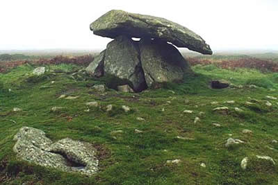
Cross the B3318 and east continue across pleasant moorland. Chun Quoit is a Neolithic tomb and it can be seen to the left of the hill ahead. From the Quoit there are excellent all round views which improve again if you climb to the summit of the hilltop fort of Chun Castle. From the Quoit head north on the clear path with Morvah Church ahead. The path leaves the moor and joins a track, which is followed as far as Carne Farm.
Just before the farmyard take the signed footpath on the left. This leads across fields to reach the main road. Take the path to the right of the church. This path twists down to the sea to reach the coastal footpath where you turn left. Looking east the view is superb with Trevowhan and Trevean cliffs plunging down to the sea. The path drops down to Portheras beach before a steep climb leads you up to Pendeen Watch.
The lighthouse, which provided warning of this dangerous headland, is now open to visitors. Throughout the centuries a great number of ships came to grief in the immediate area and some historians suggest that it was one of the worst places in Cornwall for disasters at sea. Follow the road from the lighthouse to the terrace of cottages that were built to house the lighthouse keepers. Just past the end of the terrace rejoin the coastal path.
Your onward route stays near the cliff tops before winding through the ruins of Levant Mine. The advent of tin mining brought prosperity to the area although the days of profitable enterprise have long since passed. Of interest of the Levant beam-engine, which has been restored by the National Trust and is open for public viewing during the season. Occasionally steamed up it is possible to see this wonderful piece of equipment in operation.
Stay on the coastal footpath to reach a house on your left called Roscommon. There are superb views ahead of cape Cornwall but far below you on the right are the dramatic ruins of the engine-houses at Botallack from where mining extended far out to sea. We leave the coastal path and head inland into the village of Botallack to reach the main road. Turn left along the road and left again through a gap in the cottages to a stile. With the wall on your left continue across fields to reach your starting point.
Other walks nearby
| Walk 3325 | Chun Quoit & Carn Kenidjack | easy | 4.0 miles |
| Walk 1225 | Sennen Cove & Botallack from St Just | moderate | 7.5 miles |
| Walk 2616 | The moors and hills of Penwith | moderate | 14.0 miles |
| Walk 1224 | Men-an-tol & Ding Dong Mine | easy | 3.0 miles |
| Walk 2614 | St Loy's Cove & Logan Rock | moderate | 8.5 miles |
| Walk 1081 | Zennor & St Ives coast path | mod/hard | 11.0 miles |
| Walk 1223 | Morvah to Zennor coast | moderate | 5.5 miles |
| Walk 2205 | Newlyn - a village trail | easy | 1.0 miles |
| Walk 2207 | Penzance - a town stroll | easy | 1.5 miles |
| Walk 2354 | Merry Maidens & Lamorna Cove | easy | 4.1 miles |
Recommended Books & eBooks
The South West Coast Path
 Guidebook to walking the entire South West Coast Path National Trail. The route runs for 630 miles from Minehead to Poole along the north Devon, Cornish, south Devon and Dorset coastline. Divided into 45 stages, this long-distance coastal trek could be completed within 4 weeks, or walked in sections. Guide includes maps and essential information.
More information
South West Coast Path Map Booklet - St Ives to Plymouth
 Map of part of the southern section of the 630 mile (1014km) South West Coast Path National Trail. Covers the trail from St Ives to Plymouth along the west Cornwall and Devon coastline. This convenient and compact booklet of Ordnance Survey 1:25,000 maps shows the route, providing all of the mapping you need to walk the trail in either direction.
More information
Messaging & Social Media
Message Walking Britain and follow the latest news.

Mountain Weather
Stay safe on the mountains with detailed weather forecasts - for iOS devices or for Android devices.