Longsleddale and Kentmere Pike from Sadgill
Lake District Walk
Nat Park - Lake District - Lake District Far Eastern Fells
Wainwrights - Harter Fell, Kentmere Pike, Shipman Knotts
County/Area - Cumbria
Author - Lou Johnson
Length - 8.0 miles / 13 km Ascent - 2145 feet / 650 metres
Time - 6 hours 10 minutes Grade - moderate
Maps 

| Ordnance Survey Explorer OL7 | Sheet Map | 1:25k | BUY |
| Anquet OS Explorer OL7 | Digital Map | 1:25k | BUY |
| Ordnance Survey Landranger 90 | Sheet Map | 1:50k | BUY |
| Anquet OS Landranger 90 | Digital Map | 1:50k | BUY |
Walk Route Description
Click image to visit gallery of 4 images.
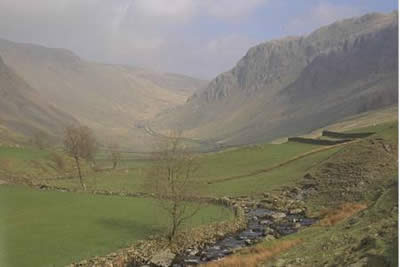
Relatively unfrequented, the Lake District valley of Lonsleddale is a wonderful place to be. As its name suggests, it is a long valley starting from the A6 to the north of Kendal at Garnett Bridge and continuing for five or six miles to Sadgill where vehicular access ends. The valley then continues for a further three miles to the summit of Gatescarth Pass.
The upper reaches of the valley are impressive. After parking on the verges at Sadgill (grid ref. NY 483056) you need to follow the old quarry road between walls as it heads north to Gatescarth Pass. The walled lane climbs gently for most of its length although it does steepen as you climb past Raven Crag. Alongside, the waters of the infant River Sprint cascade through a rocky cleft as they head towards the sea.
The path flattens as you reach Wrengill Quarry and this is a perfect place to rest and enjoy the solitude of this wild corner of the Lake District. Suitably refreshed continue north to the summit of Gatescarth Pass, getting your first sight of Mardale and Haweswater Reservoir.
Turning west the ascent of Harter Fells begins. The climb is interesting without being too exhausting with ever improving views into Mardale and across to High Street and Blea Water. Reaching the summit cairn, constructed from old iron fence posts, you follow the fence as it heads south to Kentmere Pike. The views have changed as has the terrain. To your right is the rocky Nan Bield Pass, backed by Mardale Ill Bell, and you can now trace the ridge from Thornthwaite Beacon over Froswick and Ill Bell to Yoke. This is Lake District walking at its best.
Occasionally boggy, the path to Kentmere Pike is perfect for setting a fast pace and you have soon conquered the second "Wainwright" of the day. Continuing to follow the fence the next objective is Shipman Knotts, which looks rather boring from this line of approach. The forward view dominates the scene with Windermere and the village of Kentmere dominant. Away to your right are the higher fells of the Coniston Massif and the Langdales, and with fine weather the Scafells. For those wanting to see the upper reaches of Longsleddale then a short detour to the cairn perched high on Goat Scar is recommended.
Perched atop the third Wainwright, Shipman Knotts, all that remains is the descent to Sadgill. However this is a wonderful way down, the southern flanks of Shipman Knotts being an array of crags. At times the path is steep and rocky as it follows an interesting downward route to reach the bridle way from Stile End to Sadgill. Turn left and descend to Sadgill.
In retrospect this is a fine walk. Despite visiting three summits the going is never tough and for those wanting to make their first real mountain excursion in the Far Eastern Fells it is a perfect choice. Finally bear in mind that parking at Sadgill is limited and there are no refreshments in the immediate area.
Other walks nearby
| Walk 3033 | Tarn Crag & Harrop Pike from Sadgill | moderate | 5.5 miles |
| Walk 2488 | Shipman Knotts & Kentmere Pike | moderate | 6.2 miles |
| Walk 1320 | Shorter Kentmere Horseshoe | mod/hard | 10.5 miles |
| Walk 2652 | Photographer's Kentmere Horseshoe | mod/hard | 13.5 miles |
| Walk 1109 | Harter Fell & Nan Bield Pass | moderate | 4.5 miles |
| Walk 1269 | High Street & Kidsty Pike | moderate | 7.5 miles |
| Walk 1462 | Mardale Head horseshoe | moderate | 8.0 miles |
| Walk 1152 | The Corpse Road and Selside Pike | moderate | 6.0 miles |
| Walk 3453 | Whinfell Beacon & Borrowdale | moderate | 8.4 miles |
| Walk 2464 | Kentmere Valley Circular | moderate | 10.0 miles |
Recommended Books & eBooks
Great Mountain Days in the Lake District
 An inspirational guidebook to 50 challenging walks on the high fells of the Lake District. The graded circular routes, between 4 and 14 miles in length, cover classic Lakeland summits like Fairfield, Scafell Pike, Great Gable and Blencathra, to the lesser-known High Spy, King's How and Brund Fell.
More information
Walking the Lake District Fells - Mardale and the Far East
 Part of the Walking the Lake District Fells series, this guidebook covers a wide range of routes to 36 Lakeland summits that can be climbed from the Ullswater, Haweswater, Troutbeck, Kentmere and Longsleddale valleys, with highlights including High Street, Place Fell and the Kentmere fells. Suggestions for longer ridge routes are also included.
More information
Messaging & Social Media
Message Walking Britain and follow the latest news.

Mountain Weather
Stay safe on the mountains with detailed weather forecasts - for iOS devices or for Android devices.