Hordron Road and the Little Don from Daisy Ley Hill
Peak District Walk
Nat Park - Peak District - Black Hill Dovestone
County/Area - South Yorkshire
Author - Peter Schofield
Length - 5.0 miles / 8.1 km Ascent - 720 feet / 218 metres
Time - 3 hours 10 minutes Grade - easy/mod
Maps 

| Ordnance Survey Explorer OL1 | Sheet Map | 1:25k | BUY |
| Anquet OS Explorer OL1 | Digital Map | 1:25k | BUY |
| Ordnance Survey Landranger 110 | Sheet Map | 1:50k | BUY |
| Anquet OS Landranger 110 | Digital Map | 1:50k | BUY |
Walk Route Description
Click image to visit gallery of 4 images.
The Cut Gate path from Langsett to the Derwent Valley was recorded as far back as 1571 and it's the route by which most walkers know the area. However, there's much more to Langsett and this easy half day walk visits a beautiful moorland area which is little known by most visitors to the area.
This Peak District walk starts at the car park on the A616, 300m south of the roundabout at its junction with the A628 (GR SE201012). Leave the car park by the gate at the south end, cross the road and go down a track through Langsett Woods. After 400m where the main track swings to the left, drop down to the right to a finger post at a path junction. Keep straight on over a stream where the path climbs gently and finally leaves the woods at a gate. In a further 30m (GR SE193009), swing left and then immediately right on to a broad walled bridleway.
Continue along the bridleway, taking care to take the right hand route at a junction after a further 200m. This is Swinden Lane which is followed to a stile a "Boundary of Open Country" sign (GR SE184008). Cross the stile and turn left down Hordron Road, a track which as it winds across the moor offers fine views of the moors of the Upper Derwent to the south. At a junction (GR SE183997), bear right and continue along Long Moor Edge to a stone barn at Upper Hordron.
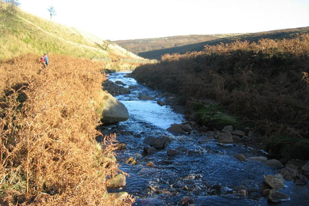
The track drops down below the barn towards a footbridge in the valley below. About 200m before the bridge, a faint path drops away to the left towards the stream to meet a clearer path on the bank where you turn left. This is the valley of the Little Don which to my mind is one of the most beautiful and unspoilt parts of the Dark Peak.
The stream is followed along a clear (but from time to time muddy) path. After 1K, note the solidly built stone sheepfold which served Hordron Farm, visible on the hillside above. The farm is now in ruins, having been evacuated when Langsett Reservoir was constructed in the early 1900s. Interestingly, the names of some of the children who lived there in the late 1800s can still be seen carved into a rock face to the north of Brookhouse Bridge at GR SE198006. Graffiti clearly isn't just a modern phenomenon!
After a further 500m at a path junction, bear left away from the stream and follow the path up the hill. The path continues through a wood and down to a bridge at the foot of Long Moor Clough. Fine views open out over Hingcliff Hill and after 500m, another stream is crossed. Climb up, ignoring a gated path to the left and continue along the edge of the wood, finally climbing away from the stream to a path junction at GR SE198007. Turn left on the track to join the outward route after 250m from where it's a short walk back to the A616 and the start.
For those without their own transport, the start of the walk has good bus links with surrounding towns. Routes 23/4 run to Barnsley at approximately hourly intervals and Holmfirth and Penistone are served by route 20 every two hours. In addition, routes 268/9 link Sheffield and Holmfirth via Langsett on Sundays. All buses stop adjacent to the roundabout at the junction of the A616 and A628 near the Flouch Inn.
Other walks nearby
| Walk 1581 | Langsett Reservoir | easy | 3.0 miles |
| Walk 3401 | From Langsett to Crowden via Woodhead | moderate | 11.0 miles |
| Walk 2826 | Winscar Reservoir circuit from Dunford Bridge | moderate | 8.9 miles |
| Walk 2726 | Penistone Circular from Scout Dike Reservoir | moderate | 8.3 miles |
| Walk 2328 | Penistone to Shepley linear | easy/mod | 8.0 miles |
| Walk 1523 | Broomhead Moor & Ewden Beck | easy/mod | 6.0 miles |
| Walk 2238 | Thurgoland Boundary Walk Oxspring | easy/mod | 8.6 miles |
| Walk 1522 | Back Tor, Bradfield Moors and Reservoirs | moderate | 11.0 miles |
| Walk 1687 | Broomhead & Howden Moors | moderate | 12.4 miles |
| Walk 3049 | Bleaklow Stones from Derwent Valley | mod/hard | 12.0 miles |
Recommended Books & eBooks
Dark Peak Walks
 Guidebook to 40 walks in the Dark Peak area of the Peak District National Park. 35 circular routes for most abilities, from 8km to 19km, around Edale, Marsden, Fairholmes, Baslow and Castleton, including Kinder Scout and Mam Tor, and 5 longer (25km to 45km) routes highlighting the best of the Gritstone Edges, High Moorland and Deep Valleys.
More information
Great Mountain Days in the Pennines
 An inspirational guidebook to 50 classic walks on the rolling Pennine landscape. The graded routes, between 6 and 13 miles in length, cover classic Pennine fells and moorland such as Whernside, Ilkley Moor and Pendle Hill; exploring the North and South Pennines, Yorkshire Dales, Howgills and Dark Peak. Many routes are also suited to fell running.
More information
Messaging & Social Media
Message Walking Britain and follow the latest news.

Mountain Weather
Stay safe on the mountains with detailed weather forecasts - for iOS devices or for Android devices.