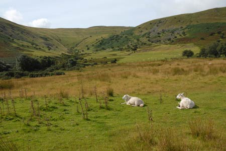
Pen y Fan & Corn Du from Cwmgwdi
Brecon Beacons/Bannau Brycheiniog Walk
Nat Park - Brecon Beacons - Brecon Beacons Central
County/Area - Powys
Author - Lou Johnson
Length - 7.5 miles / 12.2 km Ascent - 2200 feet / 667 metres
Time - 6 hours 0 minutes Grade - moderate
Maps 

| Ordnance Survey Explorer OL12 | Sheet Map | 1:25k | BUY |
| Anquet OS Explorer OL12 | Digital Map | 1:25k | BUY |
| Ordnance Survey Landranger 160 | Sheet Map | 1:50k | BUY |
| Anquet OS Landranger 160 | Digital Map | 1:50k | BUY |
Walk Route Description
Click image to visit gallery of 12 images.
The Brecon Beacons are superb mountains with Pen y Fan, the highest peak in the National Park of the same name, rising to 886 metres. Formed from red sandstone its northern face is dramatic with sheer cliffs dropping into deep cwms divided by ridges. Pen y Fan is often very busy with most walkers approaching the mountain from Storey Arms or other points along the A470. This more challenging route endeavours to avoid the crowds and approaches from the north using one of the pleasant ridges mentioned above.
The start is the car park (grid ref. SO024248), which can be found about half a mile south of Cwmgwdi along a narrow lane. The car park was once the site of an army camp. When parking remember that you will have to walk up the hill into the car park at the end of the day so parking nearer the bottom might be a better option as you can approach the climb fresh. Having parked walk uphill, go through the gate and follow the clear path south. The path climbs easily reaching the ridge linking Allt Ddu with Pen y Fan (grid ref. SO019233). On maps this ridge is named as Cefn Cwm Llwch and offers a superb way onto the Beacons. The path is clear, the views excellent and the grade not too steep apart from the final section up to Pen y Fan’s summit.
Arriving at the summit you are unlikely to enjoy the view by yourself. However it is impossible to deny the spectacular nature of the summit with a 360 degree panorama that covers much of the Brecon Beacons National Park, the hills of mid-Wales, the Usk Valley and South Wales. Continuing, walk west, descending slightly before regaining some of the lost height to reach the summit of Corn Du, which is very similar in character to its higher sister. Far below to the north lies Llyn Cwm Llwch and you should be able to make out the path descending to its north western shore. This path will form the key to our descent.
My preferred route off the summit of Corn Du is to head southwest on the main path leading to the A470. At grid ref SO005209 turn sharp right and head north across the western flank of Corn Du to reach the rim of Cwm Llwch (grid ref. SO002215). You can of course descend from Corn Du around the rim of Cwm Llwch but this always seems to be crowded with people struggling up the path. My route avoids this and is more pleasant under foot.
Continue along the clear path to reach the Obelisk to the lost lad. He was Tommy Jones and went missing on 4th August 1900 - the day the Queen Mother was born. The inscription tells the full story. Continue descending towards Llyn Cwm Llwch. If time and energy permit you can make the short diversion off the main path to the shores of the lake, but most continue ahead descending easily on the clear path. The path has been diverted around the cottage at Cwm-llwch (grid ref SO005237) from where you pick up a track. Follow this to reach a tarmac lane with the stream, on your right.
Follow the lane to reach a junction (grid ref. SO011252). Turn right and continue straight ahead ignoring the lane going off to the left. This lane is generally quiet but do be careful especially on bends where there are potential blind spots for traffic. Reaching a junction (grid ref. SO020252) bear right. This leads you to a further junction (grid ref. SO025251) where you turn right to regain the car park.
Other walks nearby
| Walk 3210 | Pen-y-Crug hill fort from Brecon | easy | 3.0 miles |
| Walk 3564 | Groesfford and M & B Canal from Brecon | easy/mod | 6.2 miles |
| Walk 3236 | Pen-y-crug, Sarnau and Battle from Brecon | moderate | 10.0 miles |
| Walk 2648 | The Black Mountain, Brecon Beacons | moderate | 8.0 miles |
| Walk 2641 | Fan Fawr & Fan Frynych, Fforest Fawr | moderate | 6.5 miles |
| Walk 3209 | Llanfrynach and Pencelli circular | easy/mod | 5.6 miles |
| Walk 2349 | Pen Y Fan & Corn Du from near Storey Arms | moderate | 4.6 miles |
| Walk 3616 | Fan Fawr from Storey Arms | moderate | 6.0 miles |
| Walk 3546 | Pen y Bryn from Pencelli | moderate | 5.0 miles |
| Walk 3536 | Pen y Bryn & Carn Pica from Pencelli | mod/hard | 11.3 miles |
Recommended Books & eBooks
Walking in Carmarthenshire
 Guidebook to 30 walking routes (2 to 10 miles) in Carmarthenshire, south Wales, including sections of Carmarthenshire Coast Path. Walks for all abilities, including coastal, river, forest and hill walks in Cambrian Mountains, Tywi Valley, Y Mynydd Du (Black Mountains) and Brecon Beacons. Easy access from Bristol, Cardiff and Swansea.
More information
Walking on the Brecon Beacons
 45 circular day walks are described in this guidebook to the Brecon Beacons National Park. From west to east, Mynydd Du, Fforest Fawr, the Brecon Beacons and the Black Mountains these mountain and valley routes offer many options, highlighting the natural features. The walks described explore dramatic waterfalls, wooded gorges and upland valleys.
More information
Messaging & Social Media
Message Walking Britain and follow the latest news.

Mountain Weather
Stay safe on the mountains with detailed weather forecasts - for iOS devices or for Android devices.