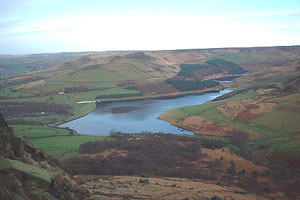
Greenfield Reservoir & Raven Stones from Dovestone
South Pennines Walk
Nat Park - Peak District - Black Hill Dovestone
Region - South Pennines
County/Area - Greater Manchester
Author - Mike Bexley
Length - 8.0 miles / 13 km Ascent - 1800 feet / 545 metres
Time - 5 hours 50 minutes Grade - moderate
Maps 

| Ordnance Survey Explorer OL1 | Sheet Map | 1:25k | BUY |
| Anquet OS Explorer OL1 | Digital Map | 1:25k | BUY |
| Ordnance Survey Landranger 110 | Sheet Map | 1:50k | BUY |
| Anquet OS Landranger 110 | Digital Map | 1:50k | BUY |
Walk Route Description
Click image to see photo description.
A pleasant, not to be hurried Peak District walk following good paths. The rewards are good views across the northern sectors of the Peak District National Park. Note that there is one steep short scramble on grass. For those wanting a longer or more challenging walk than this route can be extended at Fox Stone Cairn and following Walk 2017 in reverse.
The walk starts from the Car Park at Dovestone Reservoir (Grid ref. 013035). Proceed up the lane that exits the car park to the dam wall and take the path alongside the wall with the reservoir on your right. At the end of the dam the path follows the edge of the reservoir to eventually join a lane down to the dam wall of Yeoman Hey Reservoir (Grid ref 020046). This is the second of three reservoirs in this valley.
This reservoir was built in 1880 collecting water from surrounding moors. The mill owners lower down the valley objected to this stating in a high profile Court Case against The Water Board that they were losing their water from their moors. As a result a tunnel was built higher up the valley to by-pass these reservoirs. The tunnel exit can be seen on the other side of the dam. In flood conditions the water thunders through.
Continue along the wide path with Yeoman Hey and later Greenfield Reservoir on your right. The path then follows Greenfield Brook to a weir and the entrance to the tunnel mentioned earlier (Grid ref. 038050). Take the steep path on the right following a brook with numerous waterfalls into Birchen Clough. Choosing an appropriate spot, scramble up the very steep bank on your right.
On reaching the top turn right along a beautiful path that at first follows the edge, passing the Trinnacle and then the Raven Stones. Also look out for Major's Cairn, which was built in memory of a dog and, a little way further on, the large metal cross placed where James Platt MP lost his life in a shooting accident.
The path reaches the high ground overlooking Yeoman Hey Dam (Grid ref 031040). At this point you take the fairly steep winding path down towards the dam wall. You can continue across the dam to retrace your steps to the start but the preferred route is to turn left along a clear path (Grid ref. 022042) keeping Dovestone Reservoir on your right. You pass the Memorial Tree enclosure and the yacht club to reach the start.
Possible extension - If you still have energy and the day is nice, instead of descending from the edge as described above, continue in the same direction stopping for the views across Dovestone Reservoir and the distant villages and towns to reach Fox Stone Cairn (Grid ref 025037), with its plaque telling of the two climbers who lost their lives in the Italian Dolomites. From this point you have two options. (a) Return to the start - The path down from this point is at first very feint. Face the reservoir and drop downhill to the right of Fox Stone to an area of small stones, then turn left with Fox Stone Cairn high on your left, the path contours around the edge to become a clear descending path going through a wide break in the trees. At the stile turn descend left to pick up the path alongside the reservoir. The path passes The Memorial Tree enclosure crosses over a stream then turns right to pass the yacht club back to you start. (b) continue with Walk v017 in reverse to make a total route length of approximately 11 miles.
Other walks nearby
| Walk 2634 | Broadstone Hill & the Cotton Famine Road | moderate | 7.0 miles |
| Walk 2600 | Chew Reservoir & the Pennine Way | mod/hard | 14.0 miles |
| Walk 2914 | The Pots & Pans from Uppermill | easy/mod | 4.5 miles |
| Walk 3607 | Reservoirs Walk from Tintwistle | easy/mod | 5.5 miles |
| Walk 2521 | Hollingworthall Moor & Walkerwood Reservoirs | moderate | 7.0 miles |
| Walk 1179 | Lad's Leap & Laddow Rocks from Crowden | moderate | 6.5 miles |
| Walk 2621 | Black Hill & Laddow Rocks | moderate | 9.0 miles |
| Walk 3022 | Black Hill | moderate | 9.0 miles |
| Walk 2375 | The Longendale Edges | mod/hard | 11.8 miles |
| Walk 2518 | Black Hill & Four Reservoirs from near Wessenden Head | moderate | 10.0 miles |
Recommended Books & eBooks
Walking in the Peak District - White Peak East
 Guidebook describing 42 half-day and day walks in the limestone landscapes of Derbyshire's White Peak, part of the Peak District National Park. One of two volumes, this book covers the east of the region, with potential bases including Bakewell, Eyam, Castleton, Birchover, Matlock and Wirksworth.
More information
Dark Peak Walks
 Guidebook to 40 walks in the Dark Peak area of the Peak District National Park. 35 circular routes for most abilities, from 8km to 19km, around Edale, Marsden, Fairholmes, Baslow and Castleton, including Kinder Scout and Mam Tor, and 5 longer (25km to 45km) routes highlighting the best of the Gritstone Edges, High Moorland and Deep Valleys.
More information
Messaging & Social Media
Message Walking Britain and follow the latest news.

Mountain Weather
Stay safe on the mountains with detailed weather forecasts - for iOS devices or for Android devices.