Fan Gyhirych, Fan Nedd & Fan Bwlch Chwyth
Brecon Beacons/Bannau Brycheiniog Walk
Nat Park - Brecon Beacons - Brecon Beacons West
County/Area - Powys
Author - Hugh Maguire
Length - 10.0 miles / 16.3 km Ascent - 2200 feet / 667 metres
Time - 7 hours 10 minutes Grade - moderate
Maps 

| Ordnance Survey Explorer OL12 | Sheet Map | 1:25k | BUY |
| Anquet OS Explorer OL12 | Digital Map | 1:25k | BUY |
| Ordnance Survey Landranger 160 | Sheet Map | 1:50k | BUY |
| Anquet OS Landranger 160 | Digital Map | 1:50k | BUY |
Walk Route Description
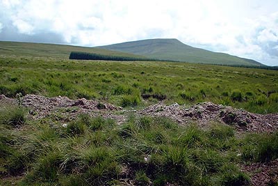
Click image to visit gallery of 3 images.
The area immediately west of A4067 near Cray Reservoir offers some excellent hill walking. This walk, walk 2645 and walk 2646 are based on the same starting point are variations on a theme.
Take the road leading north east from the A4067 opposite the Cray Resevoir. The walks) starts on a track on the right just over half a mile along this road (Grid ref. SN 896222). There is quite a bit of parking space at the start of the track but keep away from the gate as this is sometimes used by lorries visiting the quarry further up the track.
This walk offers no navigational problems and involves following the track (don't take the LH fork) for several miles until it starts to descend at which point you walk north west for a short distance to the trig point on Fan Gyhirych (Grid ref. SN 880190). This a good place for a break with spectacular views. Although the track climbs all the way it is actually quite easy walking.
Descend the track used on the ascent and at about grid ref. SN 900196 branch right onto another track. Follow it and head south east. You can see Fan Nedd in front of you as you drop downhill into a bit of boggy area. You then follow the track up Fan Nedd to the top (Grid ref. SN 913183). Once again a good place to stop with excellent views.
Return to the main track and then bear north and then east along the ridge to the trig point on Fan Bwlch Chwyth (Grid ref. SN 912216). From here walk just north of west back to the start. This last bit can be a bit harder, crossing the stream's deep valley, but is still ok.
Other walks nearby
| Walk 3563 | Fan Brycheiniog and Picws Du | moderate | 7.1 miles |
| Walk 2643 | Fan Frynych & Fan Llia, Fforest Fawr | moderate | 8.0 miles |
| Walk 2641 | Fan Fawr & Fan Frynych, Fforest Fawr | moderate | 6.5 miles |
| Walk 2648 | The Black Mountain, Brecon Beacons | moderate | 8.0 miles |
| Walk 3616 | Fan Fawr from Storey Arms | moderate | 6.0 miles |
| Walk 2194 | Mynydd y Llan & source of the Usk | easy/mod | 6.7 miles |
| Walk 2349 | Pen Y Fan & Corn Du from near Storey Arms | moderate | 4.6 miles |
| Walk 3559 | Picws Du & Llyn y Fan Fach from near Llanddeusant | moderate | 5.3 miles |
| Walk 3205 | Carnau Gwynion from Ystradfellte | easy | 4.0 miles |
| Walk 3206 | Ystradfellte Waterfalls Walk | moderate | 9.2 miles |
Recommended Books & eBooks
Walking on the Brecon Beacons
 45 circular day walks are described in this guidebook to the Brecon Beacons National Park. From west to east, Mynydd Du, Fforest Fawr, the Brecon Beacons and the Black Mountains these mountain and valley routes offer many options, highlighting the natural features. The walks described explore dramatic waterfalls, wooded gorges and upland valleys.
More information
The Cambrian Way
 Guidebook to the Cambrian Way, a challenging three-week mountain trek through Wales from Cardiff to Conwy. The 470km un-waymarked route is presented from south to north. Often sticking to long, beautiful ridgelines, it crosses wild and rugged terrain and visits many of Wales's highest mountains, including Snowdon.
More information
Messaging & Social Media
Message Walking Britain and follow the latest news.

Mountain Weather
Stay safe on the mountains with detailed weather forecasts - for iOS devices or for Android devices.